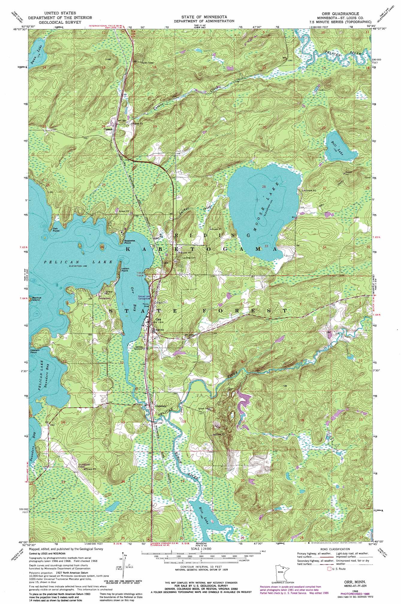
Orr Topo Map Minnesota
To zoom in, hover over the map of Orr
USGS Topo Quad 48092a7 - 1:24,000 scale
| Topo Map Name: | Orr |
| USGS Topo Quad ID: | 48092a7 |
| Print Size: | ca. 21 1/4" wide x 27" high |
| Southeast Coordinates: | 48° N latitude / 92.75° W longitude |
| Map Center Coordinates: | 48.0625° N latitude / 92.8125° W longitude |
| U.S. State: | MN |
| Filename: | o48092a7.jpg |
| Download Map JPG Image: | Orr topo map 1:24,000 scale |
| Map Type: | Topographic |
| Topo Series: | 7.5´ |
| Map Scale: | 1:24,000 |
| Source of Map Images: | United States Geological Survey (USGS) |
| Alternate Map Versions: |
Orr MN 1968, updated 1987 Download PDF Buy paper map Orr MN 1969, updated 1971 Download PDF Buy paper map Orr MN 2011 Download PDF Buy paper map Orr MN 2013 Download PDF Buy paper map Orr MN 2016 Download PDF Buy paper map |
| FStopo: | US Forest Service topo Orr is available: Download FStopo PDF Download FStopo TIF |
1:24,000 Topo Quads surrounding Orr
Ray Se |
Ash River Sw |
Ash River Se |
Marion Lake |
Johnson Lake |
Nett Lake Ne |
Ash Lake |
Orr Ne |
Elephant Lake |
Kabustasa Lake |
Nett Lake |
Orr Sw |
Orr |
Myrtle Lake |
Buyck |
Silverdale |
Gheen Nw |
Gheen |
Haley |
Norwegian Bay |
Bear River |
Meadow Brook |
Linden Grove |
Cook |
Sassas Creek |
> Back to 48092a1 at 1:100,000 scale
> Back to 48092a1 at 1:250,000 scale
> Back to U.S. Topo Maps home
Orr topo map: Gazetteer
Orr: Airports
Orr Regional Airport elevation 401m 1315′Pelican Lake Seaplane Base elevation 400m 1312′
Orr: Bays
Orr Bay elevation 393m 1289′Orr: Capes
Bessette Point elevation 403m 1322′Haslam Point elevation 399m 1309′
Indian Point elevation 393m 1289′
Oak Point elevation 397m 1302′
Orr: Dams
Pelican Lake Dam elevation 396m 1299′Wilbur Luoma Pond Dam elevation 406m 1332′
Orr: Lakes
Bell Lake elevation 408m 1338′Moose Lake elevation 404m 1325′
Rice Lake elevation 392m 1286′
Swan Lake elevation 401m 1315′
Orr: Parks
Orr Roadside Parking Area elevation 395m 1295′Orr: Populated Places
Cusson elevation 406m 1332′Glendale elevation 396m 1299′
Orr elevation 398m 1305′
Orr: Post Offices
Cusson Post Office (historical) elevation 406m 1332′Orr Post Office elevation 399m 1309′
Orr: Reservoirs
Pelican Lake elevation 396m 1299′Wilbur Luoma Pond elevation 406m 1332′
Orr: Streams
Cusson Creek elevation 387m 1269′Elbow River elevation 393m 1289′
Sucker Creek elevation 393m 1289′
Orr digital topo map on disk
Buy this Orr topo map showing relief, roads, GPS coordinates and other geographical features, as a high-resolution digital map file on DVD: