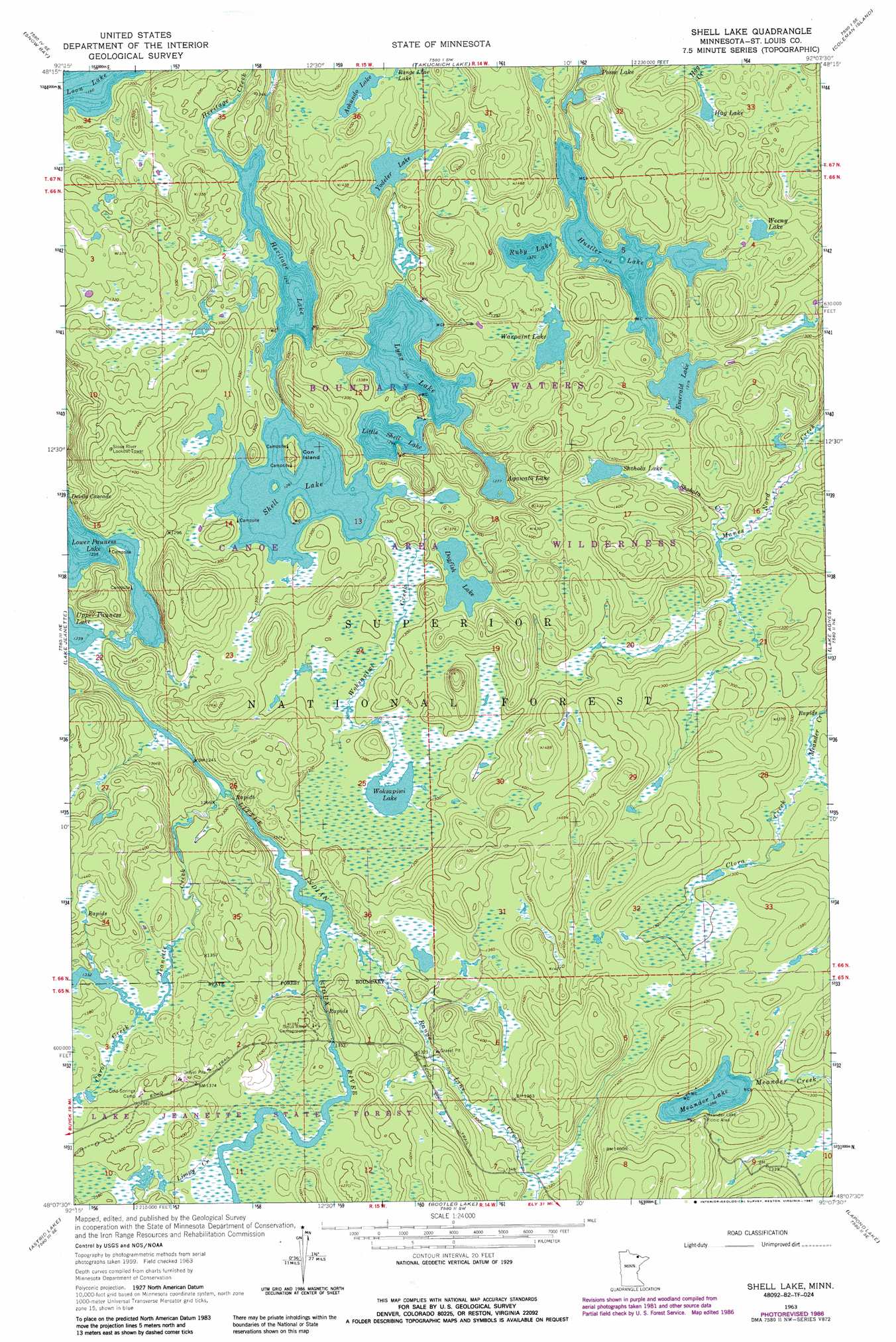
Shell Lake Topo Map Minnesota
To zoom in, hover over the map of Shell Lake
USGS Topo Quad 48092b2 - 1:24,000 scale
| Topo Map Name: | Shell Lake |
| USGS Topo Quad ID: | 48092b2 |
| Print Size: | ca. 21 1/4" wide x 27" high |
| Southeast Coordinates: | 48.125° N latitude / 92.125° W longitude |
| Map Center Coordinates: | 48.1875° N latitude / 92.1875° W longitude |
| U.S. State: | MN |
| Filename: | o48092b2.jpg |
| Download Map JPG Image: | Shell Lake topo map 1:24,000 scale |
| Map Type: | Topographic |
| Topo Series: | 7.5´ |
| Map Scale: | 1:24,000 |
| Source of Map Images: | United States Geological Survey (USGS) |
| Alternate Map Versions: |
Shell Lake MN 1963, updated 1965 Download PDF Buy paper map Shell Lake MN 1963, updated 1987 Download PDF Buy paper map Shell Lake MN 2011 Download PDF Buy paper map Shell Lake MN 2013 Download PDF Buy paper map Shell Lake MN 2016 Download PDF Buy paper map |
| FStopo: | US Forest Service topo Shell Lake is available: Download FStopo PDF Download FStopo TIF |
1:24,000 Topo Quads surrounding Shell Lake
Redhorse Bay |
||||
Crane Lake |
Snow Bay |
Takucmich Lake |
Coleman Island |
|
Echo Lake |
Lake Jeanette |
Shell Lake |
Lake Agnes |
Iron Lake |
Picket Lake |
Astrid Lake |
Bootleg Lake |
Lapond Lake |
Angleworm Lake |
Vermilion Dam |
Sioux Pine Island |
Chad Lake |
Crab Lake |
Shagawa Lake |
> Back to 48092a1 at 1:100,000 scale
> Back to 48092a1 at 1:250,000 scale
> Back to U.S. Topo Maps home
Shell Lake topo map: Gazetteer
Shell Lake: Islands
Con Island elevation 400m 1312′Shell Lake: Lakes
Achundo Lake elevation 403m 1322′Agawato Lake elevation 386m 1266′
Dogfish Lake elevation 397m 1302′
Emerald Lake elevation 398m 1305′
Hag Lake elevation 411m 1348′
Heritage Lake elevation 379m 1243′
Hustler Lake elevation 397m 1302′
Little Shell Lake elevation 385m 1263′
Lower Pauness Lake elevation 377m 1236′
Lynx Lake elevation 385m 1263′
Meander Lake elevation 421m 1381′
Ruby Lake elevation 403m 1322′
Shell Lake elevation 385m 1263′
Shohola Lake elevation 403m 1322′
Warpaint Lake elevation 404m 1325′
Weeny Lake elevation 403m 1322′
Woksapiwi Lake elevation 391m 1282′
Yodeler Lake elevation 397m 1302′
Shell Lake: Streams
Carol Creek elevation 406m 1332′Clora Creek elevation 382m 1253′
Jeanette Creek elevation 382m 1253′
Limpy Creek elevation 412m 1351′
Meander Creek elevation 377m 1236′
Range Line Creek elevation 389m 1276′
Shohola Creek elevation 388m 1272′
Woksapiwi Creek elevation 385m 1263′
Shell Lake digital topo map on disk
Buy this Shell Lake topo map showing relief, roads, GPS coordinates and other geographical features, as a high-resolution digital map file on DVD: