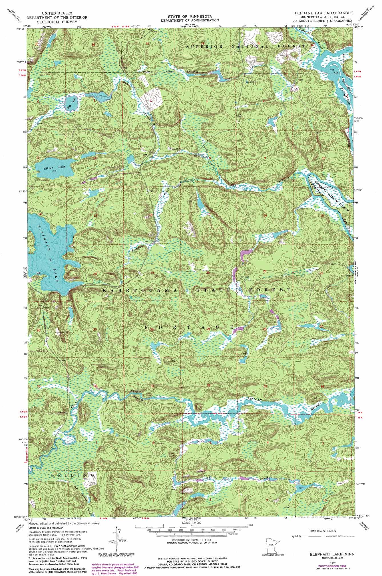
Elephant Lake Topo Map Minnesota
To zoom in, hover over the map of Elephant Lake
USGS Topo Quad 48092b6 - 1:24,000 scale
| Topo Map Name: | Elephant Lake |
| USGS Topo Quad ID: | 48092b6 |
| Print Size: | ca. 21 1/4" wide x 27" high |
| Southeast Coordinates: | 48.125° N latitude / 92.625° W longitude |
| Map Center Coordinates: | 48.1875° N latitude / 92.6875° W longitude |
| U.S. State: | MN |
| Filename: | o48092b6.jpg |
| Download Map JPG Image: | Elephant Lake topo map 1:24,000 scale |
| Map Type: | Topographic |
| Topo Series: | 7.5´ |
| Map Scale: | 1:24,000 |
| Source of Map Images: | United States Geological Survey (USGS) |
| Alternate Map Versions: |
Elephant Lake MN 1967, updated 1970 Download PDF Buy paper map Elephant Lake MN 1967, updated 1987 Download PDF Buy paper map Elephant Lake MN 2011 Download PDF Buy paper map Elephant Lake MN 2013 Download PDF Buy paper map Elephant Lake MN 2016 Download PDF Buy paper map |
| FStopo: | US Forest Service topo Elephant Lake is available: Download FStopo PDF Download FStopo TIF |
1:24,000 Topo Quads surrounding Elephant Lake
Daley Bay |
Ash River Ne |
Namakan Island |
Hale Bay |
Redhorse Bay |
Ash River Sw |
Ash River Se |
Marion Lake |
Johnson Lake |
Crane Lake |
Ash Lake |
Orr Ne |
Elephant Lake |
Kabustasa Lake |
Echo Lake |
Orr Sw |
Orr |
Myrtle Lake |
Buyck |
Picket Lake |
Gheen Nw |
Gheen |
Haley |
Norwegian Bay |
Vermilion Dam |
> Back to 48092a1 at 1:100,000 scale
> Back to 48092a1 at 1:250,000 scale
> Back to U.S. Topo Maps home
Elephant Lake topo map: Gazetteer
Elephant Lake: Forests
Kabetogama State Forest elevation 400m 1312′Elephant Lake: Lakes
Bug Lake elevation 395m 1295′Elephant Lake elevation 398m 1305′
Silver Lake elevation 401m 1315′
Elephant Lake: Streams
Bug Creek elevation 365m 1197′Clear Creek elevation 384m 1259′
Elephant Creek elevation 379m 1243′
Flap Creek elevation 364m 1194′
Marion Creek elevation 365m 1197′
Elephant Lake digital topo map on disk
Buy this Elephant Lake topo map showing relief, roads, GPS coordinates and other geographical features, as a high-resolution digital map file on DVD: