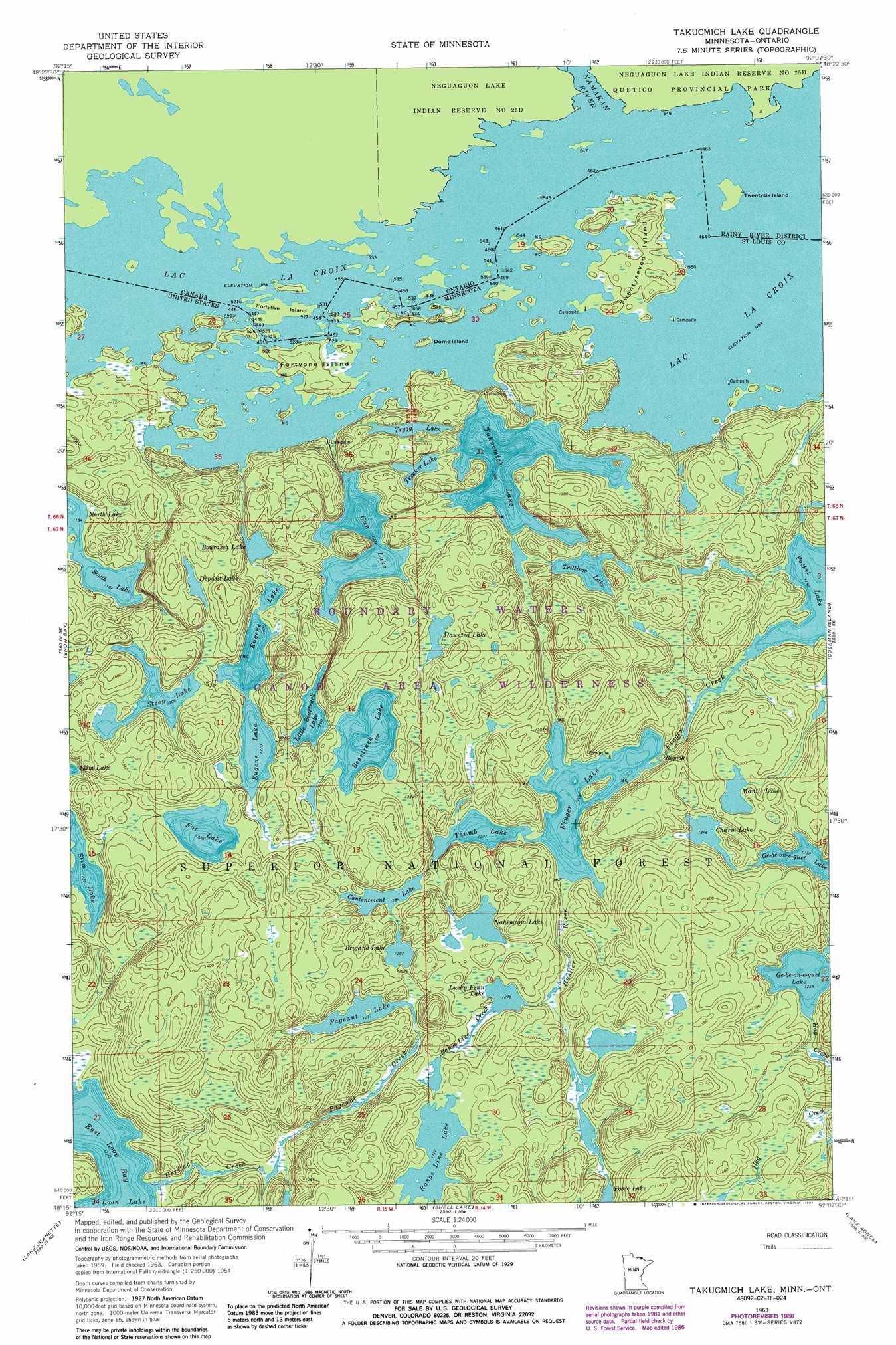
Takucmich Lake Topo Map Minnesota
To zoom in, hover over the map of Takucmich Lake
USGS Topo Quad 48092c2 - 1:24,000 scale
| Topo Map Name: | Takucmich Lake |
| USGS Topo Quad ID: | 48092c2 |
| Print Size: | ca. 21 1/4" wide x 27" high |
| Southeast Coordinates: | 48.25° N latitude / 92.125° W longitude |
| Map Center Coordinates: | 48.3125° N latitude / 92.1875° W longitude |
| U.S. State: | MN |
| Filename: | o48092c2.jpg |
| Download Map JPG Image: | Takucmich Lake topo map 1:24,000 scale |
| Map Type: | Topographic |
| Topo Series: | 7.5´ |
| Map Scale: | 1:24,000 |
| Source of Map Images: | United States Geological Survey (USGS) |
| Alternate Map Versions: |
Takucmich Lake MN 1963, updated 1964 Download PDF Buy paper map Takucmich Lake MN 1963, updated 1987 Download PDF Buy paper map Takucmich Lake MN 2011 Download PDF Buy paper map Takucmich Lake MN 2013 Download PDF Buy paper map Takucmich Lake MN 2016 Download PDF Buy paper map |
| FStopo: | US Forest Service topo Takucmich Lake is available: Download FStopo PDF Download FStopo TIF |
1:24,000 Topo Quads surrounding Takucmich Lake
Redhorse Bay |
||||
Crane Lake |
Snow Bay |
Takucmich Lake |
Coleman Island |
|
Echo Lake |
Lake Jeanette |
Shell Lake |
Lake Agnes |
Iron Lake |
Picket Lake |
Astrid Lake |
Bootleg Lake |
Lapond Lake |
Angleworm Lake |
> Back to 48092a1 at 1:100,000 scale
> Back to 48092a1 at 1:250,000 scale
> Back to U.S. Topo Maps home
Takucmich Lake topo map: Gazetteer
Takucmich Lake: Bays
East Loon Bay elevation 354m 1161′Takucmich Lake: Islands
Dome Island elevation 370m 1213′Fortyone Island elevation 374m 1227′
Twentyseven Island elevation 370m 1213′
Takucmich Lake: Lakes
Beartrack Lake elevation 397m 1302′Bourassa Lake elevation 373m 1223′
Brigand Lake elevation 391m 1282′
Charm Lake elevation 379m 1243′
Contentment Lake elevation 391m 1282′
Deposit Lake elevation 403m 1322′
Eugene Lake elevation 385m 1263′
Fat Lake elevation 397m 1302′
Finger Lake elevation 373m 1223′
Gun Lake elevation 373m 1223′
Haunted Lake elevation 409m 1341′
Little Beartrack Lake elevation 391m 1282′
Lucky Finn Lake elevation 388m 1272′
Mantle Lake elevation 391m 1282′
Nahimana Lake elevation 391m 1282′
Pageant Lake elevation 385m 1263′
Posse Lake elevation 385m 1263′
Range Line Lake elevation 403m 1322′
South Lake elevation 361m 1184′
Steep Lake elevation 397m 1302′
Takucmich Lake elevation 367m 1204′
Tesaker Lake elevation 373m 1223′
Thumb Lake elevation 373m 1223′
Trillium Lake elevation 373m 1223′
Trygg Lake elevation 379m 1243′
Takucmich Lake: Streams
Finger Creek elevation 364m 1194′Hag Creek elevation 375m 1230′
Heritage Creek elevation 354m 1161′
Hustler River elevation 375m 1230′
Pageant Creek elevation 367m 1204′
Range Line Creek elevation 388m 1272′
Takucmich Lake digital topo map on disk
Buy this Takucmich Lake topo map showing relief, roads, GPS coordinates and other geographical features, as a high-resolution digital map file on DVD: