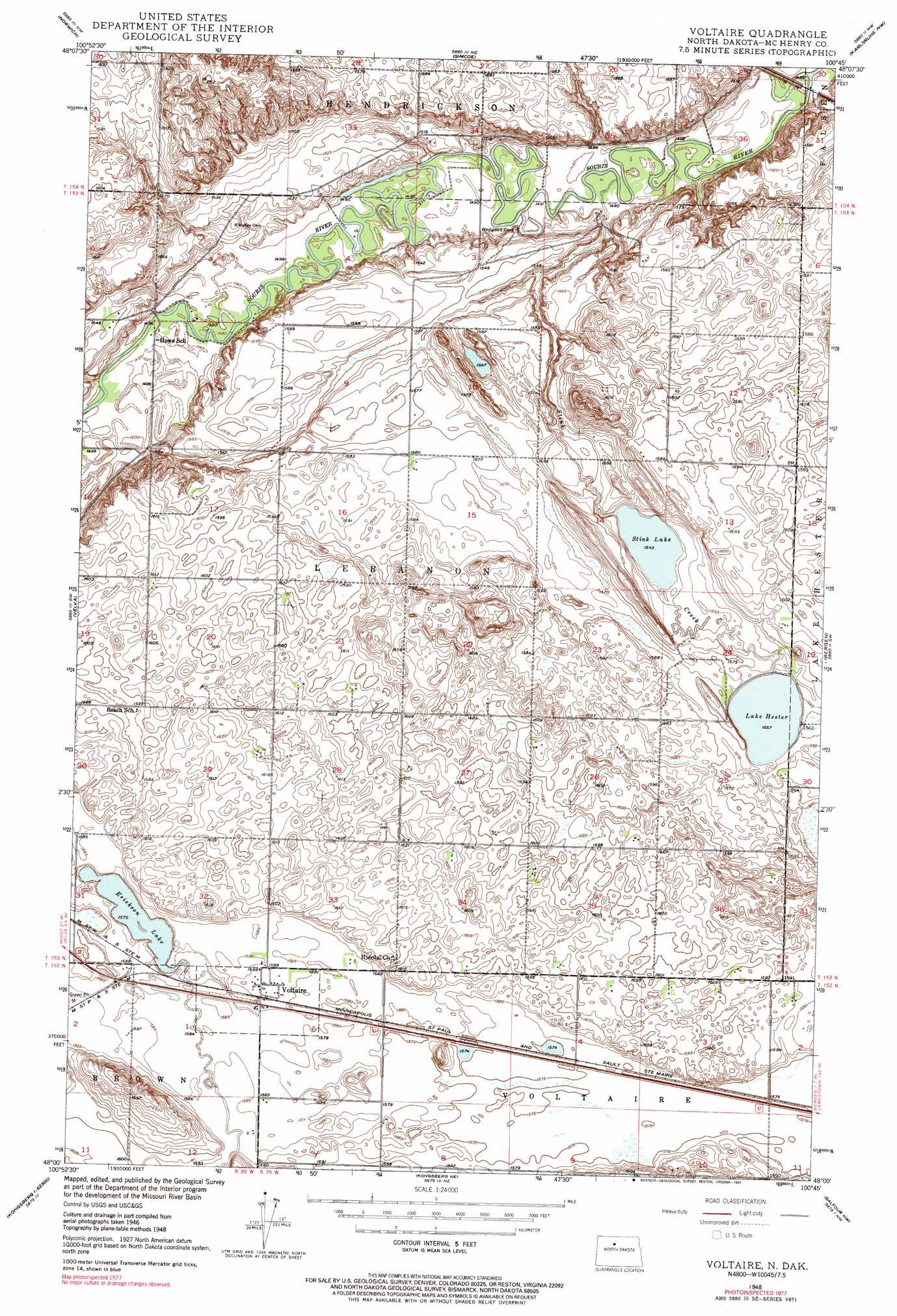
Voltaire Topo Map North Dakota
To zoom in, hover over the map of Voltaire
USGS Topo Quad 48100a7 - 1:24,000 scale
| Topo Map Name: | Voltaire |
| USGS Topo Quad ID: | 48100a7 |
| Print Size: | ca. 21 1/4" wide x 27" high |
| Southeast Coordinates: | 48° N latitude / 100.75° W longitude |
| Map Center Coordinates: | 48.0625° N latitude / 100.8125° W longitude |
| U.S. State: | ND |
| Filename: | O48100A7.jpg |
| Download Map JPG Image: | Voltaire topo map 1:24,000 scale |
| Map Type: | Topographic |
| Topo Series: | 7.5´ |
| Map Scale: | 1:24,000 |
| Source of Map Images: | United States Geological Survey (USGS) |
| Alternate Map Versions: |
Voltaire ND 1948, updated 1955 Download PDF Buy paper map Voltaire ND 1948, updated 1955 Download PDF Buy paper map Voltaire ND 1948, updated 1956 Download PDF Buy paper map Voltaire ND 1948, updated 1965 Download PDF Buy paper map Voltaire ND 1948, updated 1969 Download PDF Buy paper map Voltaire ND 1948, updated 1991 Download PDF Buy paper map Voltaire ND 1948, updated 1991 Download PDF Buy paper map Voltaire ND 1949, updated 1949 Download PDF Buy paper map Voltaire ND 1949, updated 1954 Download PDF Buy paper map Voltaire ND 2011 Download PDF Buy paper map Voltaire ND 2014 Download PDF Buy paper map |
1:24,000 Topo Quads surrounding Voltaire
Deering Se |
Granville Sw |
Granville |
Riga |
Denbigh |
Sawyer Ne |
Norwich |
Simcoe |
Karlsruhe Nw |
Karlsruhe Ne |
Sawyer |
Velva |
Voltaire |
Bergen |
Karlsruhe |
Robinson Coulee |
Blacktail Coulee |
Kongsberg Ne |
Balfour Nw |
Balfour |
Benedict |
Ruso |
Kongsberg |
Butte |
Kief |
> Back to 48100a1 at 1:100,000 scale
> Back to 48100a1 at 1:250,000 scale
> Back to U.S. Topo Maps home
Voltaire topo map: Gazetteer
Voltaire: Airports
Doyle Landing Strip elevation 491m 1610′Voltaire: Lakes
Erickson Lake elevation 480m 1574′Lake Hester elevation 475m 1558′
Stink Lake elevation 471m 1545′
Voltaire: Populated Places
Voltaire elevation 484m 1587′Voltaire: Streams
Stink Creek elevation 449m 1473′Voltaire: Valleys
Blacktail Coulee elevation 480m 1574′Voltaire digital topo map on disk
Buy this Voltaire topo map showing relief, roads, GPS coordinates and other geographical features, as a high-resolution digital map file on DVD:
Eastern North Dakota & Eastern South Dakota
Buy digital topo maps: Eastern North Dakota & Eastern South Dakota