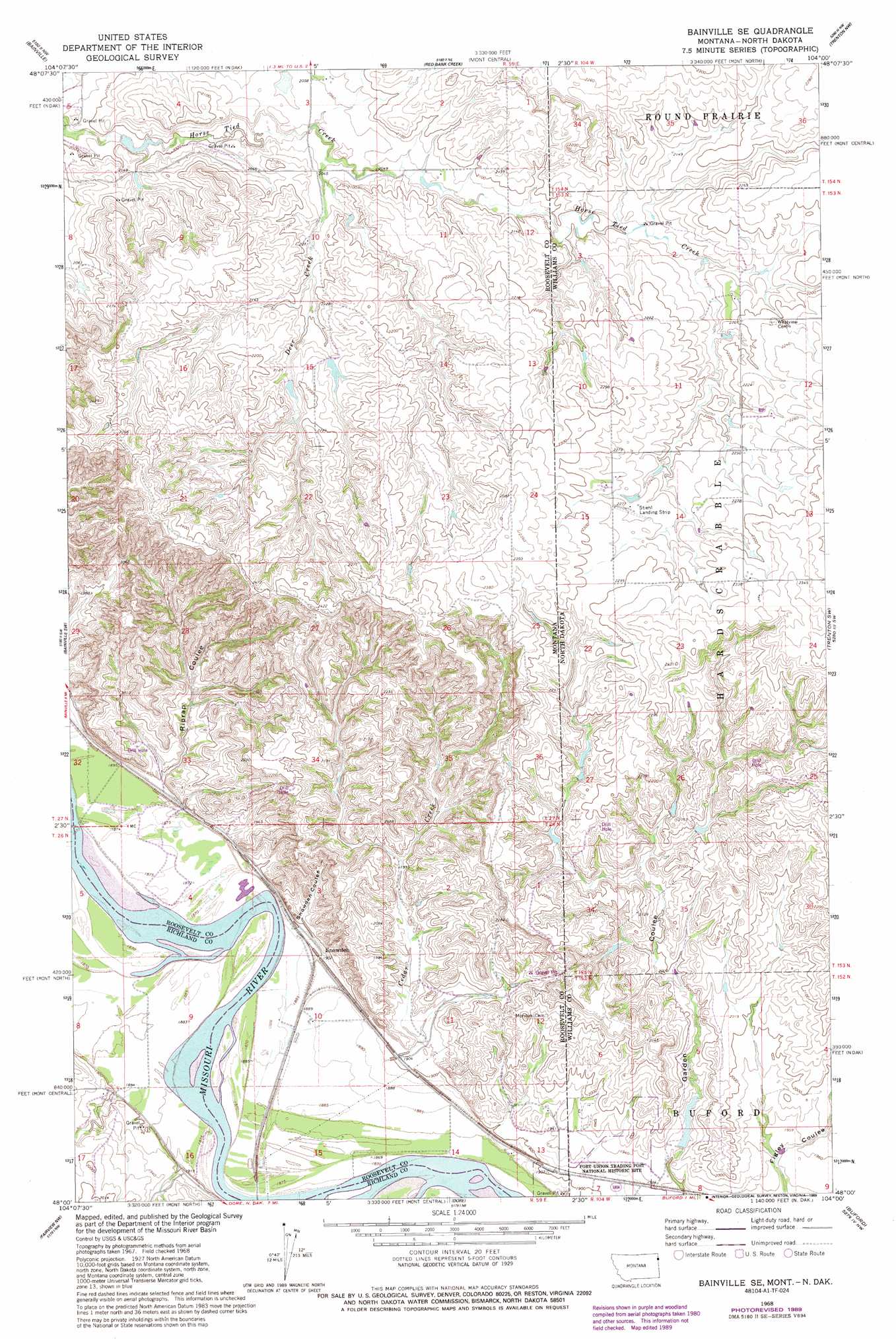
Bainville Se Topo Map Montana
To zoom in, hover over the map of Bainville Se
USGS Topo Quad 48104a1 - 1:24,000 scale
| Topo Map Name: | Bainville Se |
| USGS Topo Quad ID: | 48104a1 |
| Print Size: | ca. 21 1/4" wide x 27" high |
| Southeast Coordinates: | 48° N latitude / 104° W longitude |
| Map Center Coordinates: | 48.0625° N latitude / 104.0625° W longitude |
| U.S. States: | MT, ND |
| Filename: | o48104a1.jpg |
| Download Map JPG Image: | Bainville Se topo map 1:24,000 scale |
| Map Type: | Topographic |
| Topo Series: | 7.5´ |
| Map Scale: | 1:24,000 |
| Source of Map Images: | United States Geological Survey (USGS) |
| Alternate Map Versions: |
Bainville SE MT 1968, updated 1971 Download PDF Buy paper map Bainville SE MT 1968, updated 1989 Download PDF Buy paper map Bainville SE MT 2011 Download PDF Buy paper map Bainville SE MT 2014 Download PDF Buy paper map |
1:24,000 Topo Quads surrounding Bainville Se
Froid Se |
Brush Mountain Sw |
Bull Butte |
Bonetraill Sw |
Bonetraill Se |
Mccabe East |
Bainville |
Red Bank Creek |
Trenton Nw |
Trenton Ne |
Cedar Coulee |
Bainville Sw |
Bainville Se |
Trenton Sw |
Trenton |
Sioux Pass |
Fairview Nw |
Dore |
Buford |
Cartwright Ne |
Brorson |
Fairview Sw |
Fairview |
Cartwright |
Charbonneau |
> Back to 48104a1 at 1:100,000 scale
> Back to 48104a1 at 1:250,000 scale
> Back to U.S. Topo Maps home
Bainville Se topo map: Gazetteer
Bainville Se: Airports
Stiehl Field elevation 685m 2247′Bainville Se: Bridges
Snowden Bridge elevation 569m 1866′Bainville Se: Dams
Iranian Dam elevation 622m 2040′Nordell Dam elevation 595m 1952′
Bainville Se: Parks
Fort Union Trading Post National Historic Site elevation 575m 1886′Fort Union Trading Post National Historic Site elevation 578m 1896′
Bainville Se: Populated Places
Fort Union (historical) elevation 596m 1955′Snowden elevation 578m 1896′
Bainville Se: Post Offices
Fort Union Post Office (historical) elevation 596m 1955′Bainville Se: Streams
Berry Creek elevation 576m 1889′Cedar Creek elevation 578m 1896′
Deer Creek elevation 618m 2027′
Bainville Se: Valleys
Riprap Coulee elevation 580m 1902′Snowden Coulee elevation 580m 1902′
Bainville Se: Wells
26N59E02CCAD01 Well elevation 593m 1945′26N59E03AC__01 Well elevation 663m 2175′
26N59E08AC__01 Well elevation 573m 1879′
26N59E08DDCA01 Well elevation 579m 1899′
26N59E09CA__01 Well elevation 570m 1870′
26N59E10BD__01 Well elevation 578m 1896′
26N59E10CA__01 Well elevation 576m 1889′
26N59E10DD__01 Well elevation 577m 1893′
26N59E11BC__01 Well elevation 588m 1929′
26N59E11DB__01 Well elevation 623m 2043′
26N59E15AD__01 Well elevation 574m 1883′
26N59E15BD__01 Well elevation 574m 1883′
26N59E17AA__01 Well elevation 586m 1922′
27N59E03AC__01 Well elevation 630m 2066′
27N59E05AC__01 Well elevation 600m 1968′
27N59E35BA__01 Well elevation 660m 2165′
Bainville Se digital topo map on disk
Buy this Bainville Se topo map showing relief, roads, GPS coordinates and other geographical features, as a high-resolution digital map file on DVD:
Eastern Montana & Western North Dakota
Buy digital topo maps: Eastern Montana & Western North Dakota