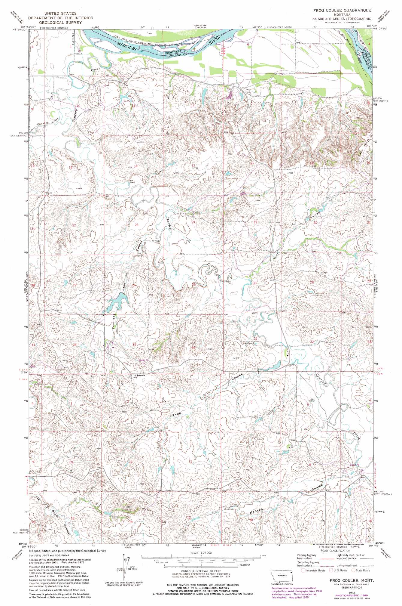
Frog Coulee Topo Map Montana
To zoom in, hover over the map of Frog Coulee
USGS Topo Quad 48104a7 - 1:24,000 scale
| Topo Map Name: | Frog Coulee |
| USGS Topo Quad ID: | 48104a7 |
| Print Size: | ca. 21 1/4" wide x 27" high |
| Southeast Coordinates: | 48° N latitude / 104.75° W longitude |
| Map Center Coordinates: | 48.0625° N latitude / 104.8125° W longitude |
| U.S. State: | MT |
| Filename: | o48104a7.jpg |
| Download Map JPG Image: | Frog Coulee topo map 1:24,000 scale |
| Map Type: | Topographic |
| Topo Series: | 7.5´ |
| Map Scale: | 1:24,000 |
| Source of Map Images: | United States Geological Survey (USGS) |
| Alternate Map Versions: |
Frog Coulee MT 1972, updated 1975 Download PDF Buy paper map Frog Coulee MT 1972, updated 1989 Download PDF Buy paper map Frog Coulee MT 2011 Download PDF Buy paper map Frog Coulee MT 2014 Download PDF Buy paper map |
1:24,000 Topo Quads surrounding Frog Coulee
Geddart Lake |
Smoke Creek Sw |
Coyote Coulee |
Rocky Point |
Johnson Lake |
Poplar Ne |
Brockton |
Calais |
Fort Kipp |
Culbertson |
Sprole |
Mortarstone Bluff |
Frog Coulee |
Twomile Creek |
Dugout Creek |
Duplisse Creek North |
Elmdale Nw |
Elmdale |
Elm Coulee |
Andes |
Duplisse Creek South |
Elmdale Sw |
Carda Coulee |
Three Buttes Creek West |
Three Buttes Creek East |
> Back to 48104a1 at 1:100,000 scale
> Back to 48104a1 at 1:250,000 scale
> Back to U.S. Topo Maps home
Frog Coulee topo map: Gazetteer
Frog Coulee: Cliffs
Balls Bluff elevation 674m 2211′Frog Coulee: Dams
Foss Dam elevation 665m 2181′Foss Farms Number 3 Dam elevation 660m 2165′
Harfo Dam elevation 598m 1961′
R Schmitz Number 1 Dam elevation 624m 2047′
Frog Coulee: Streams
Charlie Creek elevation 584m 1916′East Charlie Creek elevation 592m 1942′
West Charlie Creek elevation 592m 1942′
Frog Coulee: Valleys
Frog Coulee elevation 622m 2040′Hanson Coulee elevation 628m 2060′
Promised Land Coulee elevation 603m 1978′
Wolf Coulee elevation 617m 2024′
Frog Coulee: Wells
26N54E09CACA01 Well elevation 633m 2076′26N54E17DCAA01 Well elevation 671m 2201′
27N53E01CC__01 Well elevation 585m 1919′
27N53E01CD__01 Well elevation 585m 1919′
27N53E03DBAA01 Well elevation 592m 1942′
27N53E09DD__01 Well elevation 593m 1945′
27N53E09DD__02 Well elevation 593m 1945′
27N53E10BC__01 Well elevation 599m 1965′
27N53E10BC__02 Well elevation 599m 1965′
27N53E10CC__01 Well elevation 592m 1942′
27N53E12AB__01 Well elevation 586m 1922′
27N53E34AAAA01 Well elevation 631m 2070′
27N54E07BA__01 Well elevation 586m 1922′
27N54E07BA__02 Well elevation 586m 1922′
27N54E07BB__01 Well elevation 586m 1922′
27N54E07BD__01 Well elevation 598m 1961′
27N54E08BD__01 Well elevation 592m 1942′
27N54E08CC__01 Well elevation 639m 2096′
27N54E08CC__02 Well elevation 639m 2096′
27N54E09BB__01 Well elevation 585m 1919′
27N54E09BC__01 Well elevation 594m 1948′
Frog Coulee digital topo map on disk
Buy this Frog Coulee topo map showing relief, roads, GPS coordinates and other geographical features, as a high-resolution digital map file on DVD:
Eastern Montana & Western North Dakota
Buy digital topo maps: Eastern Montana & Western North Dakota