Bainville Topo Map Montana
To zoom in, hover over the map of Bainville
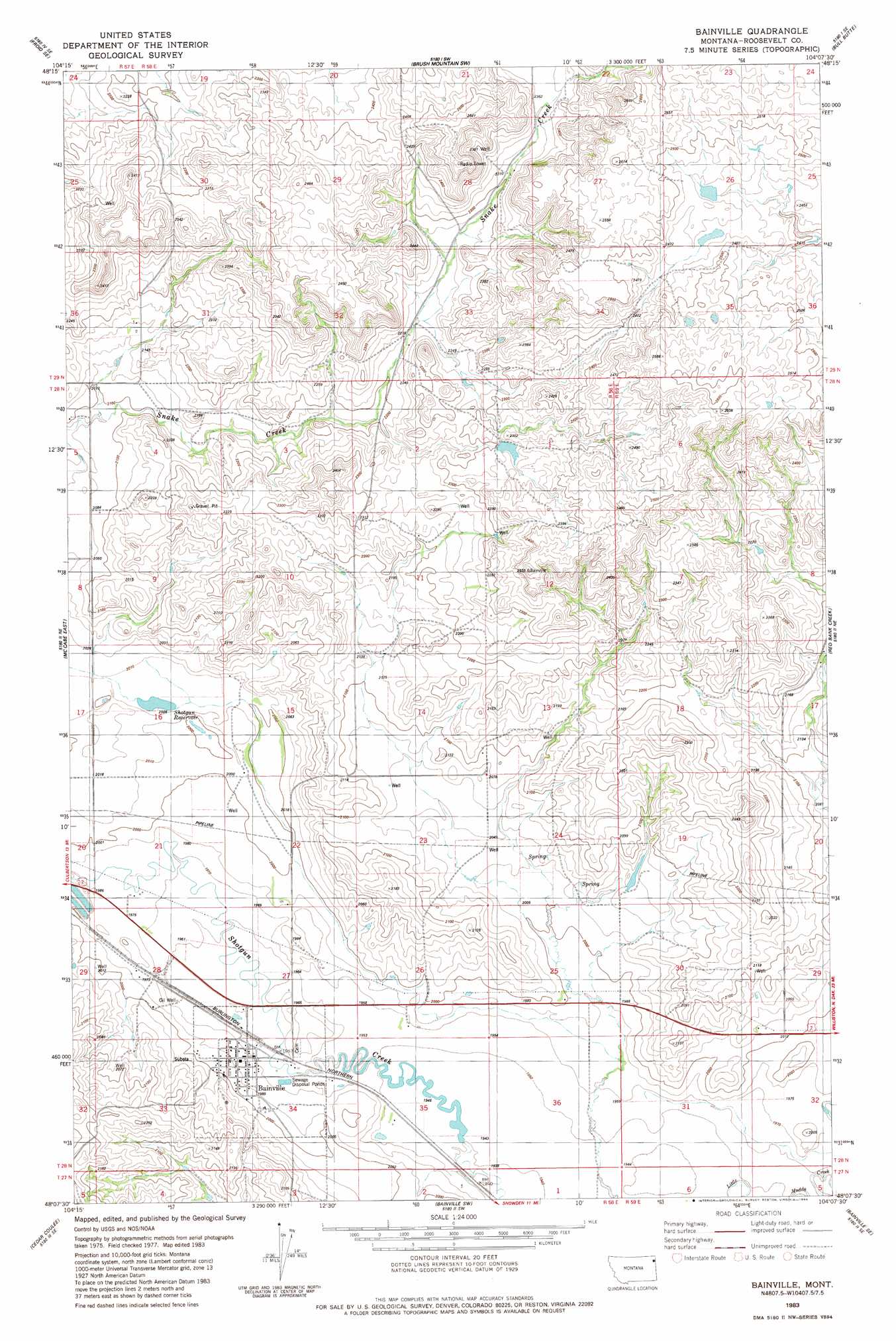
USGS Topo Quad 48104b2 - 1:24,000 scale
| Topo Map Name: | Bainville |
| USGS Topo Quad ID: | 48104b2 |
| Print Size: | ca. 21 1/4" wide x 27" high |
| Southeast Coordinates: | 48.125° N latitude / 104.125° W longitude |
| Map Center Coordinates: | 48.1875° N latitude / 104.1875° W longitude |
| U.S. State: | MT |
| Filename: | o48104b2.jpg |
| Download Map JPG Image: | Bainville topo map 1:24,000 scale |
| Map Type: | Topographic |
| Topo Series: | 7.5´ |
| Map Scale: | 1:24,000 |
| Source of Map Images: | United States Geological Survey (USGS) |
| Alternate Map Versions: |
Bainville MT 1983, updated 1984 Download PDF Buy paper map Bainville MT 2011 Download PDF Buy paper map Bainville MT 2014 Download PDF Buy paper map |
1:24,000 Topo Quads surrounding Bainville
Medicine Lake |
Capeneys Lake |
Sunnyhill School |
Brush Mountain |
West Bonetraill |
Froid |
Froid Se |
Brush Mountain Sw |
Bull Butte |
Bonetraill Sw |
Mccabe West |
Mccabe East |
Bainville |
Red Bank Creek |
Trenton Nw |
Three Buttes |
Cedar Coulee |
Bainville Sw |
Bainville Se |
Trenton Sw |
Blue Hill |
Sioux Pass |
Fairview Nw |
Dore |
Buford |
> Back to 48104a1 at 1:100,000 scale
> Back to 48104a1 at 1:250,000 scale
> Back to U.S. Topo Maps home
Bainville topo map: Gazetteer
Bainville: Dams
Crusch Pond Dam elevation 708m 2322′Feisty Dam elevation 621m 2037′
Wilde Dam elevation 634m 2080′
Bainville: Parks
Fort Union Historical Marker elevation 603m 1978′Bainville: Populated Places
Bainville elevation 602m 1975′Bainville: Post Offices
Bainville Post Office elevation 598m 1961′Bainville: Reservoirs
Shotgun Reservoir elevation 613m 2011′Bainville: Wells
27N58E02AA__01 Well elevation 592m 1942′27N58E02AA__02 Well elevation 592m 1942′
27N58E03AA__01 Well elevation 617m 2024′
27N58E03AB__01 Well elevation 624m 2047′
27N58E03AB__02 Well elevation 624m 2047′
28N58E04BA__01 Well elevation 642m 2106′
28N58E04CC__01 Well elevation 641m 2103′
28N58E04CC__02 Well elevation 641m 2103′
28N58E05AD__01 Well elevation 636m 2086′
28N58E05AD__02 Well elevation 636m 2086′
28N58E05DD__01 Well elevation 634m 2080′
28N58E13CADD01 Well elevation 652m 2139′
28N58E14DD__01 Well elevation 639m 2096′
28N58E15BB__01 Well elevation 621m 2037′
28N58E15BD__01 Well elevation 620m 2034′
28N58E15CA__01 Well elevation 612m 2007′
28N58E20DA__01 Well elevation 604m 1981′
28N58E21CD__01 Well elevation 602m 1975′
28N58E22CD__01 Well elevation 606m 1988′
28N58E22DC__01 Well elevation 607m 1991′
28N58E24CA__01 Well elevation 623m 2043′
28N58E24DC__01 Well elevation 616m 2020′
28N58E25DB__01 Well elevation 605m 1984′
28N58E26CD__01 Well elevation 603m 1978′
28N58E26CD__02 Well elevation 603m 1978′
28N58E26CD__03 Well elevation 603m 1978′
28N58E26CDCD01 Well elevation 597m 1958′
28N58E27ACDD01 Well elevation 601m 1971′
28N58E28BC__01 Well elevation 604m 1981′
28N58E29AA__01 Well elevation 604m 1981′
28N58E33AA__01 Well elevation 605m 1984′
28N58E34BA__01 Well elevation 598m 1961′
28N58E34BB__01 Well elevation 597m 1958′
28N58E34BB__02 Well elevation 597m 1958′
28N58E34BD__01 Well elevation 598m 1961′
28N58E34BD__02 Well elevation 598m 1961′
28N58E35CA__01 Well elevation 593m 1945′
28N59E17BA__01 Well elevation 664m 2178′
28N59E17BA__02 Well elevation 664m 2178′
28N59E17BA__03 Well elevation 664m 2178′
28N59E17CC__01 Well elevation 641m 2103′
28N59E19CC__01 Well elevation 627m 2057′
28N59E29CBBB01 Well elevation 650m 2132′
28N59E29CC__01 Well elevation 617m 2024′
28N59E29CC__02 Well elevation 617m 2024′
28N59E30AC__01 Well elevation 640m 2099′
29N57E25DBDA01 Well elevation 677m 2221′
29N58E28ABCD01 Well elevation 765m 2509′
Bainville digital topo map on disk
Buy this Bainville topo map showing relief, roads, GPS coordinates and other geographical features, as a high-resolution digital map file on DVD:
Eastern Montana & Western North Dakota
Buy digital topo maps: Eastern Montana & Western North Dakota