Brockton Topo Map Montana
To zoom in, hover over the map of Brockton
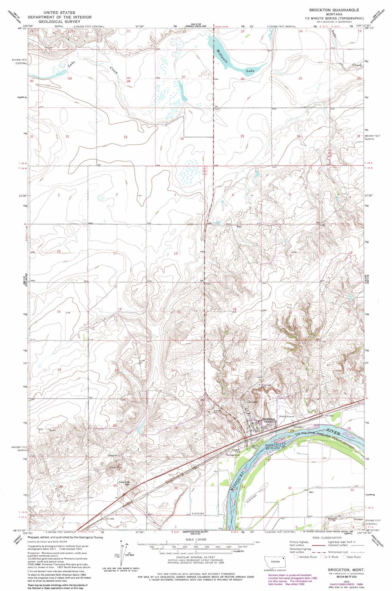
USGS Topo Quad 48104b8 - 1:24,000 scale
| Topo Map Name: | Brockton |
| USGS Topo Quad ID: | 48104b8 |
| Print Size: | ca. 21 1/4" wide x 27" high |
| Southeast Coordinates: | 48.125° N latitude / 104.875° W longitude |
| Map Center Coordinates: | 48.1875° N latitude / 104.9375° W longitude |
| U.S. State: | MT |
| Filename: | o48104b8.jpg |
| Download Map JPG Image: | Brockton topo map 1:24,000 scale |
| Map Type: | Topographic |
| Topo Series: | 7.5´ |
| Map Scale: | 1:24,000 |
| Source of Map Images: | United States Geological Survey (USGS) |
| Alternate Map Versions: |
Brockton MT 1972, updated 1975 Download PDF Buy paper map Brockton MT 1972, updated 1989 Download PDF Buy paper map Brockton MT 2011 Download PDF Buy paper map Brockton MT 2014 Download PDF Buy paper map |
1:24,000 Topo Quads surrounding Brockton
Hay Creek Nw |
Hay Creek |
Beam School |
Smoke Creek Ne |
Homestead Nw |
Long Creek East |
Geddart Lake |
Smoke Creek Sw |
Coyote Coulee |
Rocky Point |
Badger Creek |
Poplar Ne |
Brockton |
Calais |
Fort Kipp |
Poplar |
Sprole |
Mortarstone Bluff |
Frog Coulee |
Twomile Creek |
Sullivan Coulee |
Duplisse Creek North |
Elmdale Nw |
Elmdale |
Elm Coulee |
> Back to 48104a1 at 1:100,000 scale
> Back to 48104a1 at 1:250,000 scale
> Back to U.S. Topo Maps home
Brockton topo map: Gazetteer
Brockton: Lakes
McIlwain Lake elevation 614m 2014′Brockton: Populated Places
Brockton elevation 605m 1984′Brockton: Post Offices
Brockton Post Office elevation 601m 1971′Brockton: Summits
Twomile Hill elevation 616m 2020′Brockton: Wells
27N52E01BC__01 Well elevation 593m 1945′27N52E01BC__02 Well elevation 593m 1945′
27N52E02AA__01 Well elevation 594m 1948′
27N52E02AC__01 Well elevation 594m 1948′
27N53E04BB__01 Well elevation 592m 1942′
27N53E04BB__02 Well elevation 592m 1942′
27N53E04BB__03 Well elevation 592m 1942′
27N53E06BA__01 Well elevation 589m 1932′
28N52E11CCCC01 Well elevation 633m 2076′
28N52E13AACA01 Well elevation 645m 2116′
28N52E14ADDA01 Well elevation 639m 2096′
28N52E15DD__01 Well elevation 640m 2099′
28N52E15DDAA01 Well elevation 641m 2103′
28N52E23CD__01 Well elevation 659m 2162′
28N52E23CD__02 Well elevation 659m 2162′
28N52E25CA__01 Well elevation 634m 2080′
28N52E34CD__01 Well elevation 610m 2001′
28N52E34DD__02 Well elevation 600m 1968′
28N53E06BBAB01 Well elevation 621m 2037′
28N53E19BCCB01 Well elevation 646m 2119′
28N53E19CD__01 Well elevation 637m 2089′
28N53E20DC__01 Well elevation 629m 2063′
28N53E29BC__01 Well elevation 606m 1988′
28N53E29BC__02 Well elevation 606m 1988′
28N53E29CB__01 Well elevation 601m 1971′
28N53E29CB__02 Well elevation 601m 1971′
28N53E29DC__01 Well elevation 589m 1932′
28N53E30AD__01 Well elevation 620m 2034′
28N53E30AD__02 Well elevation 620m 2034′
28N53E30AD__03 Well elevation 620m 2034′
28N53E30AD__04 Well elevation 620m 2034′
28N53E30AD__05 Well elevation 620m 2034′
28N53E30AD__06 Well elevation 620m 2034′
28N53E30AD__07 Well elevation 620m 2034′
28N53E30AD__08 Well elevation 620m 2034′
28N53E30DA__01 Well elevation 602m 1975′
28N53E30DA__02 Well elevation 602m 1975′
28N53E30DA__03 Well elevation 602m 1975′
28N53E30DA__04 Well elevation 602m 1975′
28N53E30DA__05 Well elevation 602m 1975′
28N53E30DA__06 Well elevation 602m 1975′
28N53E30DA__07 Well elevation 602m 1975′
28N53E30DA__08 Well elevation 602m 1975′
28N53E30DB__01 Well elevation 610m 2001′
28N53E30DD__01 Well elevation 595m 1952′
28N53E30DDBB01 Well elevation 596m 1955′
28N53E31BB__01 Well elevation 600m 1968′
28N53E32AD__01 Well elevation 588m 1929′
28N53E32AD__02 Well elevation 588m 1929′
28N53E32BC__01 Well elevation 588m 1929′
28N53E32DA__01 Well elevation 589m 1932′
28N53E32DABC01 Well elevation 589m 1932′
28N53E33CD__01 Well elevation 588m 1929′
28N53E33CD__02 Well elevation 588m 1929′
29N52E27DADC01 Well elevation 617m 2024′
29N52E27DADC02 Well elevation 617m 2024′
29N52E34BCAC01 Well elevation 624m 2047′
29N52E35CBBB02 Well elevation 621m 2037′
Brockton digital topo map on disk
Buy this Brockton topo map showing relief, roads, GPS coordinates and other geographical features, as a high-resolution digital map file on DVD:
Eastern Montana & Western North Dakota
Buy digital topo maps: Eastern Montana & Western North Dakota