Sprole Topo Map Montana
To zoom in, hover over the map of Sprole
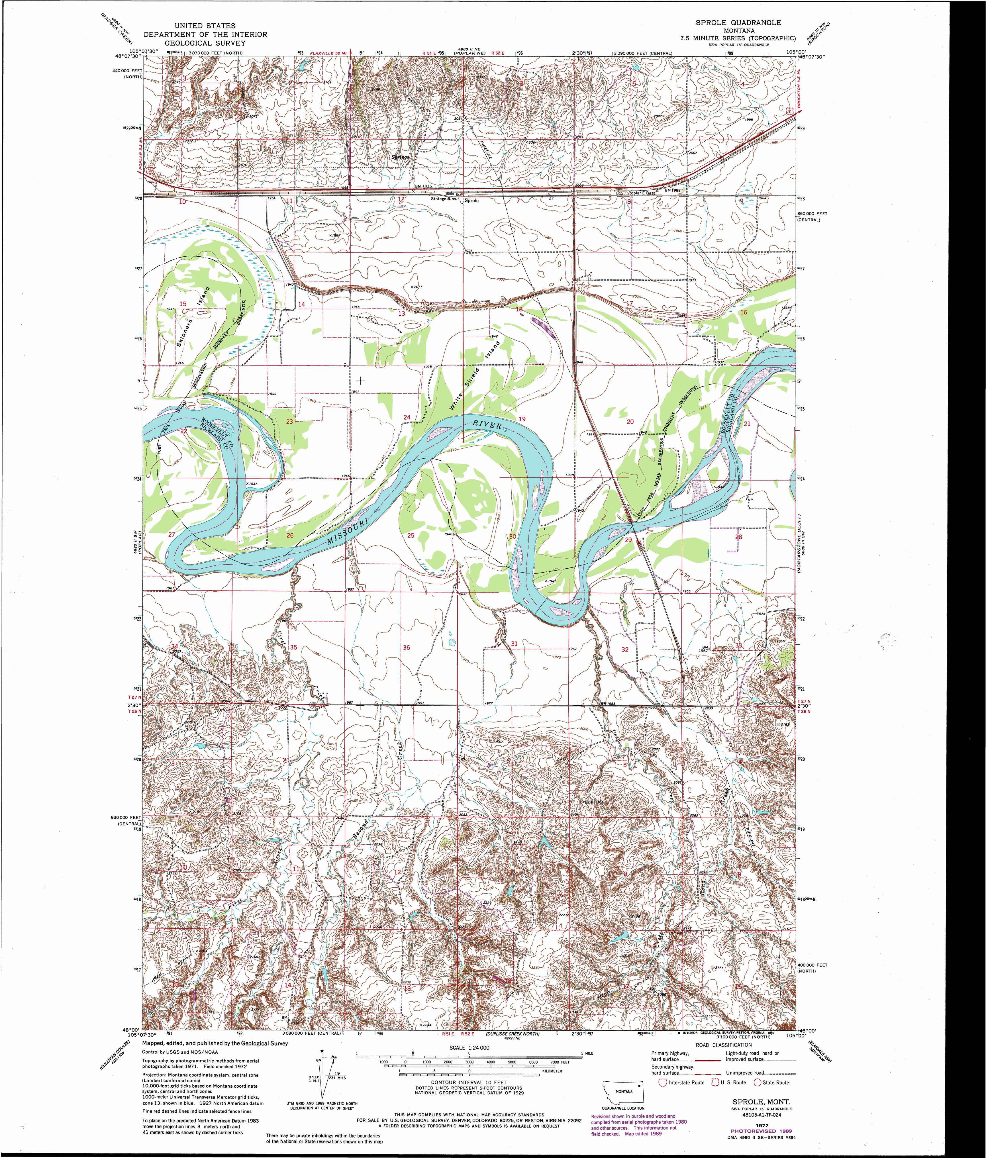
USGS Topo Quad 48105a1 - 1:24,000 scale
| Topo Map Name: | Sprole |
| USGS Topo Quad ID: | 48105a1 |
| Print Size: | ca. 21 1/4" wide x 27" high |
| Southeast Coordinates: | 48° N latitude / 105° W longitude |
| Map Center Coordinates: | 48.0625° N latitude / 105.0625° W longitude |
| U.S. State: | MT |
| Filename: | o48105a1.jpg |
| Download Map JPG Image: | Sprole topo map 1:24,000 scale |
| Map Type: | Topographic |
| Topo Series: | 7.5´ |
| Map Scale: | 1:24,000 |
| Source of Map Images: | United States Geological Survey (USGS) |
| Alternate Map Versions: |
Sprole MT 1972, updated 1976 Download PDF Buy paper map Sprole MT 1972, updated 1988 Download PDF Buy paper map Sprole MT 2011 Download PDF Buy paper map Sprole MT 2014 Download PDF Buy paper map |
1:24,000 Topo Quads surrounding Sprole
Long Creek West |
Long Creek East |
Geddart Lake |
Smoke Creek Sw |
Coyote Coulee |
Chelsea |
Badger Creek |
Poplar Ne |
Brockton |
Calais |
Nickwall |
Poplar |
Sprole |
Mortarstone Bluff |
Frog Coulee |
Dowse Coulee |
Sullivan Coulee |
Duplisse Creek North |
Elmdale Nw |
Elmdale |
Kraut Coulee |
Lisk Creek |
Duplisse Creek South |
Elmdale Sw |
Carda Coulee |
> Back to 48105a1 at 1:100,000 scale
> Back to 48104a1 at 1:250,000 scale
> Back to U.S. Topo Maps home
Sprole topo map: Gazetteer
Sprole: Bridges
Poplar Bridge elevation 588m 1929′Sprole: Dams
Davis Dam elevation 601m 1971′Sprole: Islands
Skinners Island elevation 595m 1952′White Shield Island elevation 592m 1942′
Sprole: Populated Places
Deertail Indian Village (historical) elevation 592m 1942′Sprole elevation 604m 1981′
Sprole: Streams
Bilger Creek elevation 613m 2011′Colgan Creek elevation 591m 1938′
Deep Creek elevation 589m 1932′
First Creek elevation 593m 1945′
Renz Creek elevation 595m 1952′
Second Creek elevation 595m 1952′
Sprole: Wells
26N48E15BCCC01 Well elevation 662m 2171′26N51E02AABA01 Well elevation 607m 1991′
26N51E13AA__01 Well elevation 651m 2135′
26N51E13AA__02 Well elevation 651m 2135′
26N52E05ACCB01 Well elevation 609m 1998′
26N52E05BA__01 Well elevation 608m 1994′
26N52E05CA__01 Well elevation 624m 2047′
26N52E06CD__01 Well elevation 642m 2106′
27N51E10DA__01 Well elevation 597m 1958′
27N51E10DB__01 Well elevation 595m 1952′
27N51E11CC__01 Well elevation 594m 1948′
27N51E11CD__01 Well elevation 595m 1952′
27N51E12AB__01 Well elevation 615m 2017′
27N51E13CB__01 Well elevation 593m 1945′
27N51E14BD__01 Well elevation 592m 1942′
27N51E25DD__01 Well elevation 592m 1942′
27N51E26DD__01 Well elevation 596m 1955′
27N51E35DD__01 Well elevation 606m 1988′
27N52E07CD__01 Well elevation 610m 2001′
27N52E07DA__01 Well elevation 609m 1998′
27N52E07DABB01 Well elevation 608m 1994′
27N52E07DABB02 Well elevation 608m 1994′
27N52E08AC__01 Well elevation 611m 2004′
27N52E08DA__01 Well elevation 607m 1991′
27N52E09AC__01 Well elevation 598m 1961′
27N52E09AD__01 Well elevation 598m 1961′
27N52E09BB__01 Well elevation 610m 2001′
27N52E09DC__01 Well elevation 600m 1968′
27N52E16AD__01 Well elevation 591m 1938′
27N52E16BA__01 Well elevation 598m 1961′
27N52E17BB__01 Well elevation 604m 1981′
27N52E17CB__01 Well elevation 592m 1942′
27N52E18AB__01 Well elevation 608m 1994′
27N52E18AD__01 Well elevation 608m 1994′
27N52E18CA__01 Well elevation 592m 1942′
27N52E28AB__01 Well elevation 591m 1938′
27N52E28AB__02 Well elevation 591m 1938′
27N52E28AB__03 Well elevation 591m 1938′
27N52E28BA__01 Well elevation 588m 1929′
27N52E31CA__01 Well elevation 598m 1961′
27N52E32AD__01 Well elevation 600m 1968′
27N52E32CC__01 Well elevation 605m 1984′
Sprole digital topo map on disk
Buy this Sprole topo map showing relief, roads, GPS coordinates and other geographical features, as a high-resolution digital map file on DVD:
Eastern Montana & Western North Dakota
Buy digital topo maps: Eastern Montana & Western North Dakota