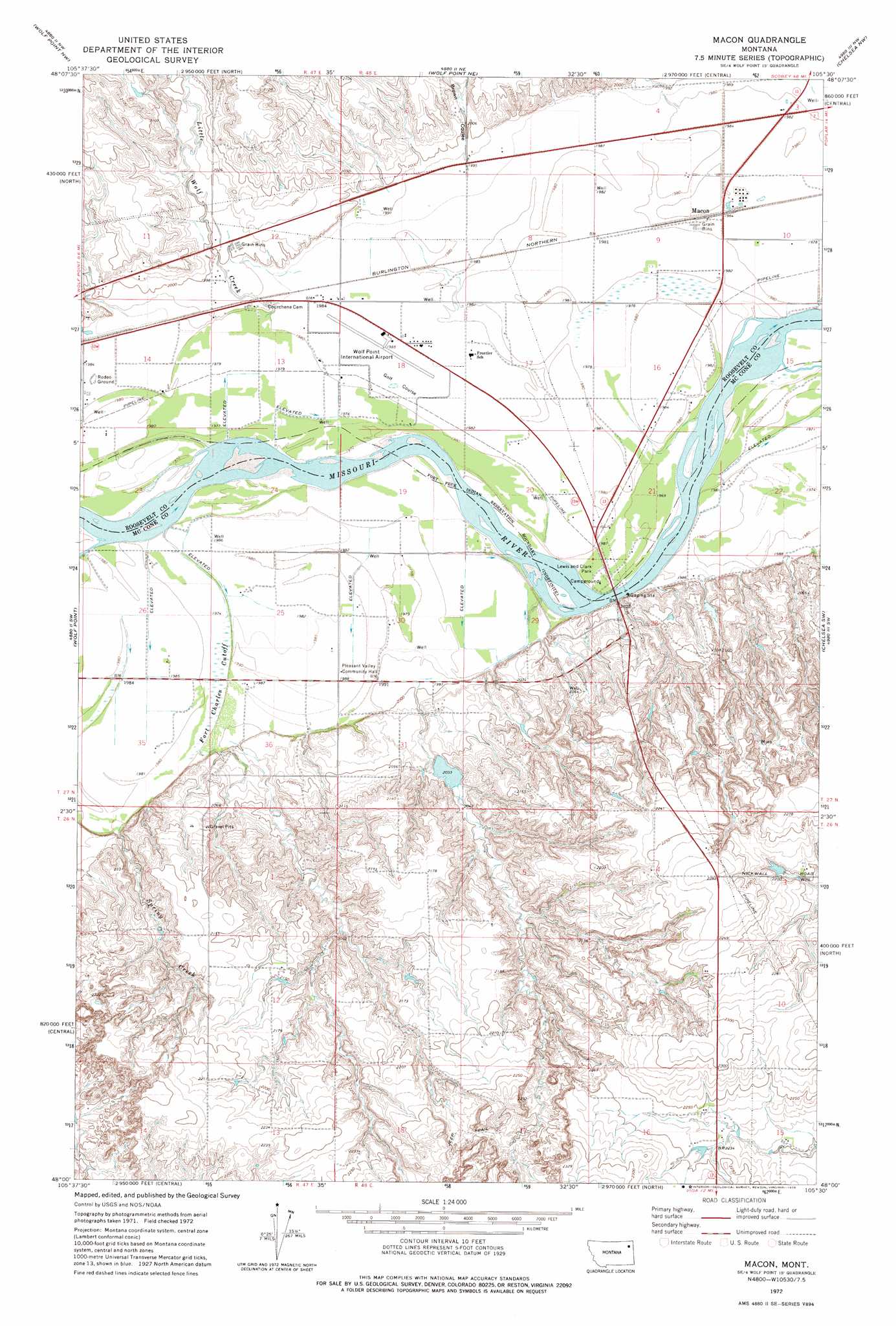
Macon Topo Map Montana
To zoom in, hover over the map of Macon
USGS Topo Quad 48105a5 - 1:24,000 scale
| Topo Map Name: | Macon |
| USGS Topo Quad ID: | 48105a5 |
| Print Size: | ca. 21 1/4" wide x 27" high |
| Southeast Coordinates: | 48° N latitude / 105.5° W longitude |
| Map Center Coordinates: | 48.0625° N latitude / 105.5625° W longitude |
| U.S. State: | MT |
| Filename: | o48105a5.jpg |
| Download Map JPG Image: | Macon topo map 1:24,000 scale |
| Map Type: | Topographic |
| Topo Series: | 7.5´ |
| Map Scale: | 1:24,000 |
| Source of Map Images: | United States Geological Survey (USGS) |
| Alternate Map Versions: |
Macon MT 1972, updated 1975 Download PDF Buy paper map Macon MT 2011 Download PDF Buy paper map Macon MT 2014 Download PDF Buy paper map |
1:24,000 Topo Quads surrounding Macon
Todd Lakes Se |
Tule Valley West |
Tule Valley East |
Sims Spring |
Long Creek West |
Flynn Creek North |
Wolf Point Nw |
Wolf Point Ne |
Chelsea Nw |
Chelsea |
Flynn Creek South |
Wolf Point |
Macon |
Chelsea Sw |
Nickwall |
Emily Coulee |
Antelope Creek Res. |
Rock Creek |
Gady Coulee |
Dowse Coulee |
Sadie Coulee |
Dailey Spring |
Lone Pine School |
Vida |
Kraut Coulee |
> Back to 48105a1 at 1:100,000 scale
> Back to 48104a1 at 1:250,000 scale
> Back to U.S. Topo Maps home
Macon topo map: Gazetteer
Macon: Airports
Lyman Clayton Airport elevation 605m 1984′Vine Airport elevation 632m 2073′
Macon: Bridges
Lewis and Clark Bridge elevation 599m 1965′Macon: Canals
Fort Charles Cutoff elevation 604m 1981′Macon: Dams
Balder Reservoir Dam elevation 620m 2034′Macon: Parks
Lewis and Clark Park elevation 603m 1978′Macon: Populated Places
Macon elevation 604m 1981′Pleasant Valley (historical) elevation 606m 1988′
Macon: Streams
Little Wolf Creek elevation 604m 1981′Spring Creek elevation 604m 1981′
U P Creek elevation 606m 1988′
Macon: Valleys
Brown Coulee elevation 607m 1991′Macon: Wells
26N48E09ACA_01 Well elevation 693m 2273′26N48E15BCCC01 Well elevation 678m 2224′
27N47E11CC__01 Well elevation 613m 2011′
27N47E11CC__02 Well elevation 613m 2011′
27N47E12CC__01 Well elevation 607m 1991′
27N47E12CC__02 Well elevation 607m 1991′
27N47E13AB__01 Well elevation 605m 1984′
27N47E13AB__02 Well elevation 605m 1984′
27N47E13BA__01 Well elevation 608m 1994′
27N47E13BA__02 Well elevation 608m 1994′
27N47E13BA__03 Well elevation 608m 1994′
27N47E13BA__04 Well elevation 608m 1994′
27N47E13BB__01 Well elevation 607m 1991′
27N47E13CB__01 Well elevation 603m 1978′
27N47E13DA__01 Well elevation 604m 1981′
27N47E13DA__02 Well elevation 604m 1981′
27N47E14AA__01 Well elevation 607m 1991′
27N47E14BB__01 Well elevation 607m 1991′
27N47E14CB__01 Well elevation 605m 1984′
27N47E14CB__02 Well elevation 605m 1984′
27N47E14CB__03 Well elevation 605m 1984′
27N47E14CB__04 Well elevation 605m 1984′
27N47E14CC__01 Well elevation 604m 1981′
27N47E14DA__01 Well elevation 604m 1981′
27N47E23BB__01 Well elevation 604m 1981′
27N47E23DD__01 Well elevation 605m 1984′
27N47E24CA__01 Well elevation 601m 1971′
27N47E24CC__01 Well elevation 606m 1988′
27N47E25BA__01 Well elevation 604m 1981′
27N47E25DD__01 Well elevation 606m 1988′
27N47E25DD__02 Well elevation 606m 1988′
27N47E26DC__01 Well elevation 605m 1984′
27N47E35AB__01 Well elevation 605m 1984′
27N47E35BA__01 Well elevation 605m 1984′
27N47E35DB__01 Well elevation 604m 1981′
27N47E36AD__01 Well elevation 605m 1984′
27N48E03DC__01 Well elevation 604m 1981′
27N48E04DACB01 Well elevation 604m 1981′
27N48E04DACC01 Well elevation 604m 1981′
27N48E05CC__01 Well elevation 607m 1991′
27N48E05CC__02 Well elevation 607m 1991′
27N48E06DA__01 Well elevation 617m 2024′
27N48E09AD__01 Well elevation 604m 1981′
27N48E09DC__01 Well elevation 604m 1981′
27N48E10BD__02 Well elevation 604m 1981′
27N48E10CB__01 Well elevation 604m 1981′
27N48E10CB__02 Well elevation 604m 1981′
27N48E10CB__03 Well elevation 604m 1981′
27N48E10DB__01 Well elevation 604m 1981′
27N48E15CA__01 Well elevation 599m 1965′
27N48E16DB__01 Well elevation 604m 1981′
27N48E17BA__01 Well elevation 604m 1981′
27N48E17BA__02 Well elevation 604m 1981′
27N48E17CD__01 Well elevation 605m 1984′
27N48E17DD__01 Well elevation 604m 1981′
27N48E18DD__01 Well elevation 605m 1984′
27N48E19DB__01 Well elevation 603m 1978′
27N48E19DB__02 Well elevation 603m 1978′
27N48E20CC__01 Well elevation 600m 1968′
27N48E20CCCA01 Well elevation 603m 1978′
27N48E20DC__01 Well elevation 604m 1981′
27N48E21CC__01 Well elevation 604m 1981′
27N48E22BB__01 Well elevation 601m 1971′
27N48E22BC__01 Well elevation 602m 1975′
27N48E27ACAA01 Well elevation 630m 2066′
27N48E27BA__01 Well elevation 606m 1988′
27N48E28AA__01 Well elevation 604m 1981′
27N48E28BB__01 Well elevation 604m 1981′
27N48E28BB__02 Well elevation 604m 1981′
27N48E28BB__03 Well elevation 604m 1981′
27N48E28BD__01 Well elevation 607m 1991′
27N48E30BC__01 Well elevation 604m 1981′
27N48E30CC__01 Well elevation 605m 1984′
27N48E30DB__01 Well elevation 604m 1981′
27N48E31BC__01 Well elevation 605m 1984′
27N48E31CA__01 Well elevation 621m 2037′
27N48E32BA__01 Well elevation 616m 2020′
Macon digital topo map on disk
Buy this Macon topo map showing relief, roads, GPS coordinates and other geographical features, as a high-resolution digital map file on DVD:
Eastern Montana & Western North Dakota
Buy digital topo maps: Eastern Montana & Western North Dakota