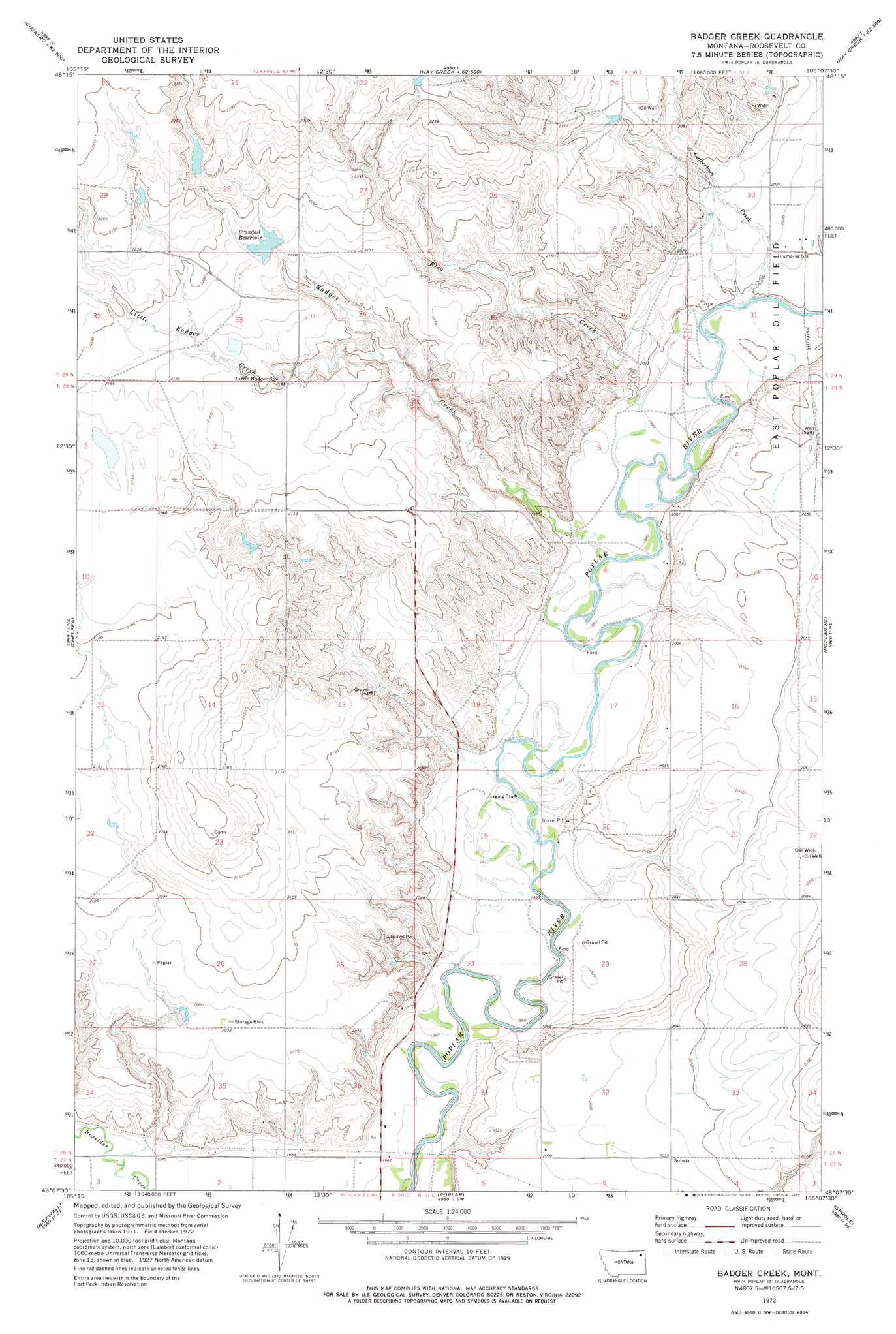
Badger Creek Topo Map Montana
To zoom in, hover over the map of Badger Creek
USGS Topo Quad 48105b2 - 1:24,000 scale
| Topo Map Name: | Badger Creek |
| USGS Topo Quad ID: | 48105b2 |
| Print Size: | ca. 21 1/4" wide x 27" high |
| Southeast Coordinates: | 48.125° N latitude / 105.125° W longitude |
| Map Center Coordinates: | 48.1875° N latitude / 105.1875° W longitude |
| U.S. State: | MT |
| Filename: | o48105b2.jpg |
| Download Map JPG Image: | Badger Creek topo map 1:24,000 scale |
| Map Type: | Topographic |
| Topo Series: | 7.5´ |
| Map Scale: | 1:24,000 |
| Source of Map Images: | United States Geological Survey (USGS) |
| Alternate Map Versions: |
Badger Creek MT 1972, updated 1975 Download PDF Buy paper map Badger Creek MT 2011 Download PDF Buy paper map Badger Creek MT 2014 Download PDF Buy paper map |
1:24,000 Topo Quads surrounding Badger Creek
Bears Nest |
Windy Butte |
Hay Creek Nw |
Hay Creek |
Beam School |
Sims Spring |
Long Creek West |
Long Creek East |
Geddart Lake |
Smoke Creek Sw |
Chelsea Nw |
Chelsea |
Badger Creek |
Poplar Ne |
Brockton |
Chelsea Sw |
Nickwall |
Poplar |
Sprole |
Mortarstone Bluff |
Gady Coulee |
Dowse Coulee |
Sullivan Coulee |
Duplisse Creek North |
Elmdale Nw |
> Back to 48105a1 at 1:100,000 scale
> Back to 48104a1 at 1:250,000 scale
> Back to U.S. Topo Maps home
Badger Creek topo map: Gazetteer
Badger Creek: Dams
Barney Rubbel Dam elevation 678m 2224′Clark Pond Number 2 Dam elevation 686m 2250′
Crandall Reservoir Dam elevation 663m 2175′
Structure Number 137 Dam elevation 631m 2070′
Badger Creek: Reservoirs
Crandall Reservoir elevation 663m 2175′Structure Number 139 Reservoir elevation 663m 2175′
Badger Creek: Springs
29N50E33DDCC01 Spring elevation 656m 2152′29N51E19DDBA01 Spring elevation 623m 2043′
29N51E30DDDD01 Spring elevation 611m 2004′
Little Badger Spring elevation 652m 2139′
Badger Creek: Streams
Badger Creek elevation 604m 1981′Culbertson Creek elevation 607m 1991′
Flea Creek elevation 604m 1981′
Little Badger Creek elevation 638m 2093′
Badger Creek: Wells
27N50E02BB__01 Well elevation 602m 1975′27N50E03AA__01 Well elevation 600m 1968′
27N50E03AD__01 Well elevation 600m 1968′
27N50E03AD__02 Well elevation 600m 1968′
28N50E02AD__01 Well elevation 660m 2165′
28N50E12AB__01 Well elevation 654m 2145′
28N50E25DDDA01 Well elevation 598m 1961′
28N50E26DC__01 Well elevation 636m 2086′
28N50E34DCAC01 Well elevation 600m 1968′
28N50E35CD__01 Well elevation 617m 2024′
28N50E36AAAA01 Well elevation 616m 2020′
28N50E36AAAA02 Well elevation 598m 1961′
28N50E36DD__01 Well elevation 599m 1965′
28N50E36DDCA01 Well elevation 599m 1965′
28N51E04CCCD01 Well elevation 615m 2017′
28N51E08AAAC01 Well elevation 609m 1998′
28N51E08ADDA01 Well elevation 608m 1994′
28N51E08BACC01 Well elevation 607m 1991′
28N51E08BACC02 Well elevation 607m 1991′
28N51E08BBDA01 Well elevation 607m 1991′
28N51E08BBDB01 Well elevation 608m 1994′
28N51E08BDBA01 Well elevation 606m 1988′
28N51E08BDBA02 Well elevation 606m 1988′
28N51E08CCBB01 Well elevation 602m 1975′
28N51E08CCBC01 Well elevation 603m 1978′
28N51E08CCBC02 Well elevation 604m 1981′
28N51E08DDDB01 Well elevation 619m 2030′
28N51E09BCBB01 Well elevation 623m 2043′
28N51E09CCDD01 Well elevation 621m 2037′
28N51E09CDBB01 Well elevation 617m 2024′
28N51E09DCCC01 Well elevation 622m 2040′
28N51E16DBCB01 Well elevation 623m 2043′
28N51E17AABA01 Well elevation 609m 1998′
28N51E17AABB01 Well elevation 608m 1994′
28N51E17ABDC01 Well elevation 602m 1975′
28N51E17ABDC02 Well elevation 603m 1978′
28N51E17ABDD01 Well elevation 608m 1994′
28N51E17ABDD02 Well elevation 608m 1994′
28N51E17ADAD01 Well elevation 619m 2030′
28N51E17DADA01 Well elevation 617m 2024′
28N51E17DDAD01 Well elevation 617m 2024′
28N51E18ABDC01 Well elevation 609m 1998′
28N51E19AB__01 Well elevation 601m 1971′
28N51E21BDBC01 Well elevation 616m 2020′
28N51E22BBBB01 Well elevation 630m 2066′
28N51E22CBCB01 Well elevation 635m 2083′
28N51E22CBCB02 Well elevation 635m 2083′
28N51E27BBBB01 Well elevation 637m 2089′
28N51E29BACA01 Well elevation 600m 1968′
28N51E29CACB01 Well elevation 602m 1975′
28N51E32CCCB01 Well elevation 617m 2024′
28N51E32DCCC01 Well elevation 619m 2030′
28N51E33BBBB01 Well elevation 623m 2043′
28N51E33BBBC01 Well elevation 623m 2043′
28N51E33BBBC02 Well elevation 623m 2043′
28N51E33CBAA01 Well elevation 625m 2050′
28N51E33DDCC01 Well elevation 634m 2080′
28N51E33DDCC02 Well elevation 633m 2076′
28N51E33DDCC03 Well elevation 633m 2076′
28N51E33DDCC04 Well elevation 633m 2076′
28N51E33DDCC05 Well elevation 633m 2076′
29N51E19DCAC01 Well elevation 627m 2057′
29N51E31ABDD01 Well elevation 611m 2004′
29N51E31BDBA01 Well elevation 611m 2004′
29N51E31CABB01 Well elevation 607m 1991′
29N51E31DBAD01 Well elevation 608m 1994′
29N51E31DBDD01 Well elevation 609m 1998′
Badger Creek digital topo map on disk
Buy this Badger Creek topo map showing relief, roads, GPS coordinates and other geographical features, as a high-resolution digital map file on DVD:
Eastern Montana & Western North Dakota
Buy digital topo maps: Eastern Montana & Western North Dakota