Peerless 4 Se Topo Map Montana
To zoom in, hover over the map of Peerless 4 Se
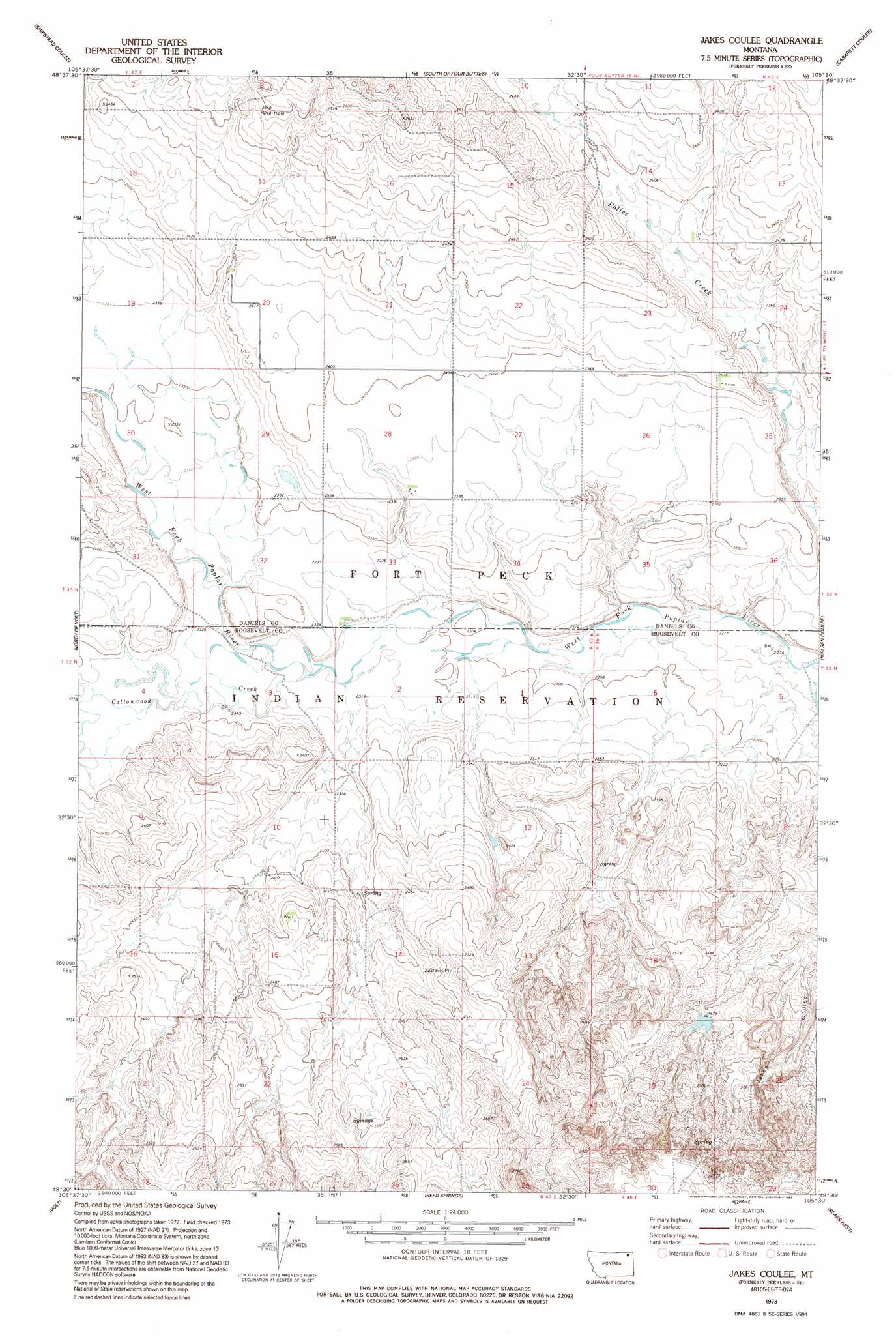
USGS Topo Quad 48105e5 - 1:24,000 scale
| Topo Map Name: | Peerless 4 Se |
| USGS Topo Quad ID: | 48105e5 |
| Print Size: | ca. 21 1/4" wide x 27" high |
| Southeast Coordinates: | 48.5° N latitude / 105.5° W longitude |
| Map Center Coordinates: | 48.5625° N latitude / 105.5625° W longitude |
| U.S. State: | MT |
| Filename: | o48105e5.jpg |
| Download Map JPG Image: | Peerless 4 Se topo map 1:24,000 scale |
| Map Type: | Topographic |
| Topo Series: | 7.5´ |
| Map Scale: | 1:24,000 |
| Source of Map Images: | United States Geological Survey (USGS) |
| Alternate Map Versions: |
Peerless 4 SE MT 1973, updated 1976 Download PDF Buy paper map Jakes Coulee MT 1973, updated 1995 Download PDF Buy paper map Jakes Coulee MT 2011 Download PDF Buy paper map Jakes Coulee MT 2014 Download PDF Buy paper map |
1:24,000 Topo Quads surrounding Peerless 4 Se
Peerless |
Killenbeck Reservoir |
Four Buttes |
Scobey |
Madoc |
West Fork Ne |
Peerless 4 Nw |
Peerless 4 Ne |
Cabarett Coulee |
Line Coulee |
Poplar Coulee |
Peerless 4 Sw |
Peerless 4 Se |
Nielsen Coulee |
Bredette |
Todd Lakes Ne |
Volt |
Reed Springs |
Bears Nest |
Windy Butte |
Todd Lakes Se |
Tule Valley West |
Tule Valley East |
Sims Spring |
Long Creek West |
> Back to 48105e1 at 1:100,000 scale
> Back to 48104a1 at 1:250,000 scale
> Back to U.S. Topo Maps home
Peerless 4 Se topo map: Gazetteer
Peerless 4 Se: Dams
Below Zero Dam elevation 744m 2440′J B and R Haversland Dam elevation 729m 2391′
Peerless 4 Se: Streams
Cottonwood Creek elevation 705m 2312′Peerless 4 Se: Wells
28N47E26DBAD03 Well elevation 744m 2440′33N47E01DBDB01 Well elevation 692m 2270′
33N47E20BDBB01 Well elevation 731m 2398′
Peerless 4 Se digital topo map on disk
Buy this Peerless 4 Se topo map showing relief, roads, GPS coordinates and other geographical features, as a high-resolution digital map file on DVD:
Eastern Montana & Western North Dakota
Buy digital topo maps: Eastern Montana & Western North Dakota