Hewitt Lake Sw Topo Map Montana
To zoom in, hover over the map of Hewitt Lake Sw
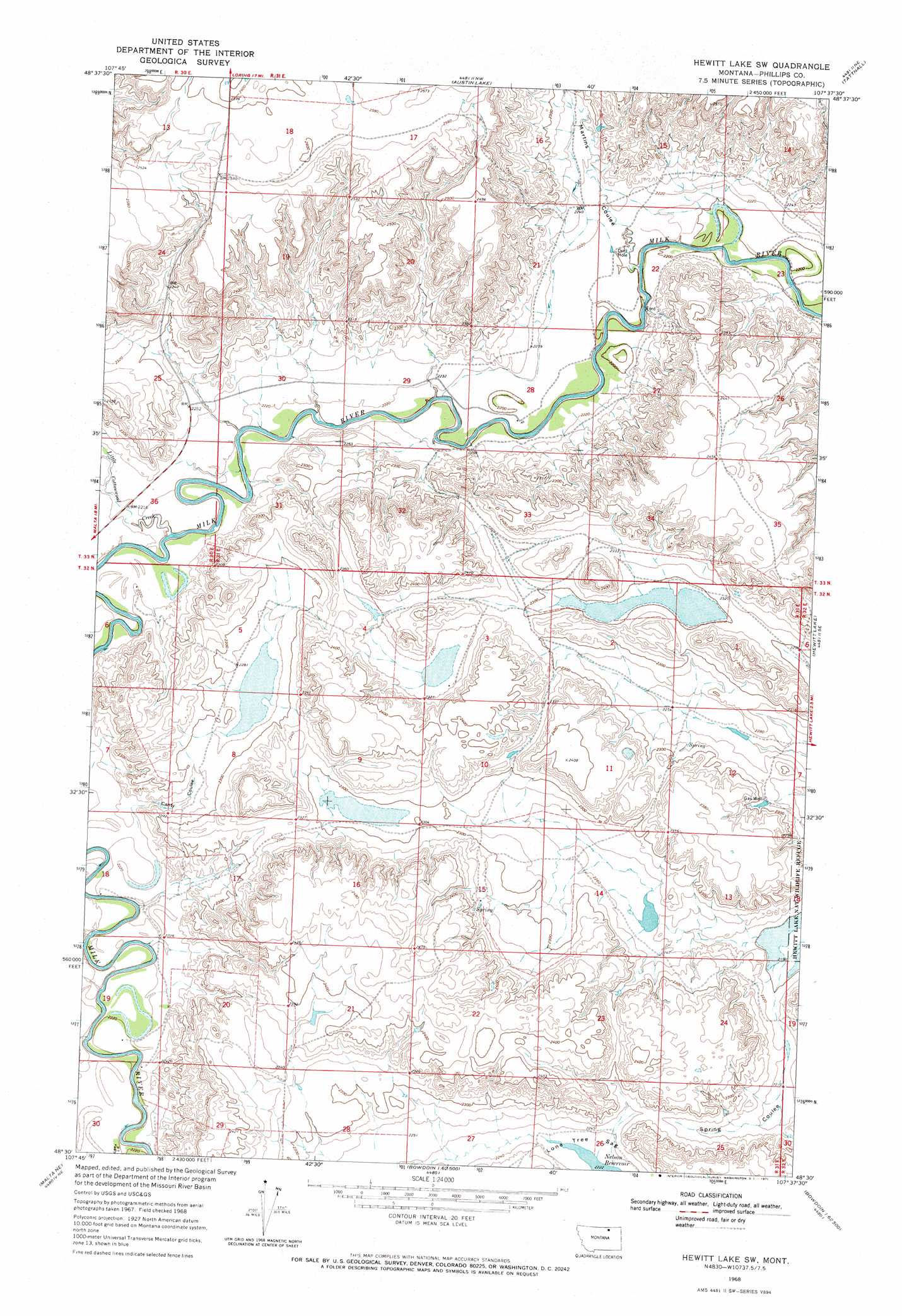
USGS Topo Quad 48107e6 - 1:24,000 scale
| Topo Map Name: | Hewitt Lake Sw |
| USGS Topo Quad ID: | 48107e6 |
| Print Size: | ca. 21 1/4" wide x 27" high |
| Southeast Coordinates: | 48.5° N latitude / 107.625° W longitude |
| Map Center Coordinates: | 48.5625° N latitude / 107.6875° W longitude |
| U.S. State: | MT |
| Filename: | o48107e6.jpg |
| Download Map JPG Image: | Hewitt Lake Sw topo map 1:24,000 scale |
| Map Type: | Topographic |
| Topo Series: | 7.5´ |
| Map Scale: | 1:24,000 |
| Source of Map Images: | United States Geological Survey (USGS) |
| Alternate Map Versions: |
Hewitt Lake SW MT 1968, updated 1971 Download PDF Buy paper map Hewitt Lake SW MT 2011 Download PDF Buy paper map Hewitt Lake SW MT 2014 Download PDF Buy paper map |
1:24,000 Topo Quads surrounding Hewitt Lake Sw
Martin Lake |
Loring |
Whitewater West |
Whitewater East |
Salsbery Reservoir |
Lovejoy |
Austin Coulee |
Austin Lake |
Tattnall |
Forks |
Garland Creek |
Fanny Hill |
Hewitt Lake Sw |
Hewitt Lake |
Cole |
Malta Nw |
Malta Ne |
Lake Bowdoin |
Bowdoin |
Robinson Ranch |
Malta West |
Malta East |
Clanton Coulee |
Pinks |
Regal Coulee |
> Back to 48107e1 at 1:100,000 scale
> Back to 48106a1 at 1:250,000 scale
> Back to U.S. Topo Maps home
Hewitt Lake Sw topo map: Gazetteer
Hewitt Lake Sw: Basins
Lone Tree Sag elevation 681m 2234′Hewitt Lake Sw: Bends
Big Bend elevation 678m 2224′Hewitt Lake Sw: Dams
Bozo Dam elevation 684m 2244′Hewitt Lake Sw: Post Offices
Cowan Post Office (historical) elevation 676m 2217′Newberg Post Office (historical) elevation 672m 2204′
Hewitt Lake Sw: Streams
Little Cottonwood Creek elevation 672m 2204′Hewitt Lake Sw: Valleys
Canty Coulee elevation 677m 2221′Martins Coulee elevation 670m 2198′
Spring Coulee elevation 671m 2201′
Hewitt Lake Sw digital topo map on disk
Buy this Hewitt Lake Sw topo map showing relief, roads, GPS coordinates and other geographical features, as a high-resolution digital map file on DVD:
Eastern Montana & Western North Dakota
Buy digital topo maps: Eastern Montana & Western North Dakota