Lake Seventeen East Topo Map Montana
To zoom in, hover over the map of Lake Seventeen East
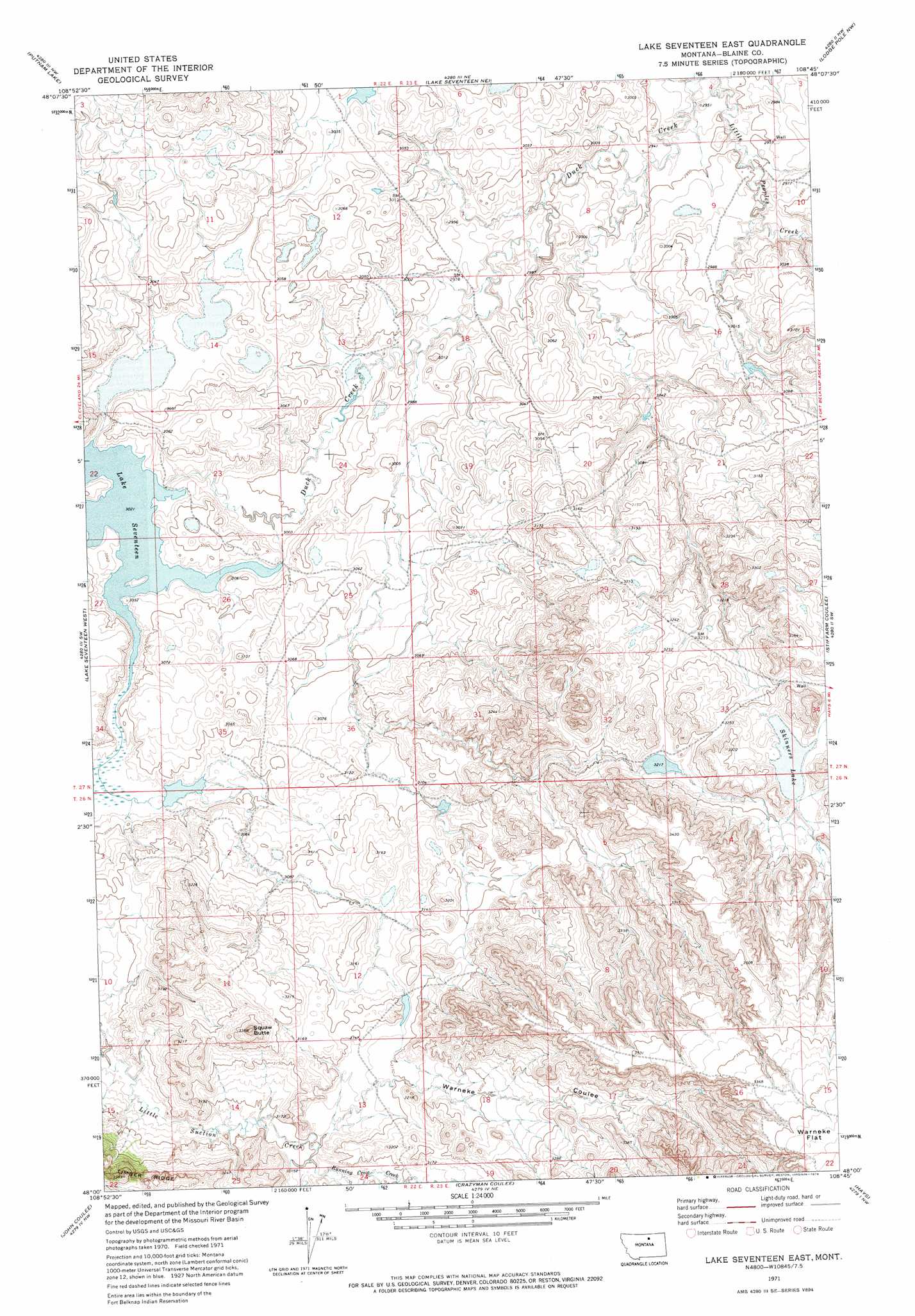
USGS Topo Quad 48108a7 - 1:24,000 scale
| Topo Map Name: | Lake Seventeen East |
| USGS Topo Quad ID: | 48108a7 |
| Print Size: | ca. 21 1/4" wide x 27" high |
| Southeast Coordinates: | 48° N latitude / 108.75° W longitude |
| Map Center Coordinates: | 48.0625° N latitude / 108.8125° W longitude |
| U.S. State: | MT |
| Filename: | o48108a7.jpg |
| Download Map JPG Image: | Lake Seventeen East topo map 1:24,000 scale |
| Map Type: | Topographic |
| Topo Series: | 7.5´ |
| Map Scale: | 1:24,000 |
| Source of Map Images: | United States Geological Survey (USGS) |
| Alternate Map Versions: |
Lake Seventeen East MT 1971, updated 1974 Download PDF Buy paper map Lake Seventeen East MT 2011 Download PDF Buy paper map Lake Seventeen East MT 2014 Download PDF Buy paper map |
1:24,000 Topo Quads surrounding Lake Seventeen East
Miles Butte |
Newhouse Reservoir |
Fort Belknap Agency Se |
Wild Horse Butte |
Bigby Lake |
Suction Butte |
Putnam Lake |
Lake Seventeen Ne |
Lodge Pole Nw |
Lodge Pole Ne |
Rattlesnake |
Lake Seventeen West |
Lake Seventeen East |
Stiffarm Coulee |
Lodge Pole |
Butch Reservoir |
John Coulee |
Crazyman Coulee |
Hays |
Zortman |
Sturgeon Island |
Cow Island |
Shetland Divide |
D Y Junction |
Hays Se |
> Back to 48108a1 at 1:100,000 scale
> Back to 48108a1 at 1:250,000 scale
> Back to U.S. Topo Maps home
Lake Seventeen East topo map: Gazetteer
Lake Seventeen East: Dams
Fort Belknap Number 22 Dam elevation 918m 3011′Fort Belknap Number 23 Dam elevation 923m 3028′
Fort Belknap Number 25 Dam elevation 981m 3218′
Lake Seventeen Dam elevation 922m 3024′
Skinners Lake Dam elevation 992m 3254′
Lake Seventeen East: Lakes
Lake Seventeen elevation 922m 3024′Skinners Lake elevation 993m 3257′
Lake Seventeen East: Reservoirs
Seventeen Mile Reservoir elevation 922m 3024′Lake Seventeen East: Streams
Running Crow Creek elevation 945m 3100′Lake Seventeen East: Summits
Spirit Woman Butte elevation 1024m 3359′Lake Seventeen East: Valleys
Warneke Coulee elevation 945m 3100′Lake Seventeen East: Wells
27N23E03CDCC01 Well elevation 910m 2985′27N23E09AADA01 Well elevation 903m 2962′
27N23E10BBBD01 Well elevation 905m 2969′
27N23E10BBBD02 Well elevation 905m 2969′
27N23E34BCAB01 Well elevation 1000m 3280′
Lake Seventeen East digital topo map on disk
Buy this Lake Seventeen East topo map showing relief, roads, GPS coordinates and other geographical features, as a high-resolution digital map file on DVD: