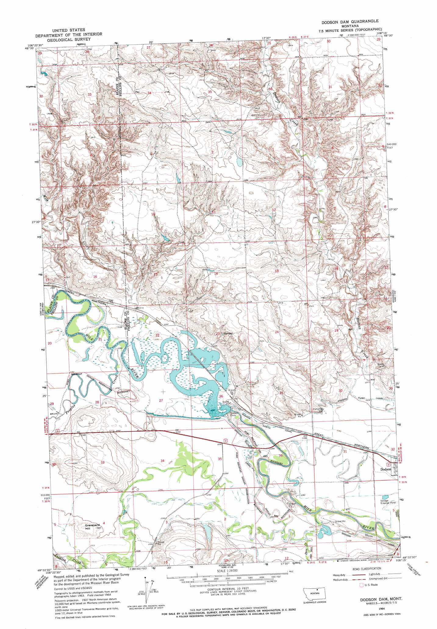
Dodson Dam Topo Map Montana
To zoom in, hover over the map of Dodson Dam
USGS Topo Quad 48108d3 - 1:24,000 scale
| Topo Map Name: | Dodson Dam |
| USGS Topo Quad ID: | 48108d3 |
| Print Size: | ca. 21 1/4" wide x 27" high |
| Southeast Coordinates: | 48.375° N latitude / 108.25° W longitude |
| Map Center Coordinates: | 48.4375° N latitude / 108.3125° W longitude |
| U.S. State: | MT |
| Filename: | o48108d3.jpg |
| Download Map JPG Image: | Dodson Dam topo map 1:24,000 scale |
| Map Type: | Topographic |
| Topo Series: | 7.5´ |
| Map Scale: | 1:24,000 |
| Source of Map Images: | United States Geological Survey (USGS) |
| Alternate Map Versions: |
Dodson Dam MT 1964, updated 1968 Download PDF Buy paper map Dodson Dam MT 2011 Download PDF Buy paper map Dodson Dam MT 2014 Download PDF Buy paper map |
1:24,000 Topo Quads surrounding Dodson Dam
Hornbeck Lake |
Down Reservoir Nw |
Down Reservoir Ne |
Emerick Bench |
Hubert Hill |
Wayne Creek Se |
Down Reservoir Sw |
Down Reservoir |
Hubert Hill Sw |
Hubert Hill Se |
Savoy |
Coburg |
Dodson Dam |
Dodson |
Dodson Ne |
Bigby Lake |
Weigand Reservoir |
Coburg Se |
Cow Creek |
Wagner |
Lodge Pole Ne |
Big Flat West |
Big Flat East |
Wild Horse Reservoir |
West Alkali Reservoir |
> Back to 48108a1 at 1:100,000 scale
> Back to 48108a1 at 1:250,000 scale
> Back to U.S. Topo Maps home
Dodson Dam topo map: Gazetteer
Dodson Dam: Dams
Dodson Dam elevation 698m 2290′Dodson Dam elevation 700m 2296′
M Newby Dam elevation 698m 2290′
Strike Reservoir Dam elevation 698m 2290′
Dodson Dam: Parks
Milk River - Dodson Dam Unit Wildlife Management Area elevation 727m 2385′Dodson Dam: Streams
Deer Creek elevation 696m 2283′Milk Creek elevation 698m 2290′
Peoples Creek elevation 699m 2293′
Dodson Dam: Wells
30N26E03CCBC01 Well elevation 704m 2309′30N26E03DBA_01 Well elevation 704m 2309′
31N26E32ADD_01 Well elevation 715m 2345′
31N26E33CCB_01 Well elevation 704m 2309′
31N26E33DBCA01 Well elevation 728m 2388′
Dodson Dam digital topo map on disk
Buy this Dodson Dam topo map showing relief, roads, GPS coordinates and other geographical features, as a high-resolution digital map file on DVD: