Fort Belknap Agency Topo Map Montana
To zoom in, hover over the map of Fort Belknap Agency
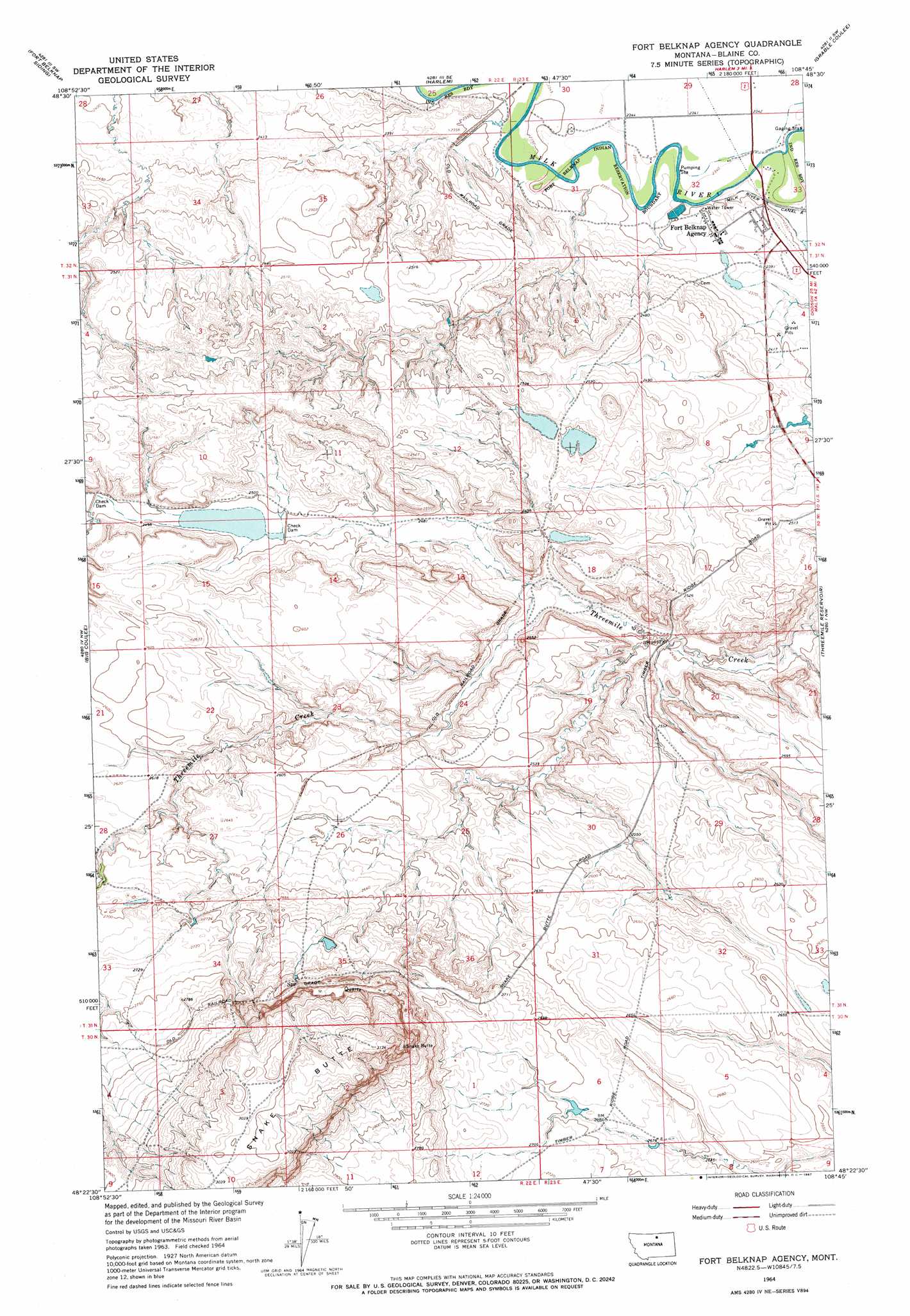
USGS Topo Quad 48108d7 - 1:24,000 scale
| Topo Map Name: | Fort Belknap Agency |
| USGS Topo Quad ID: | 48108d7 |
| Print Size: | ca. 21 1/4" wide x 27" high |
| Southeast Coordinates: | 48.375° N latitude / 108.75° W longitude |
| Map Center Coordinates: | 48.4375° N latitude / 108.8125° W longitude |
| U.S. State: | MT |
| Filename: | o48108d7.jpg |
| Download Map JPG Image: | Fort Belknap Agency topo map 1:24,000 scale |
| Map Type: | Topographic |
| Topo Series: | 7.5´ |
| Map Scale: | 1:24,000 |
| Source of Map Images: | United States Geological Survey (USGS) |
| Alternate Map Versions: |
Fort Belknap Agency MT 1964, updated 1967 Download PDF Buy paper map Fort Belknap Agency MT 2011 Download PDF Buy paper map Fort Belknap Agency MT 2014 Download PDF Buy paper map |
1:24,000 Topo Quads surrounding Fort Belknap Agency
Tule Lake |
Harlem Nw |
East Butte |
Wayne Creek Nw |
Hornbeck Lake |
Zurich |
Fort Belknap Siding |
Harlem |
Grable Coulee |
Wayne Creek Se |
Cleveland Ne |
Big Coulee |
Fort Belknap Agency |
Threemile Reservoir |
Savoy |
Miles Butte |
Newhouse Reservoir |
Fort Belknap Agency Se |
Wild Horse Butte |
Bigby Lake |
Suction Butte |
Putnam Lake |
Lake Seventeen Ne |
Lodge Pole Nw |
Lodge Pole Ne |
> Back to 48108a1 at 1:100,000 scale
> Back to 48108a1 at 1:250,000 scale
> Back to U.S. Topo Maps home
Fort Belknap Agency topo map: Gazetteer
Fort Belknap Agency: Airports
Fort Belknap Agency Airport elevation 723m 2372′Fort Belknap Agency: Dams
Fort Belknap Sewage Lagoon Dam elevation 727m 2385′Indian Bathtub Dam elevation 826m 2709′
Snake Butte Reservoir Dam elevation 762m 2500′
Fort Belknap Agency: Parks
Fort Belknap Reservation Historical Marker elevation 723m 2372′Vision Quest Historical Marker elevation 723m 2372′
Fort Belknap Agency: Populated Places
Fort Belknap elevation 723m 2372′Fort Belknap Agency elevation 724m 2375′
Newtown elevation 723m 2372′
Fort Belknap Agency: Wells
31N23E04BBDD01 Well elevation 724m 2375′31N23E05ADDC01 Well elevation 728m 2388′
31N23E05DDDC01 Well elevation 742m 2434′
31N23E09CACA01 Well elevation 750m 2460′
31N23E18ACDC01 Well elevation 781m 2562′
Fort Belknap Agency digital topo map on disk
Buy this Fort Belknap Agency topo map showing relief, roads, GPS coordinates and other geographical features, as a high-resolution digital map file on DVD: