Laredo Topo Map Montana
To zoom in, hover over the map of Laredo
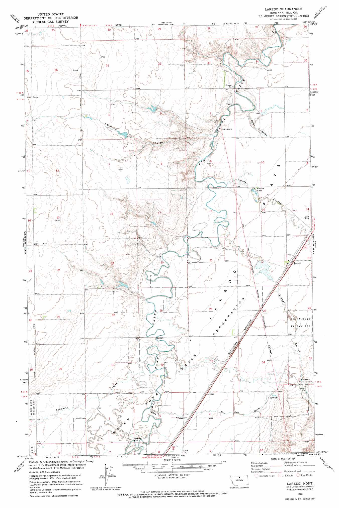
USGS Topo Quad 48109d8 - 1:24,000 scale
| Topo Map Name: | Laredo |
| USGS Topo Quad ID: | 48109d8 |
| Print Size: | ca. 21 1/4" wide x 27" high |
| Southeast Coordinates: | 48.375° N latitude / 109.875° W longitude |
| Map Center Coordinates: | 48.4375° N latitude / 109.9375° W longitude |
| U.S. State: | MT |
| Filename: | o48109d8.jpg |
| Download Map JPG Image: | Laredo topo map 1:24,000 scale |
| Map Type: | Topographic |
| Topo Series: | 7.5´ |
| Map Scale: | 1:24,000 |
| Source of Map Images: | United States Geological Survey (USGS) |
| Alternate Map Versions: |
Laredo MT 1970, updated 1984 Download PDF Buy paper map Laredo MT 2011 Download PDF Buy paper map Laredo MT 2014 Download PDF Buy paper map |
1:24,000 Topo Quads surrounding Laredo
Dry Lake |
Saddle Butte |
Kiehns Coulee |
Quigley Coulee |
Havre Nw |
Sage Lake |
Kremlin |
Fresno Dam |
Herron Park |
Havre |
Box Elder Nw |
Bailey Reservoir |
Laredo |
Laredo Ne |
Cement Hill |
Lonesome Lake |
Box Elder |
Cowan Reservoir |
Rocky Boy |
Bearpaw Lake |
Ihmsen Well |
Big Sandy |
Table Butte |
Centennial Mountain |
Bowery Peak |
> Back to 48109a1 at 1:100,000 scale
> Back to 48108a1 at 1:250,000 scale
> Back to U.S. Topo Maps home
Laredo topo map: Gazetteer
Laredo: Dams
Big Gravel Dam Number 1 elevation 799m 2621′Big Jugs Dam elevation 804m 2637′
Boyer Dam elevation 790m 2591′
Daniel Number 1 Dam elevation 821m 2693′
Daniel Number 2 Dam elevation 815m 2673′
Daniel Number 3 Dam elevation 788m 2585′
Wilfred Tow Dam elevation 799m 2621′
Laredo: Flats
Laredo Flats elevation 799m 2621′Laredo: Lakes
Prairie Lake elevation 790m 2591′Laredo: Populated Places
Laredo elevation 806m 2644′Laredo: Post Offices
Laredo Post Office (historical) elevation 806m 2644′Laredo: Valleys
Antelope Coulee elevation 779m 2555′Conner Coulee elevation 781m 2562′
Dry Fork Coulee elevation 799m 2621′
Gravel Coulee elevation 784m 2572′
Middle Coulee elevation 791m 2595′
Schwartz Coulee elevation 793m 2601′
Spring Coulee elevation 783m 2568′
Laredo: Wells
31N14E02BA__01 Well elevation 790m 2591′31N14E03CDDC01 Well elevation 788m 2585′
31N14E15BA__01 Well elevation 790m 2591′
31N14E15DD__01 Well elevation 800m 2624′
31N14E23BC__01 Well elevation 805m 2641′
31N14E23BC__02 Well elevation 805m 2641′
31N14E23CC__01 Well elevation 803m 2634′
31N14E32DC__01 Well elevation 795m 2608′
31N14E33BC__01 Well elevation 799m 2621′
31N14E34AA__01 Well elevation 813m 2667′
32N14E33DD__01 Well elevation 790m 2591′
Laredo digital topo map on disk
Buy this Laredo topo map showing relief, roads, GPS coordinates and other geographical features, as a high-resolution digital map file on DVD: