Havre Topo Map Montana
To zoom in, hover over the map of Havre
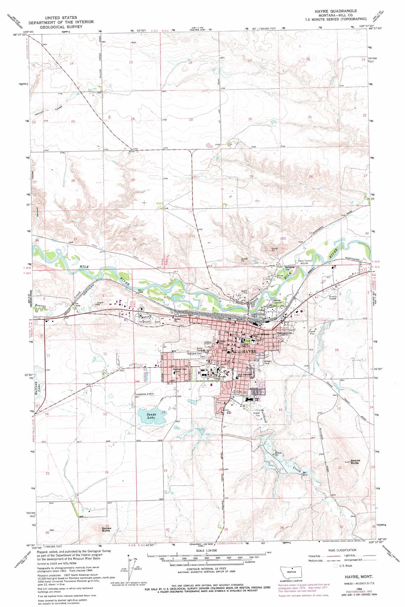
USGS Topo Quad 48109e6 - 1:24,000 scale
| Topo Map Name: | Havre |
| USGS Topo Quad ID: | 48109e6 |
| Print Size: | ca. 21 1/4" wide x 27" high |
| Southeast Coordinates: | 48.5° N latitude / 109.625° W longitude |
| Map Center Coordinates: | 48.5625° N latitude / 109.6875° W longitude |
| U.S. State: | MT |
| Filename: | o48109e6.jpg |
| Download Map JPG Image: | Havre topo map 1:24,000 scale |
| Map Type: | Topographic |
| Topo Series: | 7.5´ |
| Map Scale: | 1:24,000 |
| Source of Map Images: | United States Geological Survey (USGS) |
| Alternate Map Versions: |
Havre MT 1964, updated 1967 Download PDF Buy paper map Havre MT 1964, updated 1978 Download PDF Buy paper map Havre MT 2011 Download PDF Buy paper map Havre MT 2014 Download PDF Buy paper map |
1:24,000 Topo Quads surrounding Havre
Cottonwood |
Hilldale Colony |
Lake Thibadeau Sw |
Lake Thibadeau |
Mclaren Reservoir |
Kiehns Coulee |
Quigley Coulee |
Havre Nw |
Havre Ne |
Reservoir Coulee |
Fresno Dam |
Herron Park |
Havre |
Havre Se |
Lohman |
Laredo |
Laredo Ne |
Cement Hill |
Shambo Ne |
Lloyd Nw |
Cowan Reservoir |
Rocky Boy |
Bearpaw Lake |
Shambo Se |
Barber Butte |
> Back to 48109e1 at 1:100,000 scale
> Back to 48108a1 at 1:250,000 scale
> Back to U.S. Topo Maps home
Havre topo map: Gazetteer
Havre: Airports
Sands Ranch Airport elevation 793m 2601′Havre: Dams
Bullhook Dam elevation 790m 2591′Bullhook Lower Diversion Dam elevation 770m 2526′
Epiphany Dam elevation 861m 2824′
Sands Lake East Dike elevation 801m 2627′
Sands Lake North Dam elevation 801m 2627′
Scott Coulee Dam elevation 802m 2631′
Havre: Parks
American Legion Park elevation 794m 2604′Carpenter Park elevation 757m 2483′
Deaconess Park elevation 771m 2529′
Eagles Park elevation 757m 2483′
Elks Park elevation 767m 2516′
First Bank Park elevation 783m 2568′
Havre Historical Marker elevation 775m 2542′
Heritage Park elevation 770m 2526′
Hidden Valley Park elevation 784m 2572′
Keystone Park elevation 757m 2483′
Kuhr Memorial Park elevation 778m 2552′
Lions Park elevation 757m 2483′
Optimist Park elevation 816m 2677′
Patterson Park elevation 794m 2604′
Pepin Park elevation 760m 2493′
Rotary Park elevation 775m 2542′
Sixth Avenue Park elevation 764m 2506′
Slowpitch Complex elevation 785m 2575′
South Curve Park elevation 766m 2513′
Sunrise Edition Park elevation 777m 2549′
Tourist Park elevation 757m 2483′
Wahkpa Chu'gn Meat Market Historical Marker elevation 785m 2575′
Havre: Populated Places
A and B Trailer Court Number One elevation 759m 2490′A and B Trailer Court Number Two elevation 771m 2529′
Bitterroot Trailer Court elevation 800m 2624′
Clear Creek Terrace Trailer Court elevation 766m 2513′
Fairview Terrace Trailer Court elevation 777m 2549′
Frigon Trailer Court elevation 763m 2503′
Hacienda Trailer Court elevation 760m 2493′
Havre elevation 771m 2529′
Heads Trailer Court elevation 761m 2496′
Hillside Trailer Court elevation 760m 2493′
Hollingshead Trailer Court elevation 755m 2477′
Lakeside Plaza Mobile Home Park elevation 799m 2621′
Pats Trailer Park elevation 774m 2539′
Poplars Trailer Court elevation 799m 2621′
Riverside Trailer Court elevation 757m 2483′
Saddle Butte elevation 828m 2716′
Schubring Trailer Court elevation 774m 2539′
Shennum Trailer Court elevation 754m 2473′
Simko Trailer Court elevation 754m 2473′
Thiels West Trailer Court elevation 790m 2591′
West Havre elevation 796m 2611′
Havre: Post Offices
Havre Post Office elevation 760m 2493′Havre: Reservoirs
Sands Lake elevation 801m 2627′Havre: Streams
Beaver Creek elevation 755m 2477′Bullhook Creek elevation 764m 2506′
Havre: Summits
Indian Woman Butte elevation 926m 3038′Saddle Butte elevation 946m 3103′
Havre: Wells
32N15E25ACDD01 Well elevation 840m 2755′32N16E03CCCC01 Well elevation 764m 2506′
32N16E04DDBA01 Well elevation 769m 2522′
32N16E17ADDB01 Well elevation 770m 2526′
Havre digital topo map on disk
Buy this Havre topo map showing relief, roads, GPS coordinates and other geographical features, as a high-resolution digital map file on DVD: