Rudyard Topo Map Montana
To zoom in, hover over the map of Rudyard
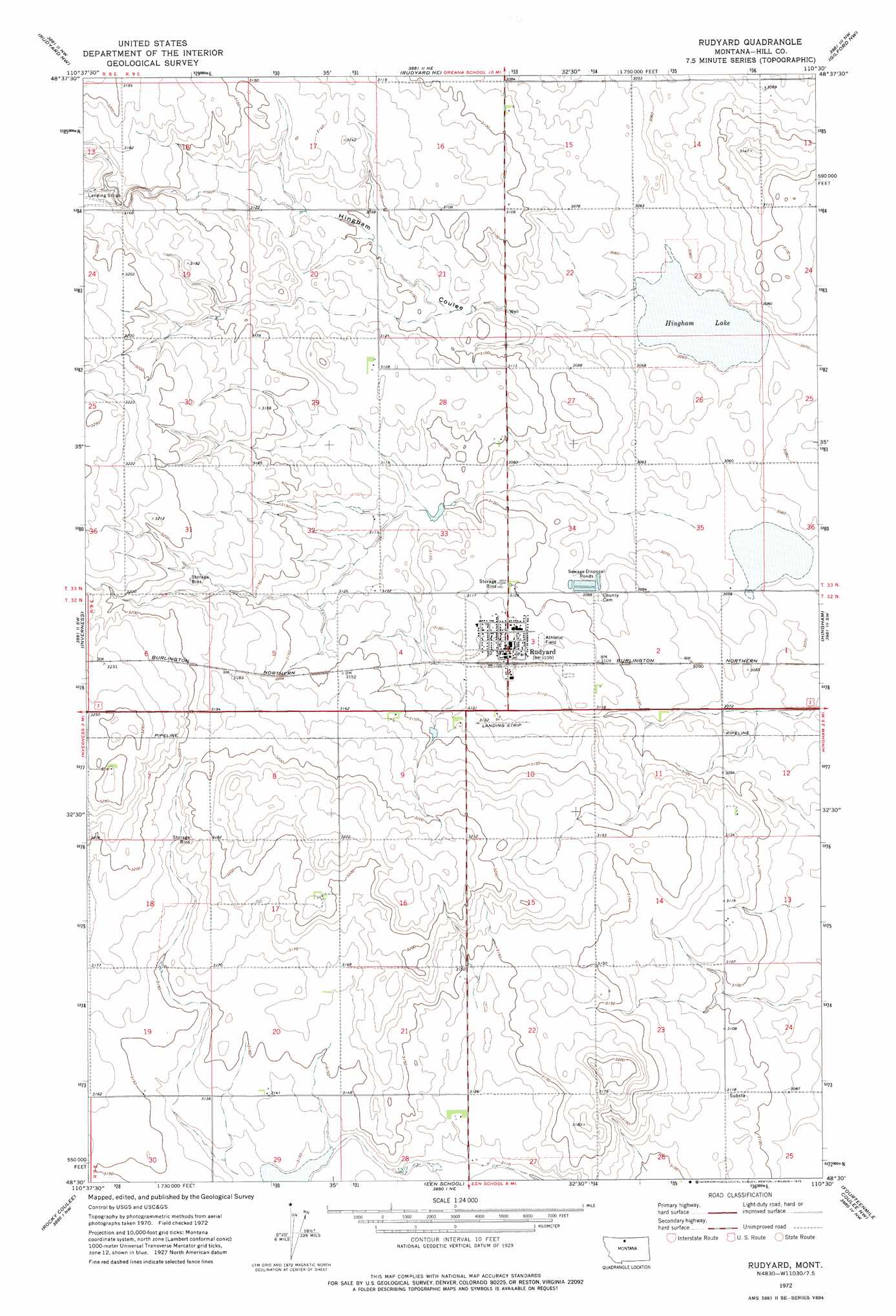
USGS Topo Quad 48110e5 - 1:24,000 scale
| Topo Map Name: | Rudyard |
| USGS Topo Quad ID: | 48110e5 |
| Print Size: | ca. 21 1/4" wide x 27" high |
| Southeast Coordinates: | 48.5° N latitude / 110.5° W longitude |
| Map Center Coordinates: | 48.5625° N latitude / 110.5625° W longitude |
| U.S. State: | MT |
| Filename: | o48110e5.jpg |
| Download Map JPG Image: | Rudyard topo map 1:24,000 scale |
| Map Type: | Topographic |
| Topo Series: | 7.5´ |
| Map Scale: | 1:24,000 |
| Source of Map Images: | United States Geological Survey (USGS) |
| Alternate Map Versions: |
Rudyard MT 1972, updated 1975 Download PDF Buy paper map Rudyard MT 2011 Download PDF Buy paper map Rudyard MT 2014 Download PDF Buy paper map |
1:24,000 Topo Quads surrounding Rudyard
Bobcat Coulee Se |
Goldstone Sw |
Mckinnsey Reservoir West |
Mckinnsey Reservoir East |
Ninemile Coulee West |
Chester Ne |
Rudyard Nw |
Rudyaro Ne |
Gildford Nw |
Gildford Ne |
Joplin |
Inverness |
Rudyard |
Hingham |
Gildford |
Poverty Coulee Ne |
Rocky Coulee |
Een School |
Fourteenmile Coulee Nw |
Fourteenmile Coulee Ne |
Poverty Coulee Se |
Rocky Coulee Sw |
Rocky Coulee Se |
Fourteenmile Coulee Sw |
Fourteenmile Coulee Se |
> Back to 48110e1 at 1:100,000 scale
> Back to 48110a1 at 1:250,000 scale
> Back to U.S. Topo Maps home
Rudyard topo map: Gazetteer
Rudyard: Dams
Bye Gone Dam elevation 943m 3093′Rudyard: Lakes
Hingham Lake elevation 932m 3057′Rudyard: Populated Places
Rudyard elevation 949m 3113′Rudyard: Post Offices
Rudyard Post Office elevation 949m 3113′Rudyard: Valleys
Hingham Coulee elevation 933m 3061′Rudyard: Wells
32N09E03CAAB01 Well elevation 949m 3113′32N09E03CBA_01 Well elevation 952m 3123′
32N09E09AADB01 Well elevation 958m 3143′
33N09E28DDA_01 Well elevation 946m 3103′
Rudyard digital topo map on disk
Buy this Rudyard topo map showing relief, roads, GPS coordinates and other geographical features, as a high-resolution digital map file on DVD: