Uphill Creek Topo Map Montana
To zoom in, hover over the map of Uphill Creek
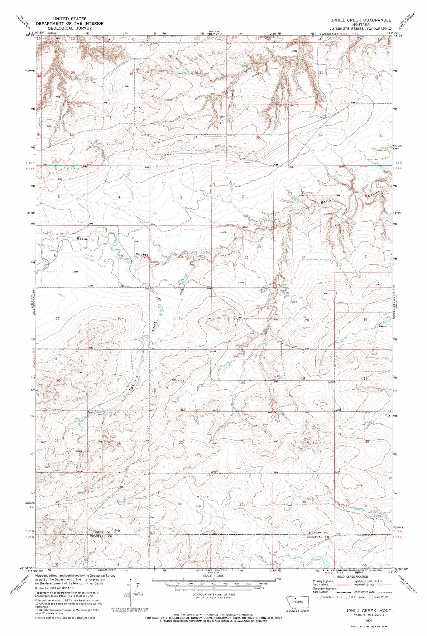
USGS Topo Quad 48111b1 - 1:24,000 scale
| Topo Map Name: | Uphill Creek |
| USGS Topo Quad ID: | 48111b1 |
| Print Size: | ca. 21 1/4" wide x 27" high |
| Southeast Coordinates: | 48.125° N latitude / 111° W longitude |
| Map Center Coordinates: | 48.1875° N latitude / 111.0625° W longitude |
| U.S. State: | MT |
| Filename: | o48111b1.jpg |
| Download Map JPG Image: | Uphill Creek topo map 1:24,000 scale |
| Map Type: | Topographic |
| Topo Series: | 7.5´ |
| Map Scale: | 1:24,000 |
| Source of Map Images: | United States Geological Survey (USGS) |
| Alternate Map Versions: |
Uphill Creek MT 1970, updated 1973 Download PDF Buy paper map Uphill Creek MT 2011 Download PDF Buy paper map Uphill Creek MT 2014 Download PDF Buy paper map |
1:24,000 Topo Quads surrounding Uphill Creek
Galata |
Lothair |
Sagebrush Coulee |
Poverty Coulee |
Poverty Coulee Ne |
Pondera School |
Lothair Sw |
Tiber Dam |
Circle Bridge |
Poverty Coulee Se |
Knees Ne |
Carlson Coulee |
Uphill Creek |
Goose Bill Butte Nw |
Penzer School |
Knees |
Mcbridy Spring |
Russell Chapel |
Dorner School |
Goose Bill Butte |
Shannon Bridge |
Dent Bridge |
Dent Bridge Ne |
Apple School |
Carter Ne |
> Back to 48111a1 at 1:100,000 scale
> Back to 48110a1 at 1:250,000 scale
> Back to U.S. Topo Maps home
Uphill Creek topo map: Gazetteer
Uphill Creek: Dams
Roamin' Reservoir Dam elevation 953m 3126′State Number 2 Dam elevation 925m 3034′
State Number 3 Dam elevation 923m 3028′
Uphill Creek: Populated Places
Riverview Colony elevation 974m 3195′Uphill Creek: Post Offices
Hervin Post Office (historical) elevation 954m 3129′Rosebranch Post Office (historical) elevation 949m 3113′
Uphill Creek: Streams
Uphill Creek elevation 916m 3005′Uphill Creek: Valleys
Alkali Springs Coulee elevation 931m 3054′Uphill Creek digital topo map on disk
Buy this Uphill Creek topo map showing relief, roads, GPS coordinates and other geographical features, as a high-resolution digital map file on DVD: