Mount Lebanon Topo Map Montana
To zoom in, hover over the map of Mount Lebanon
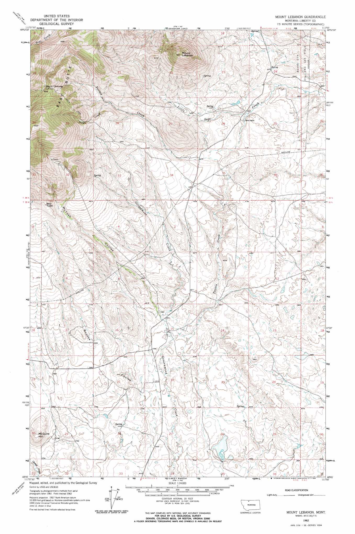
USGS Topo Quad 48111g1 - 1:24,000 scale
| Topo Map Name: | Mount Lebanon |
| USGS Topo Quad ID: | 48111g1 |
| Print Size: | ca. 21 1/4" wide x 27" high |
| Southeast Coordinates: | 48.75° N latitude / 111° W longitude |
| Map Center Coordinates: | 48.8125° N latitude / 111.0625° W longitude |
| U.S. State: | MT |
| Filename: | o48111g1.jpg |
| Download Map JPG Image: | Mount Lebanon topo map 1:24,000 scale |
| Map Type: | Topographic |
| Topo Series: | 7.5´ |
| Map Scale: | 1:24,000 |
| Source of Map Images: | United States Geological Survey (USGS) |
| Alternate Map Versions: |
Mount Lebanon MT 1962, updated 1964 Download PDF Buy paper map Mount Lebanon MT 2011 Download PDF Buy paper map Mount Lebanon MT 2014 Download PDF Buy paper map |
1:24,000 Topo Quads surrounding Mount Lebanon
Whitlash |
Hawley Hill |
Bingham Lake |
Laird School |
Bobcat Coulee Ne |
Grassy Butte |
Haystack Butte |
Mount Lebanon |
Vaver Reservoir |
Bobcat Coulee Se |
Berkholder Reservoir |
Blair Ranch |
Lakey Ranch |
Chester Nw |
Chester Ne |
Mccarters Lake Se |
North Lothair School |
Tiber |
Chester |
Joplin |
> Back to 48111e1 at 1:100,000 scale
> Back to 48110a1 at 1:250,000 scale
> Back to U.S. Topo Maps home
Mount Lebanon topo map: Gazetteer
Mount Lebanon: Dams
Meissner Dam elevation 1098m 3602′Mount Lebanon: Mines
Tiber Quarry elevation 1593m 5226′Tootsie Creek Number 1 Mine elevation 1637m 5370′
Tootsie Creek Number 2 Mine elevation 1721m 5646′
Mount Lebanon: Pillars
Bear Tooth elevation 1460m 4790′Mount Lebanon: Streams
Iron Creek elevation 1396m 4580′Tootsie Creek elevation 1157m 3795′
Mount Lebanon: Summits
Devils Chimney elevation 1681m 5515′East Butte elevation 1676m 5498′
McGuire Hill elevation 1221m 4005′
Mount Lebanon elevation 1745m 5725′
Mount Lebanon: Valleys
McTosh Coulee elevation 1167m 3828′Snoose Coulee elevation 1092m 3582′
Mount Lebanon: Wells
35N05E15CAAC01 Well elevation 1157m 3795′35N05E20BACC01 Well elevation 1191m 3907′
Mount Lebanon digital topo map on disk
Buy this Mount Lebanon topo map showing relief, roads, GPS coordinates and other geographical features, as a high-resolution digital map file on DVD: