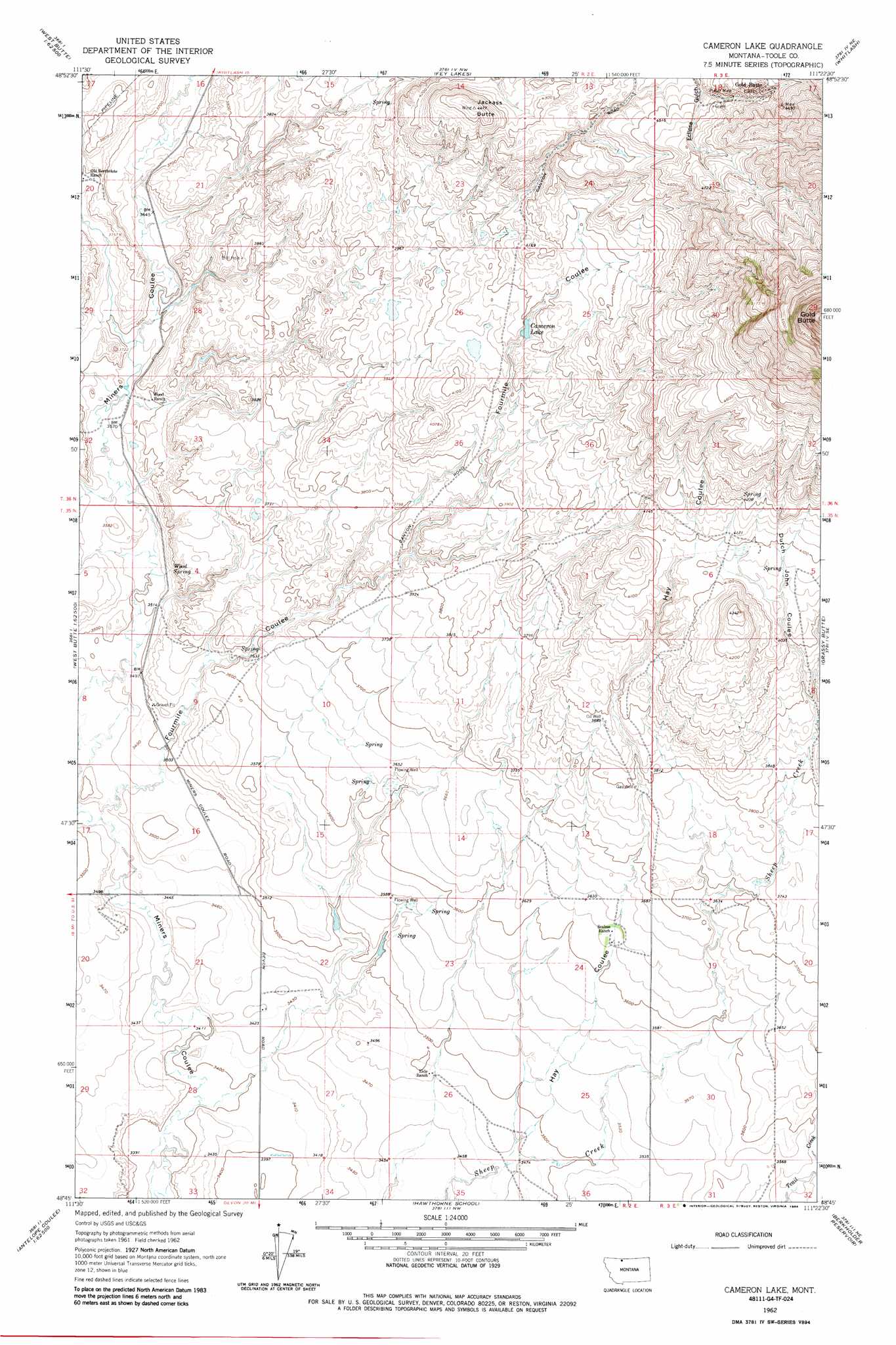
Cameron Lake Topo Map Montana
To zoom in, hover over the map of Cameron Lake
USGS Topo Quad 48111g4 - 1:24,000 scale
| Topo Map Name: | Cameron Lake |
| USGS Topo Quad ID: | 48111g4 |
| Print Size: | ca. 21 1/4" wide x 27" high |
| Southeast Coordinates: | 48.75° N latitude / 111.375° W longitude |
| Map Center Coordinates: | 48.8125° N latitude / 111.4375° W longitude |
| U.S. State: | MT |
| Filename: | o48111g4.jpg |
| Download Map JPG Image: | Cameron Lake topo map 1:24,000 scale |
| Map Type: | Topographic |
| Topo Series: | 7.5´ |
| Map Scale: | 1:24,000 |
| Source of Map Images: | United States Geological Survey (USGS) |
| Alternate Map Versions: |
Cameron Lake MT 1962, updated 1964 Download PDF Buy paper map Cameron Lake MT 1962, updated 1984 Download PDF Buy paper map Cameron Lake MT 2011 Download PDF Buy paper map Cameron Lake MT 2014 Download PDF Buy paper map |
1:24,000 Topo Quads surrounding Cameron Lake
Beaupre Coulee |
West Butte |
Fey Lakes |
Whitlash |
Hawley Hill |
Fivemile Coulee West |
Fivemile Coulee East |
Cameron Lake |
Grassy Butte |
Haystack Butte |
Antelope Coulee Nw |
Johannson Coulee |
Hawthorne School |
Berkholder Reservoir |
Blair Ranch |
Antelope Coulee Sw |
Antelope Coulee Se |
Mccarters Lake |
Mccarters Lake Se |
North Lothair School |
> Back to 48111e1 at 1:100,000 scale
> Back to 48110a1 at 1:250,000 scale
> Back to U.S. Topo Maps home
Cameron Lake topo map: Gazetteer
Cameron Lake: Dams
Cameron Dam elevation 1248m 4094′MacHale Dam elevation 1169m 3835′
Wood Dam elevation 1089m 3572′
Cameron Lake: Lakes
Cameron Lake elevation 1236m 4055′Cameron Lake: Populated Places
Gold Butte elevation 1408m 4619′Cameron Lake: Post Offices
Goldbutte Post Office (historical) elevation 1404m 4606′Cameron Lake: Ranges
Sweet Grass Hills elevation 1923m 6309′Cameron Lake: Reservoirs
Cameron Reservoir elevation 1248m 4094′MacHale Reservoir elevation 1169m 3835′
Parsell Lake elevation 1231m 4038′
Wood Reservoir elevation 1089m 3572′
Cameron Lake: Springs
35N02E04BDCC01 Spring elevation 1083m 3553′35N03E05BCCC01 Spring elevation 1242m 4074′
36N03E18DDAA01 Spring elevation 1411m 4629′
36N03E31DCDA01 Spring elevation 1286m 4219′
Wood Spring elevation 1086m 3562′
Cameron Lake: Streams
Canon Creek elevation 1088m 3569′Cameron Lake: Summits
Gold Butte elevation 1977m 6486′Jackass Butte elevation 1345m 4412′
Cameron Lake: Valleys
Alkali Coulee elevation 1037m 3402′Dutch John Coulee elevation 1185m 3887′
Fourmile Coulee elevation 1054m 3458′
Hay Coulee elevation 1058m 3471′
Lemky Coulee elevation 1104m 3622′
Snow Coulee elevation 1061m 3480′
Cameron Lake: Wells
35N02E10DD__01 Well elevation 1117m 3664′35N02E22CCCA01 Well elevation 1050m 3444′
35N02E23BBBB01 Well elevation 1085m 3559′
35N02E27AABD01 Well elevation 1066m 3497′
35N03E05BCCC01 Well elevation 1244m 4081′
Cameron Lake digital topo map on disk
Buy this Cameron Lake topo map showing relief, roads, GPS coordinates and other geographical features, as a high-resolution digital map file on DVD: