Sunburst Topo Map Montana
To zoom in, hover over the map of Sunburst
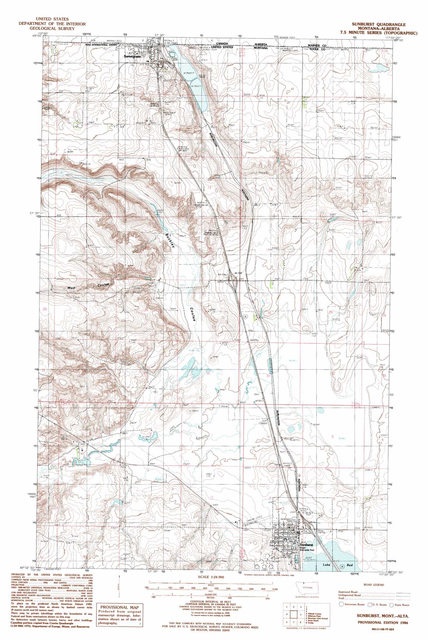
USGS Topo Quad 48111h8 - 1:24,000 scale
| Topo Map Name: | Sunburst |
| USGS Topo Quad ID: | 48111h8 |
| Print Size: | ca. 21 1/4" wide x 27" high |
| Southeast Coordinates: | 48.875° N latitude / 111.875° W longitude |
| Map Center Coordinates: | 48.9375° N latitude / 111.9375° W longitude |
| U.S. State: | MT |
| Filename: | o48111h8.jpg |
| Download Map JPG Image: | Sunburst topo map 1:24,000 scale |
| Map Type: | Topographic |
| Topo Series: | 7.5´ |
| Map Scale: | 1:24,000 |
| Source of Map Images: | United States Geological Survey (USGS) |
| Alternate Map Versions: |
Sunburst MT 1986, updated 1986 Download PDF Buy paper map Sunburst MT 2011 Download PDF Buy paper map Sunburst MT 2014 Download PDF Buy paper map |
1:24,000 Topo Quads surrounding Sunburst
Fitzpatrick Lake |
Hillside Colony |
Sunburst |
Willshaw Flats |
Beaupre Coulee |
Glacier Colony |
Mountain View School |
Kevin North |
Ferdig |
Fivemile Coulee West |
Ethridge Nw |
Aloe |
Kevin South |
Oilmont |
Antelope Coulee Nw |
> Back to 48111e1 at 1:100,000 scale
> Back to 48110a1 at 1:250,000 scale
> Back to U.S. Topo Maps home
Sunburst topo map: Gazetteer
Sunburst: Airports
Ross International Airport elevation 1081m 3546′Sunburst Airport elevation 1031m 3382′
Sunburst: Crossings
Interchange 389 elevation 1023m 3356′Interchange 394 elevation 1029m 3375′
Interchange 397 elevation 1067m 3500′
Sunburst: Dams
Hunky Dorie Dam elevation 1066m 3497′Sunburst: Parks
Engel Memorial Park elevation 1021m 3349′Sunburst: Populated Places
Sunburst elevation 1026m 3366′Sweet Grass elevation 1066m 3497′
Sunburst: Post Offices
Sunburst Post Office elevation 1023m 3356′Sweetgrass Post Office elevation 1066m 3497′
Sunburst: Summits
Jerusalem Rocks elevation 1090m 3576′Sunburst: Valleys
Buckley Coulee elevation 1020m 3346′Sunburst Coulee elevation 1019m 3343′
Wolf Coulee elevation 1066m 3497′
Sunburst: Wells
36N02W08CDC_01 Well elevation 1019m 3343′36N03W03CB__01 Well elevation 1052m 3451′
37N03W02AB__01 Well elevation 1074m 3523′
37N03W02AC__01 Well elevation 1063m 3487′
37N03W02BA__01 Well elevation 1081m 3546′
37N03W02BD__01 Well elevation 1077m 3533′
37N03W02BD__02 Well elevation 1077m 3533′
37N03W02CA__01 Well elevation 1080m 3543′
37N03W03CD__01 Well elevation 1085m 3559′
37N03W04AD__01 Well elevation 1068m 3503′
37N03W04DD__01 Well elevation 1076m 3530′
37N03W10BD__01 Well elevation 1094m 3589′
37N03W11CB__01 Well elevation 1107m 3631′
37N03W12CA__01 Well elevation 1059m 3474′
37N03W14AA__01 Well elevation 1114m 3654′
37N03W22AC__01 Well elevation 1140m 3740′
37N03W22DB__01 Well elevation 1116m 3661′
37N03W23AA__01 Well elevation 1033m 3389′
Sunburst digital topo map on disk
Buy this Sunburst topo map showing relief, roads, GPS coordinates and other geographical features, as a high-resolution digital map file on DVD: