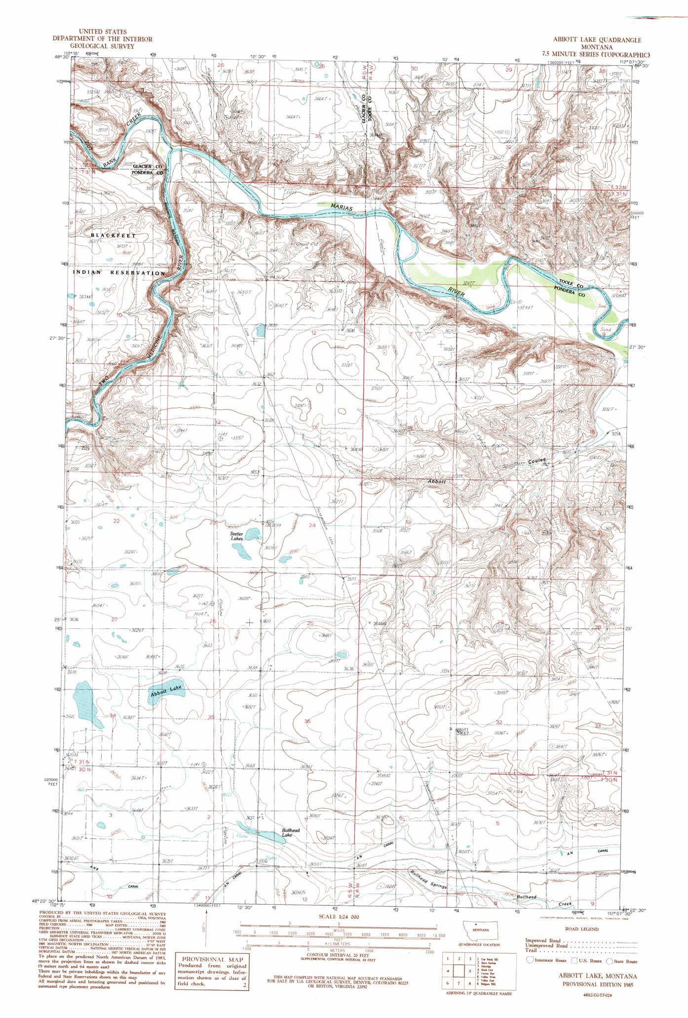
Abbott Lake Topo Map Montana
To zoom in, hover over the map of Abbott Lake
USGS Topo Quad 48112d2 - 1:24,000 scale
| Topo Map Name: | Abbott Lake |
| USGS Topo Quad ID: | 48112d2 |
| Print Size: | ca. 21 1/4" wide x 27" high |
| Southeast Coordinates: | 48.375° N latitude / 112.125° W longitude |
| Map Center Coordinates: | 48.4375° N latitude / 112.1875° W longitude |
| U.S. State: | MT |
| Filename: | o48112d2.jpg |
| Download Map JPG Image: | Abbott Lake topo map 1:24,000 scale |
| Map Type: | Topographic |
| Topo Series: | 7.5´ |
| Map Scale: | 1:24,000 |
| Source of Map Images: | United States Geological Survey (USGS) |
| Alternate Map Versions: |
Abbott Lake MT 1985, updated 1986 Download PDF Buy paper map Abbott Lake MT 2011 Download PDF Buy paper map Abbott Lake MT 2014 Download PDF Buy paper map |
1:24,000 Topo Quads surrounding Abbott Lake
Gunsight |
Cut Bank |
Ethridge Nw |
Aloe |
Kevin South |
Squaw Buttes |
Cut Bank Se |
Boru Spring |
Ethridge |
Virden |
Flag Butte |
Rock City |
Abbott Lake |
Cactus Flat |
Ledger Nw |
Kuka Crossing |
Valier West |
Valier East |
Belgian Hill |
Pioneer School |
Dupuyer East |
Lone Man Coulee West |
Lone Man Coulee East |
Sam George Hill |
Conrad |
> Back to 48112a1 at 1:100,000 scale
> Back to 48112a1 at 1:250,000 scale
> Back to U.S. Topo Maps home
Abbott Lake topo map: Gazetteer
Abbott Lake: Bridges
Sullivan Bridge elevation 1005m 3297′Abbott Lake: Canals
AN Canal elevation 1111m 3645′Bullhead Drop elevation 1127m 3697′
Abbott Lake: Cliffs
Cut Bank elevation 1041m 3415′Abbott Lake: Lakes
Abbott Lake elevation 1103m 3618′Stetler Lakes elevation 1098m 3602′
Abbott Lake: Populated Places
Abbott Lake (historical) elevation 1109m 3638′Abbott Lake: Ridges
Abbott Ridge elevation 1169m 3835′Abbott Lake: Springs
Bullhead Springs elevation 1097m 3599′Abbott Lake: Streams
Cut Bank Creek elevation 1004m 3293′Two Medicine River elevation 1004m 3293′
Abbott Lake: Valleys
Abbott Coulee elevation 986m 3234′Abbott Lake: Wells
30N04W06CDBB01 Well elevation 1103m 3618′Abbott Lake digital topo map on disk
Buy this Abbott Lake topo map showing relief, roads, GPS coordinates and other geographical features, as a high-resolution digital map file on DVD: