Hillside Colony Topo Map Montana
To zoom in, hover over the map of Hillside Colony
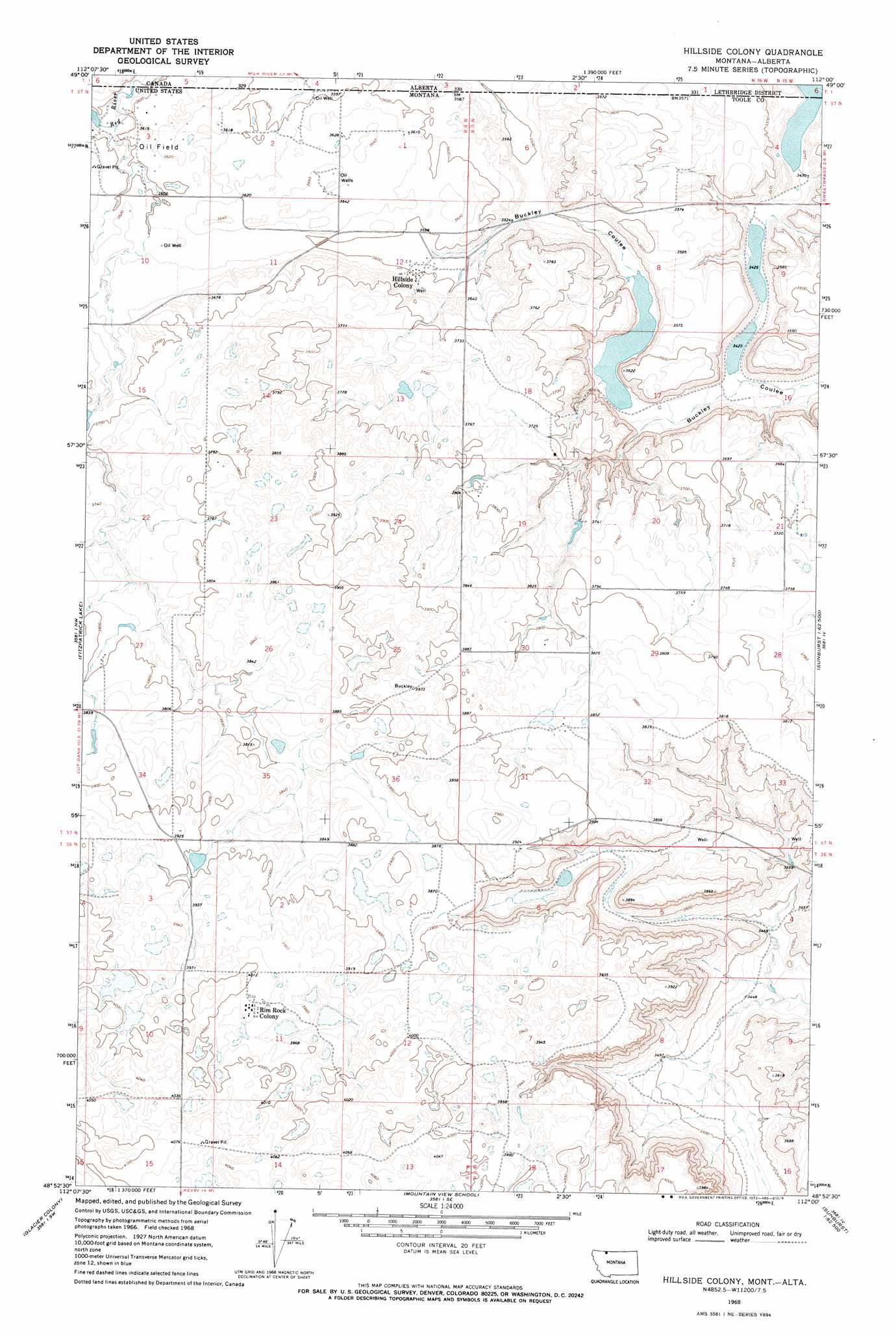
USGS Topo Quad 48112h1 - 1:24,000 scale
| Topo Map Name: | Hillside Colony |
| USGS Topo Quad ID: | 48112h1 |
| Print Size: | ca. 21 1/4" wide x 27" high |
| Southeast Coordinates: | 48.875° N latitude / 112° W longitude |
| Map Center Coordinates: | 48.9375° N latitude / 112.0625° W longitude |
| U.S. State: | MT |
| Filename: | o48112h1.jpg |
| Download Map JPG Image: | Hillside Colony topo map 1:24,000 scale |
| Map Type: | Topographic |
| Topo Series: | 7.5´ |
| Map Scale: | 1:24,000 |
| Source of Map Images: | United States Geological Survey (USGS) |
| Alternate Map Versions: |
Hillside Colony MT 1968, updated 1972 Download PDF Buy paper map Hillside Colony MT 2011 Download PDF Buy paper map Hillside Colony MT 2014 Download PDF Buy paper map |
1:24,000 Topo Quads surrounding Hillside Colony
Headlight Butte Ne |
Fitzpatrick Lake |
Hillside Colony |
Sunburst |
Willshaw Flats |
Headlight Butte |
Glacier Colony |
Mountain View School |
Kevin North |
Ferdig |
Cut Bank |
Ethridge Nw |
Aloe |
Kevin South |
Oilmont |
> Back to 48112e1 at 1:100,000 scale
> Back to 48112a1 at 1:250,000 scale
> Back to U.S. Topo Maps home
Hillside Colony topo map: Gazetteer
Hillside Colony: Dams
Brady Lakes Dam elevation 1086m 3562′GJP Suta Dam elevation 1217m 3992′
Hillkleberry Coulee Dam elevation 1137m 3730′
Hillside Colony Dam elevation 1099m 3605′
Looney Tuney Dam elevation 1184m 3884′
Miss Easy Pride Dam elevation 1218m 3996′
Hillside Colony: Lakes
Benton Trail Lakes elevation 1239m 4064′Davis Lakes elevation 1224m 4015′
Hemmings Lake elevation 1111m 3645′
Twin Lakes elevation 1116m 3661′
Hillside Colony: Populated Places
Hillside Colony elevation 1096m 3595′Rim Rock Colony elevation 1216m 3989′
Hillside Colony: Reservoirs
Eyraud Lakes elevation 1086m 3562′Grassy Lake elevation 1046m 3431′
Hillside Colony: Valleys
Farrell Coulee elevation 1084m 3556′Halfway Coulee elevation 1048m 3438′
Johns Coulee elevation 1139m 3736′
Mansfield Coulee elevation 1163m 3815′
Mars Coulee elevation 1153m 3782′
Rocky Ridge Coulee elevation 1089m 3572′
Treadwell Coulee elevation 1147m 3763′
Hillside Colony: Wells
36N03W06BA__01 Well elevation 1197m 3927′36N03W18AB__01 Well elevation 1204m 3950′
36N04W11BB__01 Well elevation 1220m 4002′
36N04W11DD__01 Well elevation 1224m 4015′
36N04W14AA__01 Well elevation 1224m 4015′
36N04W14AB__01 Well elevation 1217m 3992′
36N04W14AB__02 Well elevation 1217m 3992′
36N04W14AC__01 Well elevation 1221m 4005′
36N04W14AD__01 Well elevation 1237m 4058′
36N04W15AC__01 Well elevation 1242m 4074′
37N03W07BA__01 Well elevation 1079m 3540′
37N03W17DB__01 Well elevation 1055m 3461′
37N03W21ACB_01 Well elevation 1122m 3681′
37N03W21BD__01 Well elevation 1131m 3710′
37N03W21BD__02 Well elevation 1131m 3710′
37N03W21DB__01 Well elevation 1140m 3740′
37N03W30ACC_01 Well elevation 1166m 3825′
37N03W31AA__01 Well elevation 1181m 3874′
37N03W32DD__01 Well elevation 1140m 3740′
37N03W33BC__01 Well elevation 1143m 3750′
37N04W01CB__01 Well elevation 1111m 3645′
37N04W01CB__02 Well elevation 1111m 3645′
37N04W01DB__01 Well elevation 1103m 3618′
37N04W02DD__01 Well elevation 1116m 3661′
37N04W02DD__02 Well elevation 1116m 3661′
37N04W02DDC_01 Well elevation 1111m 3645′
37N04W12BA__01 Well elevation 1103m 3618′
37N04W12DB__01 Well elevation 1103m 3618′
37N04W12DB__02 Well elevation 1103m 3618′
37N04W15BC__01 Well elevation 1121m 3677′
37N04W25CC__01 Well elevation 1188m 3897′
37N04W27CB__01 Well elevation 1159m 3802′
37N04W27CB__02 Well elevation 1159m 3802′
37N04W34DD__01 Well elevation 1196m 3923′
Hillside Colony digital topo map on disk
Buy this Hillside Colony topo map showing relief, roads, GPS coordinates and other geographical features, as a high-resolution digital map file on DVD: