Crescent Cliff Topo Map Montana
To zoom in, hover over the map of Crescent Cliff
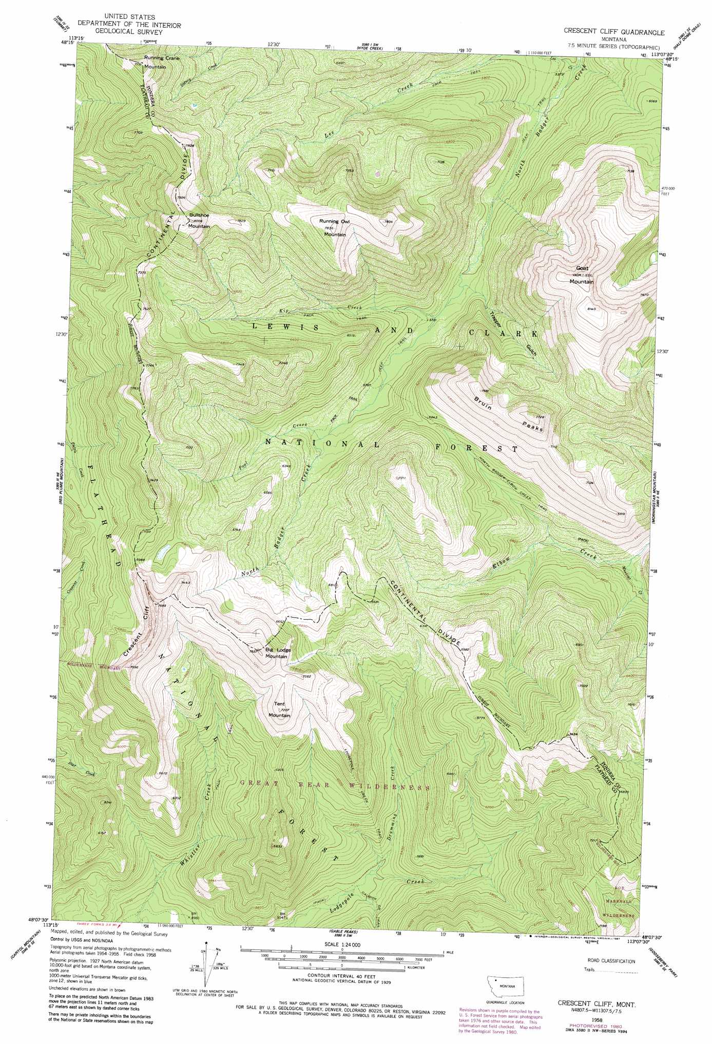
USGS Topo Quad 48113b2 - 1:24,000 scale
| Topo Map Name: | Crescent Cliff |
| USGS Topo Quad ID: | 48113b2 |
| Print Size: | ca. 21 1/4" wide x 27" high |
| Southeast Coordinates: | 48.125° N latitude / 113.125° W longitude |
| Map Center Coordinates: | 48.1875° N latitude / 113.1875° W longitude |
| U.S. State: | MT |
| Filename: | o48113b2.jpg |
| Download Map JPG Image: | Crescent Cliff topo map 1:24,000 scale |
| Map Type: | Topographic |
| Topo Series: | 7.5´ |
| Map Scale: | 1:24,000 |
| Source of Map Images: | United States Geological Survey (USGS) |
| Alternate Map Versions: |
Crescent Cliff MT 1958, updated 1960 Download PDF Buy paper map Crescent Cliff MT 1958, updated 1975 Download PDF Buy paper map Crescent Cliff MT 1958, updated 1981 Download PDF Buy paper map Crescent Cliff MT 1995, updated 1997 Download PDF Buy paper map Crescent Cliff MT 2011 Download PDF Buy paper map Crescent Cliff MT 2014 Download PDF Buy paper map |
| FStopo: | US Forest Service topo Crescent Cliff is available: Download FStopo PDF Download FStopo TIF |
1:24,000 Topo Quads surrounding Crescent Cliff
Mount Rockwell |
Squaw Mountain |
East Glacier Park |
Big Rock |
Magee Ranch |
Blacktail |
Summit |
Hyde Creek |
Half Dome Crag |
Mitten Lake |
Mount Bradley |
Red Plume Mountain |
Crescent Cliff |
Morningstar Mountain |
Swift Reservoir |
Horseshoe Peak |
Capitol Mountain |
Gable Peaks |
Gooseberry Peak |
Gateway Pass |
Spotted Bear Mountain |
Whitcomb Peak |
Trilobite Peak |
Pentagon Mountain |
Porphyry Reef |
> Back to 48113a1 at 1:100,000 scale
> Back to 48112a1 at 1:250,000 scale
> Back to U.S. Topo Maps home
Crescent Cliff topo map: Gazetteer
Crescent Cliff: Cliffs
Crescent Cliff elevation 2191m 7188′Crescent Cliff: Streams
Drumming Creek elevation 1583m 5193′Kip Creek elevation 1732m 5682′
Lee Creek elevation 1673m 5488′
Muskrat Creek elevation 1679m 5508′
Pool Creek elevation 1786m 5859′
Crescent Cliff: Summits
Big Lodge Mountain elevation 2317m 7601′Bruin Peaks elevation 2348m 7703′
Bullshoe Mountain elevation 2441m 8008′
Goat Mountain elevation 2494m 8182′
Running Crane Mountain elevation 2361m 7746′
Running Owl Mountain elevation 2386m 7828′
Tent Mountain elevation 2191m 7188′
Crescent Cliff: Trails
Calbick Creek Trail elevation 1647m 5403′Lodgepole Creek Trail elevation 1888m 6194′
North Badger-Elbow Creek Trail elevation 1801m 5908′
Crescent Cliff: Valleys
Trapper Gulch elevation 1717m 5633′Crescent Cliff digital topo map on disk
Buy this Crescent Cliff topo map showing relief, roads, GPS coordinates and other geographical features, as a high-resolution digital map file on DVD: