Felix Peak Topo Map Montana
To zoom in, hover over the map of Felix Peak
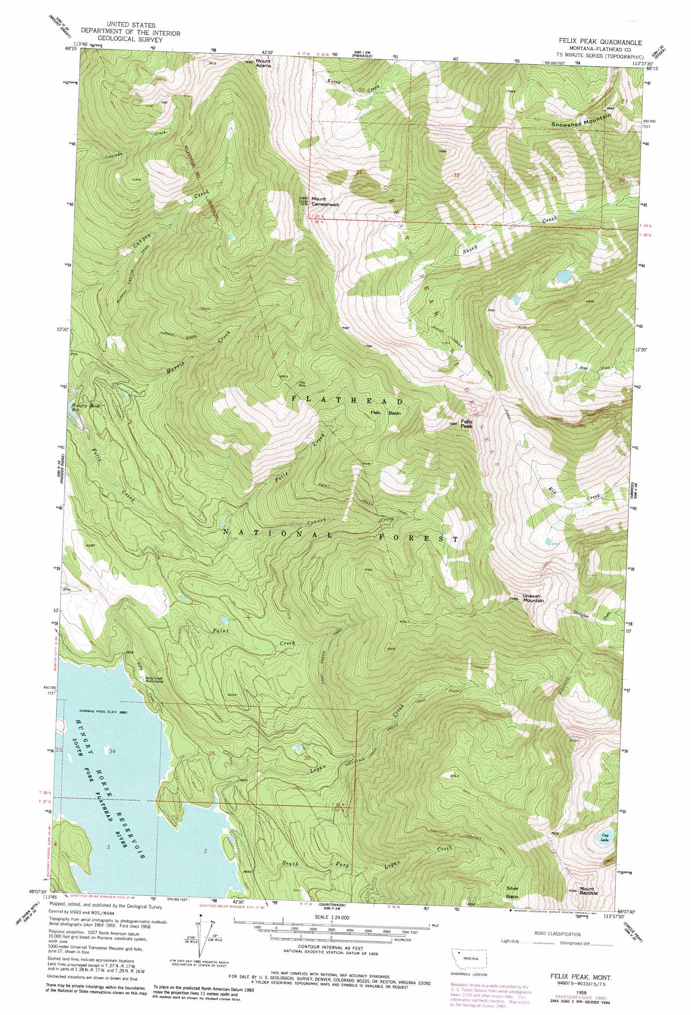
USGS Topo Quad 48113b6 - 1:24,000 scale
| Topo Map Name: | Felix Peak |
| USGS Topo Quad ID: | 48113b6 |
| Print Size: | ca. 21 1/4" wide x 27" high |
| Southeast Coordinates: | 48.125° N latitude / 113.625° W longitude |
| Map Center Coordinates: | 48.1875° N latitude / 113.6875° W longitude |
| U.S. State: | MT |
| Filename: | o48113b6.jpg |
| Download Map JPG Image: | Felix Peak topo map 1:24,000 scale |
| Map Type: | Topographic |
| Topo Series: | 7.5´ |
| Map Scale: | 1:24,000 |
| Source of Map Images: | United States Geological Survey (USGS) |
| Alternate Map Versions: |
Felix Peak MT 1958, updated 1960 Download PDF Buy paper map Felix Peak MT 1958, updated 1975 Download PDF Buy paper map Felix Peak MT 1958, updated 1981 Download PDF Buy paper map Felix Peak MT 1994, updated 1997 Download PDF Buy paper map Felix Peak MT 2011 Download PDF Buy paper map Felix Peak MT 2014 Download PDF Buy paper map |
| FStopo: | US Forest Service topo Felix Peak is available: Download FStopo PDF Download FStopo TIF |
1:24,000 Topo Quads surrounding Felix Peak
West Glacier |
Nyack |
Stanton Lake |
Mount Saint Nicholas |
Mount Rockwell |
Nyack Sw |
Mount Grant |
Pinnacle |
Essex |
Blacktail |
Jewel Basin |
Pioneer Ridge |
Felix Peak |
Nimrod |
Mount Bradley |
Crater Lake |
Big Hawk Mountain |
Quintonkon |
Circus Peak |
Horseshoe Peak |
Yew Creek |
Swan Lake |
Connor Creek |
Tin Creek |
Spotted Bear Mountain |
> Back to 48113a1 at 1:100,000 scale
> Back to 48112a1 at 1:250,000 scale
> Back to U.S. Topo Maps home
Felix Peak topo map: Gazetteer
Felix Peak: Basins
Felix Basin elevation 1885m 6184′Silver Basin elevation 1911m 6269′
Felix Peak: Lakes
Cup Lake elevation 1934m 6345′Felix Peak: Mines
Felix Mine elevation 2018m 6620′Felix Mine elevation 2022m 6633′
Silver Basin Mine elevation 1926m 6318′
Felix Peak: Streams
Betty Creek elevation 1096m 3595′Felix Creek elevation 1094m 3589′
Harris Creek elevation 1094m 3589′
Logan Creek elevation 1086m 3562′
Paint Creek elevation 1093m 3585′
South Fork Logan Creek elevation 1088m 3569′
Unawah Creek elevation 1218m 3996′
Felix Peak: Summits
Canyon Point elevation 1919m 6295′Felix Peak elevation 2435m 7988′
Mount Adams elevation 2324m 7624′
Mount Baptiste elevation 2554m 8379′
Mount Cameahwait elevation 2371m 7778′
Snowshed Mountain elevation 2258m 7408′
Unawah Mountain elevation 2394m 7854′
Felix Peak: Trails
Baptiste Lookout Trail elevation 1779m 5836′Felix Basin Trail elevation 1274m 4179′
Harris Ridge Trail elevation 1713m 5620′
Murray Canyon Trail elevation 1496m 4908′
Paint Creek Trail elevation 1675m 5495′
Sheep Creek Trail elevation 1947m 6387′
Felix Peak digital topo map on disk
Buy this Felix Peak topo map showing relief, roads, GPS coordinates and other geographical features, as a high-resolution digital map file on DVD: