East Glacier Park Topo Map Montana
To zoom in, hover over the map of East Glacier Park
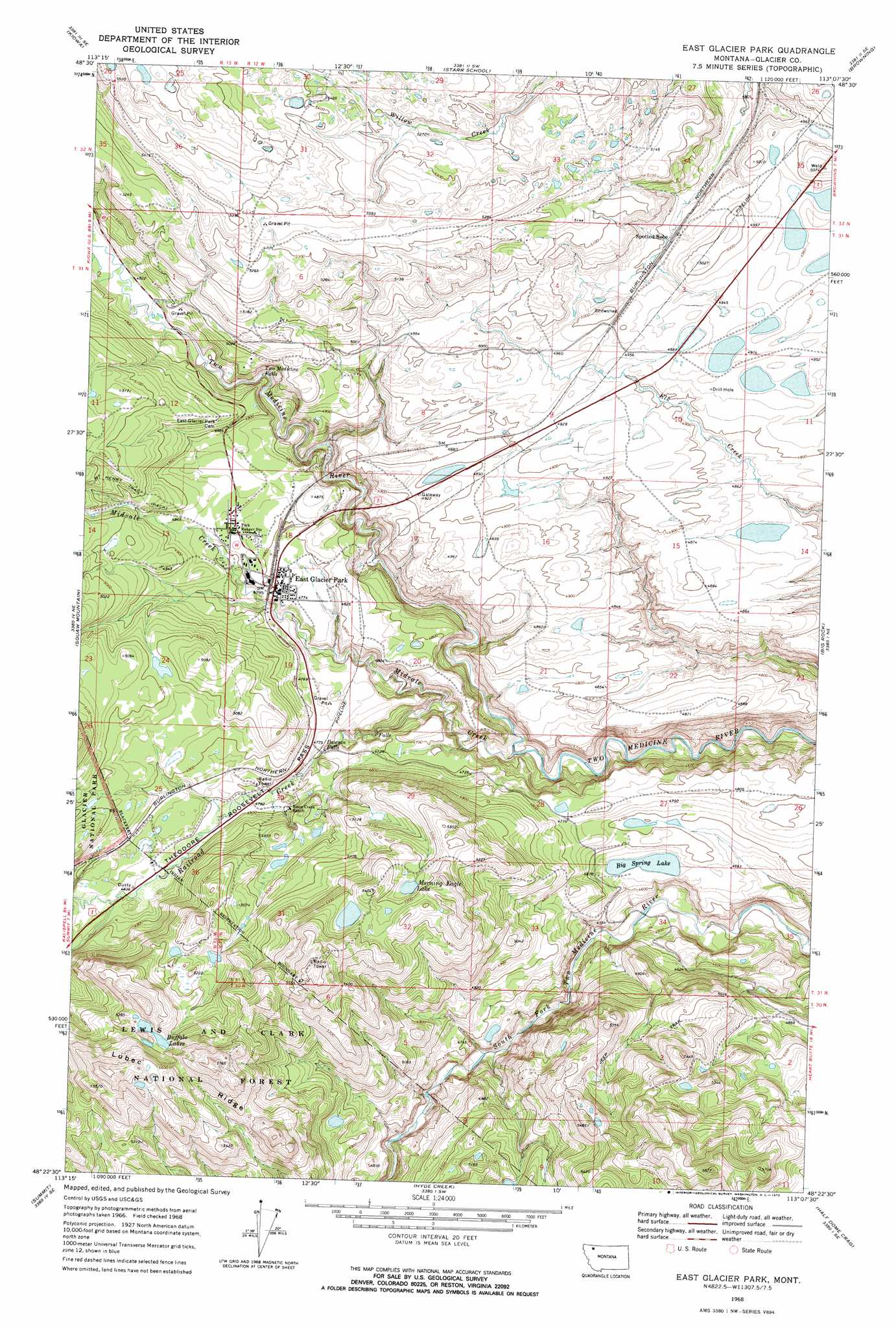
USGS Topo Quad 48113d2 - 1:24,000 scale
| Topo Map Name: | East Glacier Park |
| USGS Topo Quad ID: | 48113d2 |
| Print Size: | ca. 21 1/4" wide x 27" high |
| Southeast Coordinates: | 48.375° N latitude / 113.125° W longitude |
| Map Center Coordinates: | 48.4375° N latitude / 113.1875° W longitude |
| U.S. State: | MT |
| Filename: | o48113d2.jpg |
| Download Map JPG Image: | East Glacier Park topo map 1:24,000 scale |
| Map Type: | Topographic |
| Topo Series: | 7.5´ |
| Map Scale: | 1:24,000 |
| Source of Map Images: | United States Geological Survey (USGS) |
| Alternate Map Versions: |
East Glacier Park MT 1968, updated 1972 Download PDF Buy paper map East Glacier Park MT 1995, updated 1997 Download PDF Buy paper map East Glacier Park MT 2011 Download PDF Buy paper map East Glacier Park MT 2014 Download PDF Buy paper map |
| FStopo: | US Forest Service topo East Glacier Park is available: Download FStopo PDF Download FStopo TIF |
1:24,000 Topo Quads surrounding East Glacier Park
Saint Mary |
Fox Creek |
Horse Lake |
Browning Ne |
Sharp Lake |
Cut Bank Pass |
Kiowa |
Starr School |
Browning |
Blackfoot |
Mount Rockwell |
Squaw Mountain |
East Glacier Park |
Big Rock |
Magee Ranch |
Blacktail |
Summit |
Hyde Creek |
Half Dome Crag |
Mitten Lake |
Mount Bradley |
Red Plume Mountain |
Crescent Cliff |
Morningstar Mountain |
Swift Reservoir |
> Back to 48113a1 at 1:100,000 scale
> Back to 48112a1 at 1:250,000 scale
> Back to U.S. Topo Maps home
East Glacier Park topo map: Gazetteer
East Glacier Park: Bridges
Midvale Creek Bridge elevation 1581m 5187′East Glacier Park: Falls
Dawson Falls elevation 1443m 4734′Two Medicine Falls elevation 1450m 4757′
East Glacier Park: Lakes
Big Spring Lake elevation 1414m 4639′Buffalo Lakes elevation 1638m 5374′
Morning Eagle Lake elevation 1595m 5232′
East Glacier Park: Populated Places
East Glacier Park elevation 1462m 4796′East Glacier Park Village elevation 1470m 4822′
East Glacier Park: Post Offices
East Glacier Park Post Office elevation 1459m 4786′East Glacier Park: Ridges
Lubec Ridge elevation 1669m 5475′East Glacier Park: Springs
32N12W34CBCD01 Spring elevation 1528m 5013′East Glacier Park: Streams
Midvale Creek elevation 1375m 4511′Railroad Creek elevation 1394m 4573′
East Glacier Park digital topo map on disk
Buy this East Glacier Park topo map showing relief, roads, GPS coordinates and other geographical features, as a high-resolution digital map file on DVD: