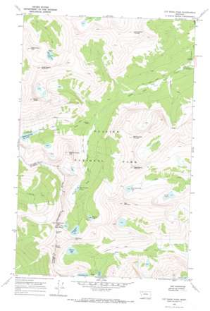
Cut Bank Pass Topo Map Montana
To zoom in, hover over the map of Cut Bank Pass
USGS Topo Quad 48113e4 - 1:24,000 scale
| Topo Map Name: | Cut Bank Pass |
| USGS Topo Quad ID: | 48113e4 |
| Print Size: | ca. 21 1/4" wide x 27" high |
| Southeast Coordinates: | 48.5° N latitude / 113.375° W longitude |
| Map Center Coordinates: | 48.5625° N latitude / 113.4375° W longitude |
| U.S. State: | MT |
| Filename: | o48113e4.jpg |
| Download Map JPG Image: | Cut Bank Pass topo map 1:24,000 scale |
| Map Type: | Topographic |
| Topo Series: | 7.5´ |
| Map Scale: | 1:24,000 |
| Source of Map Images: | United States Geological Survey (USGS) |
| Alternate Map Versions: |
Cut Bank Pass MT 1968, updated 1971 Download PDF Buy paper map Cut Bank Pass MT 1968, updated 1971 Download PDF Buy paper map Cut Bank Pass MT 2011 Download PDF Buy paper map Cut Bank Pass MT 2014 Download PDF Buy paper map |
1:24,000 Topo Quads surrounding Cut Bank Pass
> Back to 48113e1 at 1:100,000 scale
> Back to 48112a1 at 1:250,000 scale
> Back to U.S. Topo Maps home
Cut Bank Pass topo map: Gazetteer
Cut Bank Pass: Falls
Atlantic Falls elevation 1636m 5367′Cut Bank Pass: Gaps
Cut Bank Pass elevation 2398m 7867′Pitamakan Pass elevation 2299m 7542′
Cut Bank Pass: Lakes
Boy Lake elevation 1931m 6335′Katoya Lake elevation 1942m 6371′
Lonely Lakes elevation 2175m 7135′
Medicine Grizzly Lake elevation 1697m 5567′
Medicine Owl Lake elevation 2076m 6811′
Morning Star Lake elevation 1758m 5767′
Oldman Lake elevation 2027m 6650′
Pitamakan Lake elevation 2076m 6811′
Running Crane Lake elevation 2242m 7355′
Seven Winds of the Lake elevation 2126m 6975′
Sky Lake elevation 2139m 7017′
Cut Bank Pass: Streams
Atlantic Creek elevation 1630m 5347′Cut Bank Pass: Summits
Amphitheater Mountain elevation 2639m 8658′Bad Marriage Mountain elevation 2542m 8339′
Eagle Plume Mountain elevation 2649m 8690′
Kupunkamint Mountain elevation 2671m 8763′
McClintock Peak elevation 2519m 8264′
Medicine Grizzly Peak elevation 2485m 8152′
Medicine Owl Peak elevation 2520m 8267′
Mount James elevation 2857m 9373′
Mount Morgan elevation 2653m 8704′
Red Mountain elevation 2856m 9370′
Cut Bank Pass: Trails
Cut Bank Pass Trail elevation 1640m 5380′Medicine Grizzly Trail elevation 1706m 5597′
Pitamakan Pass Trail elevation 1920m 6299′
Cut Bank Pass digital topo map on disk
Buy this Cut Bank Pass topo map showing relief, roads, GPS coordinates and other geographical features, as a high-resolution digital map file on DVD:


