Mount Cannon Topo Map Montana
To zoom in, hover over the map of Mount Cannon
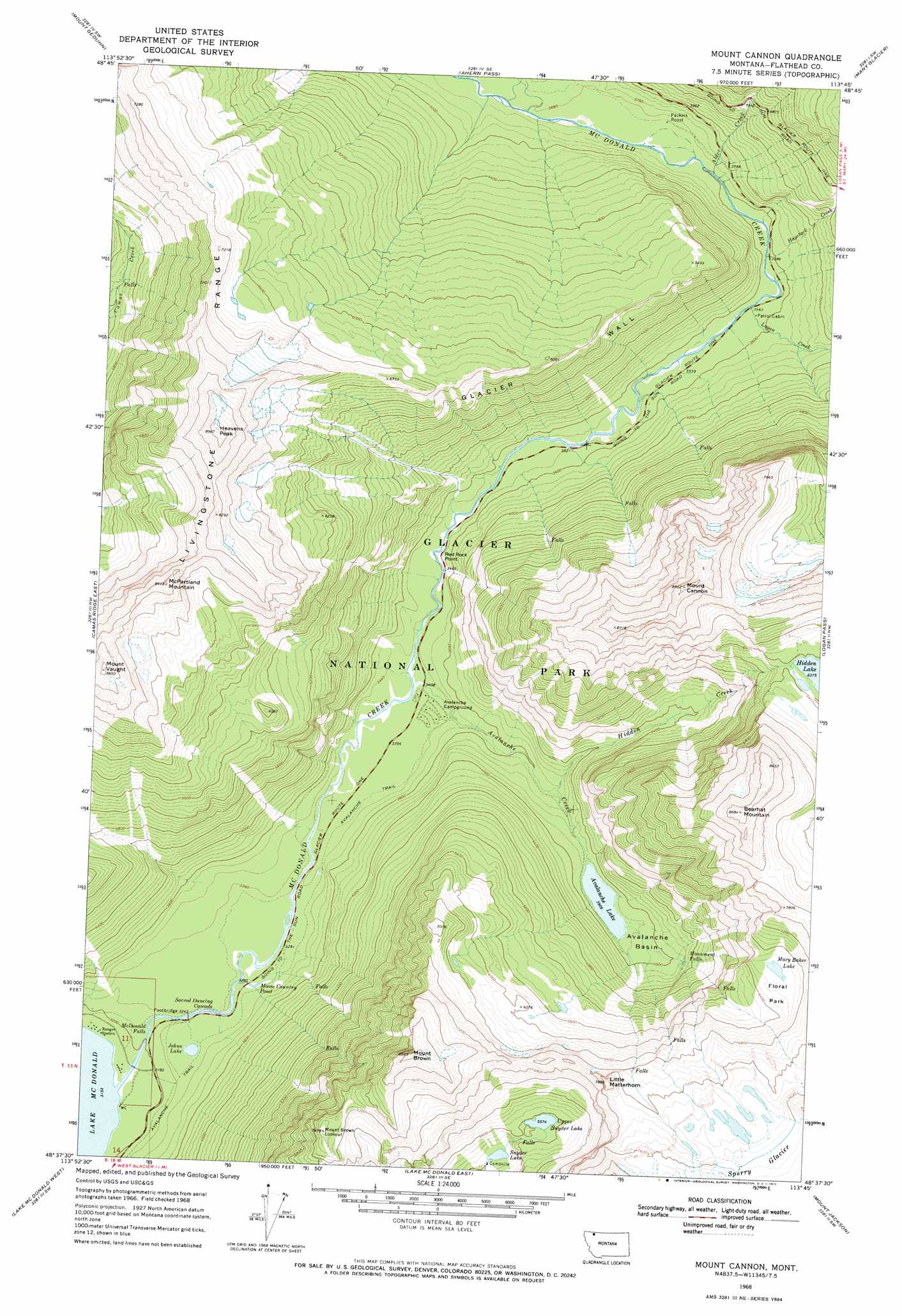
USGS Topo Quad 48113f7 - 1:24,000 scale
| Topo Map Name: | Mount Cannon |
| USGS Topo Quad ID: | 48113f7 |
| Print Size: | ca. 21 1/4" wide x 27" high |
| Southeast Coordinates: | 48.625° N latitude / 113.75° W longitude |
| Map Center Coordinates: | 48.6875° N latitude / 113.8125° W longitude |
| U.S. State: | MT |
| Filename: | o48113f7.jpg |
| Download Map JPG Image: | Mount Cannon topo map 1:24,000 scale |
| Map Type: | Topographic |
| Topo Series: | 7.5´ |
| Map Scale: | 1:24,000 |
| Source of Map Images: | United States Geological Survey (USGS) |
| Alternate Map Versions: |
Mount Cannon MT 1968, updated 1971 Download PDF Buy paper map Mount Cannon MT 1968, updated 1971 Download PDF Buy paper map Mount Cannon MT 2011 Download PDF Buy paper map Mount Cannon MT 2014 Download PDF Buy paper map |
1:24,000 Topo Quads surrounding Mount Cannon
Mount Carter |
Porcupine Ridge |
Mount Cleveland |
Gable Mountain |
Chief Mountain |
Vulture Peak |
Mount Geduhn |
Ahern Pass |
Many Glacier |
Lake Sherburne |
Camas Ridge West |
Camas Ridge East |
Mount Cannon |
Logan Pass |
Rising Sun |
Mcgee Meadow |
Lake Mcdonald West |
Lake Mcdonald East |
Mount Jackson |
Mount Stimson |
Hungry Horse |
West Glacier |
Nyack |
Stanton Lake |
Mount Saint Nicholas |
> Back to 48113e1 at 1:100,000 scale
> Back to 48112a1 at 1:250,000 scale
> Back to U.S. Topo Maps home
Mount Cannon topo map: Gazetteer
Mount Cannon: Basins
Avalanche Basin elevation 1213m 3979′Floral Park elevation 1997m 6551′
Mount Cannon: Cliffs
Glacier Wall elevation 1804m 5918′Mount Cannon: Falls
McDonald Falls elevation 983m 3225′Monument Falls elevation 1302m 4271′
Sacred Dancing Cascade elevation 1003m 3290′
Mount Cannon: Lakes
Avalanche Lake elevation 1192m 3910′Johns Lake elevation 1020m 3346′
Mary Baker Lake elevation 2013m 6604′
Moose Country Pond elevation 1013m 3323′
Snyder Lake elevation 1599m 5246′
Upper Snyder Lake elevation 1700m 5577′
Mount Cannon: Parks
Glacier National Park elevation 1404m 4606′Waterton-Glacier International Peace Park elevation 1822m 5977′
Mount Cannon: Populated Places
Geduhn (historical) elevation 975m 3198′Packers Roost elevation 1119m 3671′
Red Rock Point elevation 1081m 3546′
Mount Cannon: Streams
Alder Creek elevation 1118m 3667′Avalanche Creek elevation 1037m 3402′
Haystack Creek elevation 1089m 3572′
Hidden Creek elevation 1116m 3661′
Logan Creek elevation 1084m 3556′
Mount Cannon: Summits
Bearhat Mountain elevation 2644m 8674′Heavens Peak elevation 2697m 8848′
Little Matterhorn elevation 2320m 7611′
McPartland Mountain elevation 2487m 8159′
Mount Brown elevation 2572m 8438′
Mount Cannon elevation 2691m 8828′
Mount Vaught elevation 2679m 8789′
Mount Cannon: Trails
Avalanche Trail elevation 1046m 3431′Mount Cannon digital topo map on disk
Buy this Mount Cannon topo map showing relief, roads, GPS coordinates and other geographical features, as a high-resolution digital map file on DVD: