Lake Sherburne Topo Map Montana
To zoom in, hover over the map of Lake Sherburne
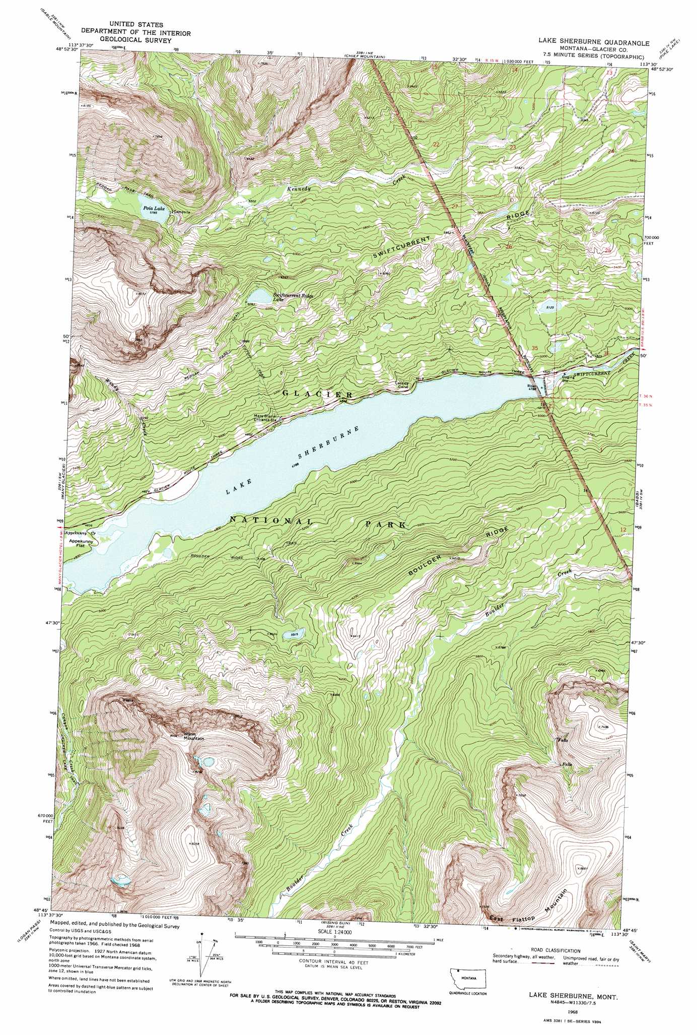
USGS Topo Quad 48113g5 - 1:24,000 scale
| Topo Map Name: | Lake Sherburne |
| USGS Topo Quad ID: | 48113g5 |
| Print Size: | ca. 21 1/4" wide x 27" high |
| Southeast Coordinates: | 48.75° N latitude / 113.5° W longitude |
| Map Center Coordinates: | 48.8125° N latitude / 113.5625° W longitude |
| U.S. State: | MT |
| Filename: | o48113g5.jpg |
| Download Map JPG Image: | Lake Sherburne topo map 1:24,000 scale |
| Map Type: | Topographic |
| Topo Series: | 7.5´ |
| Map Scale: | 1:24,000 |
| Source of Map Images: | United States Geological Survey (USGS) |
| Alternate Map Versions: |
Lake Sherburne MT 1968, updated 1972 Download PDF Buy paper map Lake Sherburne MT 1968, updated 1972 Download PDF Buy paper map Lake Sherburne MT 2011 Download PDF Buy paper map Lake Sherburne MT 2014 Download PDF Buy paper map |
1:24,000 Topo Quads surrounding Lake Sherburne
Mount Cleveland |
Gable Mountain |
Chief Mountain |
Pike Lake |
Goose Lake |
Ahern Pass |
Many Glacier |
Lake Sherburne |
Babb |
Duck Lake |
Mount Cannon |
Logan Pass |
Rising Sun |
Saint Mary |
Fox Creek |
Lake Mcdonald East |
Mount Jackson |
Mount Stimson |
Cut Bank Pass |
Kiowa |
> Back to 48113e1 at 1:100,000 scale
> Back to 48112a1 at 1:250,000 scale
> Back to U.S. Topo Maps home
Lake Sherburne topo map: Gazetteer
Lake Sherburne: Dams
Lake Sherburne Dam elevation 1494m 4901′Lake Sherburne: Lakes
Poia Lake elevation 1765m 5790′Swiftcurrent Ridge Lake elevation 1858m 6095′
Lake Sherburne: Populated Places
Altyn (historical) elevation 1461m 4793′Cassidy Curve elevation 1472m 4829′
Lake Sherburne: Post Offices
Altyn Post Office (historical) elevation 1461m 4793′Sherburne Post Office (historical) elevation 1475m 4839′
Lake Sherburne: Reservoirs
Lake Sherburne elevation 1464m 4803′Lake Sherburne: Ridges
Boulder Ridge elevation 1922m 6305′Lake Sherburne: Streams
Apikuni Creek elevation 1461m 4793′Canyon Creek elevation 1461m 4793′
Windy Creek elevation 1461m 4793′
Lake Sherburne: Summits
Wynn Mountain elevation 2559m 8395′Lake Sherburne: Trails
Boulder Ridge Trail elevation 1536m 5039′Cracker Lake Trail elevation 1658m 5439′
Cutoff Trail elevation 1685m 5528′
Lake Sherburne digital topo map on disk
Buy this Lake Sherburne topo map showing relief, roads, GPS coordinates and other geographical features, as a high-resolution digital map file on DVD: