Kila Topo Map Montana
To zoom in, hover over the map of Kila
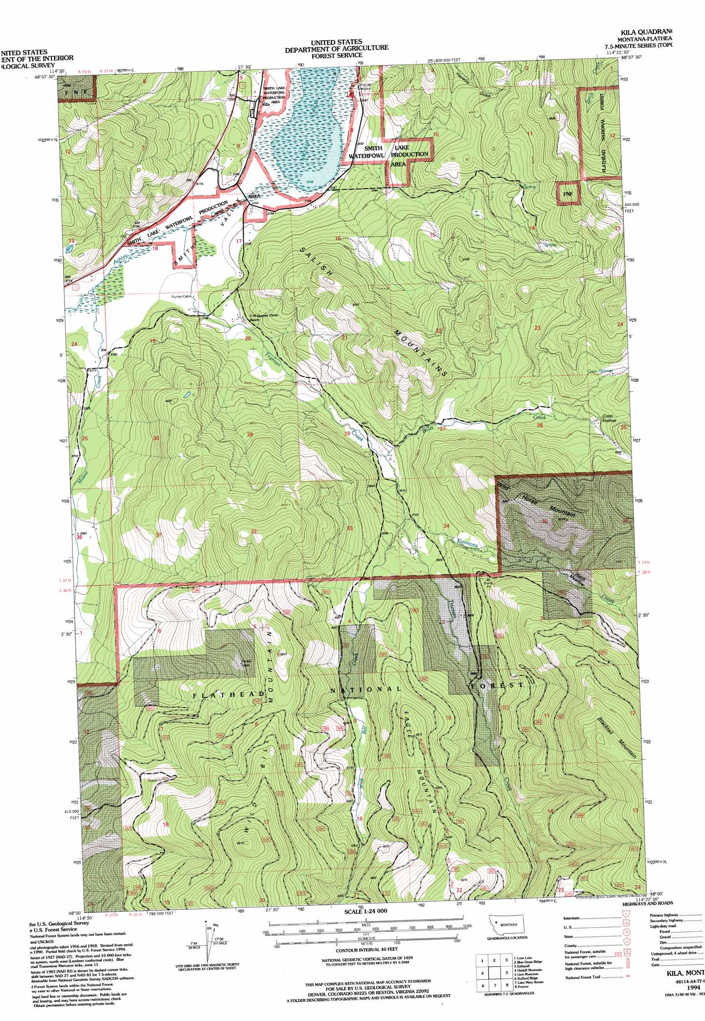
USGS Topo Quad 48114a4 - 1:24,000 scale
| Topo Map Name: | Kila |
| USGS Topo Quad ID: | 48114a4 |
| Print Size: | ca. 21 1/4" wide x 27" high |
| Southeast Coordinates: | 48° N latitude / 114.375° W longitude |
| Map Center Coordinates: | 48.0625° N latitude / 114.4375° W longitude |
| U.S. State: | MT |
| Filename: | o48114a4.jpg |
| Download Map JPG Image: | Kila topo map 1:24,000 scale |
| Map Type: | Topographic |
| Topo Series: | 7.5´ |
| Map Scale: | 1:24,000 |
| Source of Map Images: | United States Geological Survey (USGS) |
| Alternate Map Versions: |
Kila MT 1962, updated 1964 Download PDF Buy paper map Kila MT 1962, updated 1983 Download PDF Buy paper map Kila MT 1994, updated 1996 Download PDF Buy paper map Kila MT 2011 Download PDF Buy paper map Kila MT 2014 Download PDF Buy paper map |
| FStopo: | US Forest Service topo Kila is available: Download FStopo PDF Download FStopo TIF |
1:24,000 Topo Quads surrounding Kila
Ashley Mountain |
Lost Creek Divide |
Rhodes |
Rose Crossing |
Columbia Falls South |
Pleasant Valley Mountain |
Lone Lake |
Blue Grass Ridge |
Kalispell |
Creston |
Marion |
Haskill Mountain |
Kila |
Lion Mountain |
Somers |
Hubbart Reservoir |
Kofford Ridge |
Lake Mary Ronan |
Proctor |
Rollins |
Mill Pocket Creek |
Niarada |
Irvine Lookout Tower |
Elmo |
Wild Horse Island |
> Back to 48114a1 at 1:100,000 scale
> Back to 48114a1 at 1:250,000 scale
> Back to U.S. Topo Maps home
Kila topo map: Gazetteer
Kila: Basins
Coon Hollow elevation 1269m 4163′Kila: Flats
Hatch Meadow elevation 1294m 4245′Kila: Lakes
Smith Lake elevation 959m 3146′Kila: Parks
Smith Lake Waterfowl Production Area elevation 960m 3149′Kila: Populated Places
Kila elevation 973m 3192′Kila: Post Offices
Kila Post Office elevation 980m 3215′Murray Post Office (historical) elevation 991m 3251′
Kila: Ridges
Eagle Mountain elevation 1500m 4921′Kila: Springs
Coon Springs elevation 1328m 4356′Kila: Streams
Bales Creek elevation 1076m 3530′Emmons Creek elevation 1118m 3667′
Mount Creek elevation 959m 3146′
Truman Creek elevation 959m 3146′
Wild Bill Creek elevation 1125m 3690′
Kila: Summits
Wild Bill Mountain elevation 1831m 6007′Wild Horse Mountain elevation 1582m 5190′
Kila: Valleys
Jackson Draw elevation 967m 3172′Kila digital topo map on disk
Buy this Kila topo map showing relief, roads, GPS coordinates and other geographical features, as a high-resolution digital map file on DVD: