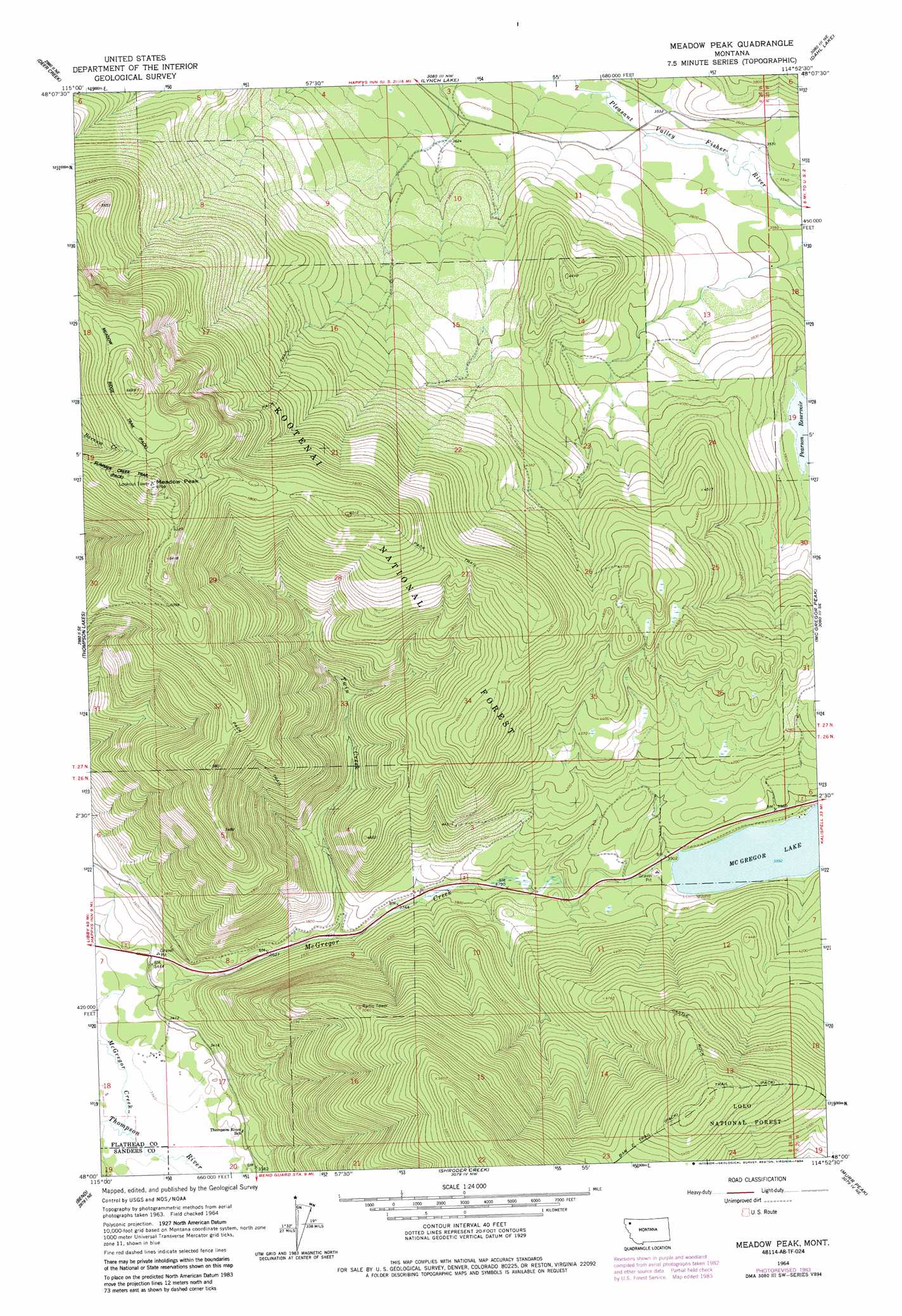
Meadow Peak Topo Map Montana
To zoom in, hover over the map of Meadow Peak
USGS Topo Quad 48114a8 - 1:24,000 scale
| Topo Map Name: | Meadow Peak |
| USGS Topo Quad ID: | 48114a8 |
| Print Size: | ca. 21 1/4" wide x 27" high |
| Southeast Coordinates: | 48° N latitude / 114.875° W longitude |
| Map Center Coordinates: | 48.0625° N latitude / 114.9375° W longitude |
| U.S. State: | MT |
| Filename: | o48114a8.jpg |
| Download Map JPG Image: | Meadow Peak topo map 1:24,000 scale |
| Map Type: | Topographic |
| Topo Series: | 7.5´ |
| Map Scale: | 1:24,000 |
| Source of Map Images: | United States Geological Survey (USGS) |
| Alternate Map Versions: |
Meadow Peak MT 1964, updated 1967 Download PDF Buy paper map Meadow Peak MT 1964, updated 1984 Download PDF Buy paper map Meadow Peak MT 1997, updated 2000 Download PDF Buy paper map Meadow Peak MT 2011 Download PDF Buy paper map Meadow Peak MT 2014 Download PDF Buy paper map |
| FStopo: | US Forest Service topo Meadow Peak is available: Download FStopo PDF Download FStopo TIF |
1:24,000 Topo Quads surrounding Meadow Peak
Richards Mountain |
Wolf Prairie |
Horse Hill |
Sylvia Lake |
Ashley Mountain |
Calx Mountain |
Deer Creek |
Lynch Lake |
Dahl Lake |
Pleasant Valley Mountain |
Loon Lake |
Thompson Lakes |
Meadow Peak |
Mcgregor Peak |
Marion |
Mantrap Fork |
Bend |
Shroder Creek |
Murr Peak |
Hubbart Reservoir |
Fishtrap Lake |
Richards Peak |
Cook Mountain |
Bassoo Peak |
Mill Pocket Creek |
> Back to 48114a1 at 1:100,000 scale
> Back to 48114a1 at 1:250,000 scale
> Back to U.S. Topo Maps home
Meadow Peak topo map: Gazetteer
Meadow Peak: Airports
Campbell Ranch Airport elevation 1018m 3339′Meadow Peak: Dams
Hardy Dam elevation 1157m 3795′Meadow Peak: Reservoirs
Pearson Reservoir elevation 1154m 3786′Meadow Peak: Streams
McGregor Creek elevation 1017m 3336′Twin Creek elevation 1122m 3681′
Meadow Peak: Summits
Meadow Peak elevation 2042m 6699′Meadow Peak digital topo map on disk
Buy this Meadow Peak topo map showing relief, roads, GPS coordinates and other geographical features, as a high-resolution digital map file on DVD: