Ashley Mountain Topo Map Montana
To zoom in, hover over the map of Ashley Mountain
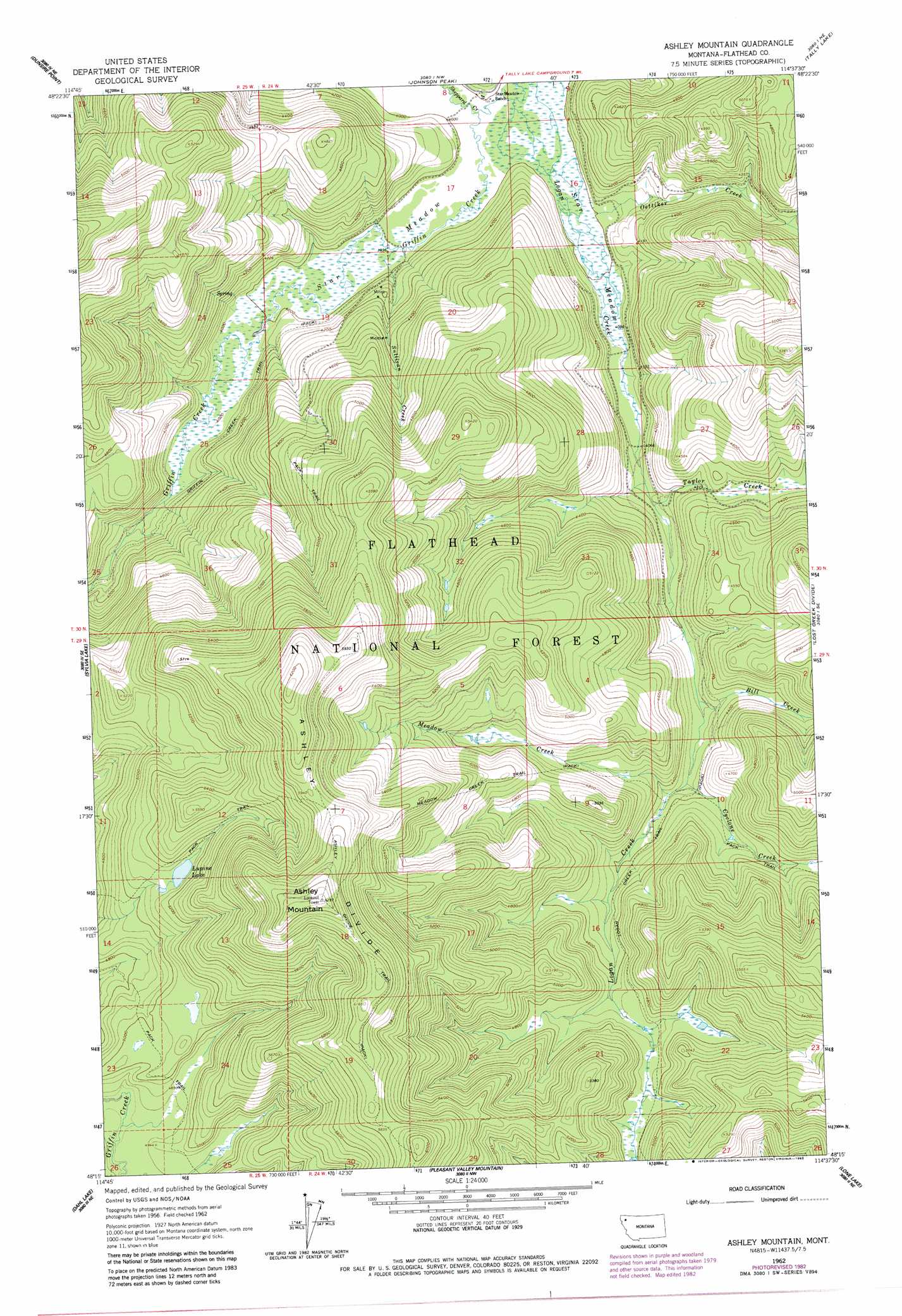
USGS Topo Quad 48114c6 - 1:24,000 scale
| Topo Map Name: | Ashley Mountain |
| USGS Topo Quad ID: | 48114c6 |
| Print Size: | ca. 21 1/4" wide x 27" high |
| Southeast Coordinates: | 48.25° N latitude / 114.625° W longitude |
| Map Center Coordinates: | 48.3125° N latitude / 114.6875° W longitude |
| U.S. State: | MT |
| Filename: | o48114c6.jpg |
| Download Map JPG Image: | Ashley Mountain topo map 1:24,000 scale |
| Map Type: | Topographic |
| Topo Series: | 7.5´ |
| Map Scale: | 1:24,000 |
| Source of Map Images: | United States Geological Survey (USGS) |
| Alternate Map Versions: |
Ashley Mountain MT 1962, updated 1964 Download PDF Buy paper map Ashley Mountain MT 1962, updated 1983 Download PDF Buy paper map Ashley Mountain MT 1994, updated 1997 Download PDF Buy paper map Ashley Mountain MT 2011 Download PDF Buy paper map Ashley Mountain MT 2014 Download PDF Buy paper map |
| FStopo: | US Forest Service topo Ashley Mountain is available: Download FStopo PDF Download FStopo TIF |
1:24,000 Topo Quads surrounding Ashley Mountain
Skillet Mountain |
Sunday Mountain |
Radnor |
Olney |
Werner Peak |
Bowen Lake |
Dunsire Point |
Johnson Peak |
Tally Lake |
Beaver Lake |
Horse Hill |
Sylvia Lake |
Ashley Mountain |
Lost Creek Divide |
Rhodes |
Lynch Lake |
Dahl Lake |
Pleasant Valley Mountain |
Lone Lake |
Blue Grass Ridge |
Meadow Peak |
Mcgregor Peak |
Marion |
Haskill Mountain |
Kila |
> Back to 48114a1 at 1:100,000 scale
> Back to 48114a1 at 1:250,000 scale
> Back to U.S. Topo Maps home
Ashley Mountain topo map: Gazetteer
Ashley Mountain: Flats
Star Meadow elevation 1215m 3986′Ashley Mountain: Lakes
Lupine Lake elevation 1556m 5104′Ashley Mountain: Mines
Copper King Mine elevation 1425m 4675′Ashley Mountain: Ranges
Salish Mountains elevation 1539m 5049′Ashley Mountain: Ridges
Ashley Divide elevation 1816m 5958′Ashley Mountain: Streams
Bill Creek elevation 1292m 4238′Cyclone Creek elevation 1311m 4301′
Griffin Creek elevation 1215m 3986′
Meadow Creek elevation 1325m 4347′
Oettiker Creek elevation 1219m 3999′
Sheppard Creek elevation 1216m 3989′
Sullivan Creek elevation 1215m 3986′
Taylor Creek elevation 1245m 4084′
Ashley Mountain: Summits
Ashley Mountain elevation 1918m 6292′Ashley Mountain: Trails
Ashley Divide Trail elevation 1847m 6059′Griffin Creek Trail elevation 1250m 4101′
Logan Creek Trail elevation 1397m 4583′
Lupine Lake Trail elevation 1568m 5144′
Meadow Creek Trail elevation 1532m 5026′
Ashley Mountain digital topo map on disk
Buy this Ashley Mountain topo map showing relief, roads, GPS coordinates and other geographical features, as a high-resolution digital map file on DVD: