Tally Lake Topo Map Montana
To zoom in, hover over the map of Tally Lake
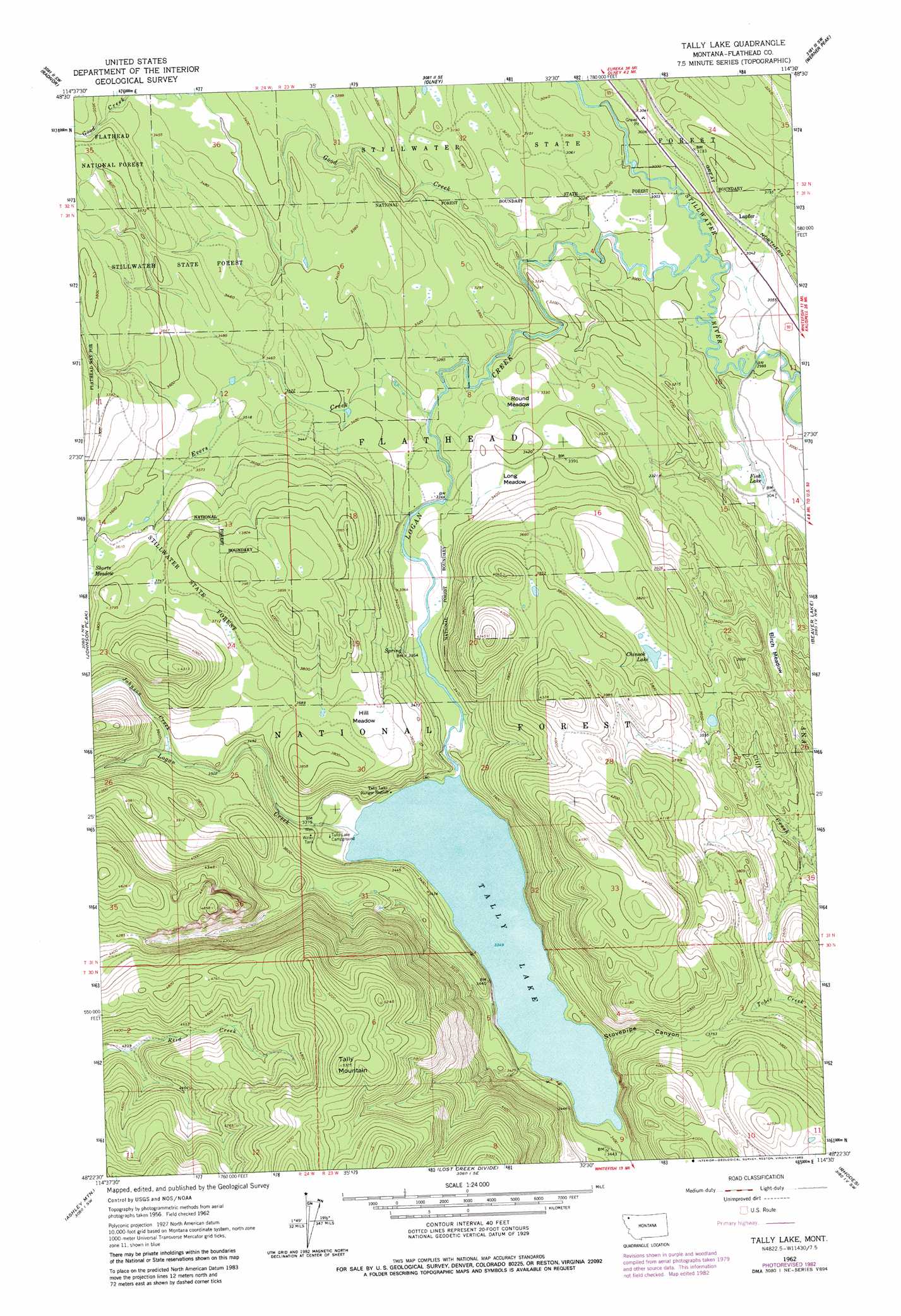
USGS Topo Quad 48114d5 - 1:24,000 scale
| Topo Map Name: | Tally Lake |
| USGS Topo Quad ID: | 48114d5 |
| Print Size: | ca. 21 1/4" wide x 27" high |
| Southeast Coordinates: | 48.375° N latitude / 114.5° W longitude |
| Map Center Coordinates: | 48.4375° N latitude / 114.5625° W longitude |
| U.S. State: | MT |
| Filename: | o48114d5.jpg |
| Download Map JPG Image: | Tally Lake topo map 1:24,000 scale |
| Map Type: | Topographic |
| Topo Series: | 7.5´ |
| Map Scale: | 1:24,000 |
| Source of Map Images: | United States Geological Survey (USGS) |
| Alternate Map Versions: |
Tally Lake MT 1962, updated 1964 Download PDF Buy paper map Tally Lake MT 1962, updated 1979 Download PDF Buy paper map Tally Lake MT 1962, updated 1983 Download PDF Buy paper map Tally Lake MT 1994, updated 1997 Download PDF Buy paper map Tally Lake MT 1994, updated 1997 Download PDF Buy paper map Tally Lake MT 2011 Download PDF Buy paper map Tally Lake MT 2014 Download PDF Buy paper map |
| FStopo: | US Forest Service topo Tally Lake is available: Download FStopo PDF Download FStopo TIF |
1:24,000 Topo Quads surrounding Tally Lake
Stryker |
Bull Lake |
Upper Whitefish Lake |
Moose Peak |
Cyclone Lake |
Sunday Mountain |
Radnor |
Olney |
Werner Peak |
Skookoleel Creek |
Dunsire Point |
Johnson Peak |
Tally Lake |
Beaver Lake |
Whitefish |
Sylvia Lake |
Ashley Mountain |
Lost Creek Divide |
Rhodes |
Rose Crossing |
Dahl Lake |
Pleasant Valley Mountain |
Lone Lake |
Blue Grass Ridge |
Kalispell |
> Back to 48114a1 at 1:100,000 scale
> Back to 48114a1 at 1:250,000 scale
> Back to U.S. Topo Maps home
Tally Lake topo map: Gazetteer
Tally Lake: Flats
Birch Meadow elevation 987m 3238′Hill Meadow elevation 1118m 3667′
Long Meadow elevation 1035m 3395′
Round Meadow elevation 1022m 3353′
Tally Lake: Lakes
Chinook Lake elevation 1109m 3638′Fish Lake elevation 928m 3044′
Tally Lake elevation 1023m 3356′
Tally Lake: Populated Places
Lupfer elevation 948m 3110′Tally Lake: Post Offices
Lupfer Post Office (historical) elevation 948m 3110′Tally Lake: Streams
Evers Creek elevation 1005m 3297′Good Creek elevation 915m 3001′
Johnson Creek elevation 1085m 3559′
Logan Creek elevation 914m 2998′
North Fork Evers Creek elevation 1100m 3608′
Tally Lake: Summits
Tally Mountain elevation 1625m 5331′Tally Lake: Valleys
Stovepipe Canyon elevation 1023m 3356′Tally Lake: Wells
31N23W11BBC_01 Well elevation 931m 3054′Tally Lake digital topo map on disk
Buy this Tally Lake topo map showing relief, roads, GPS coordinates and other geographical features, as a high-resolution digital map file on DVD: