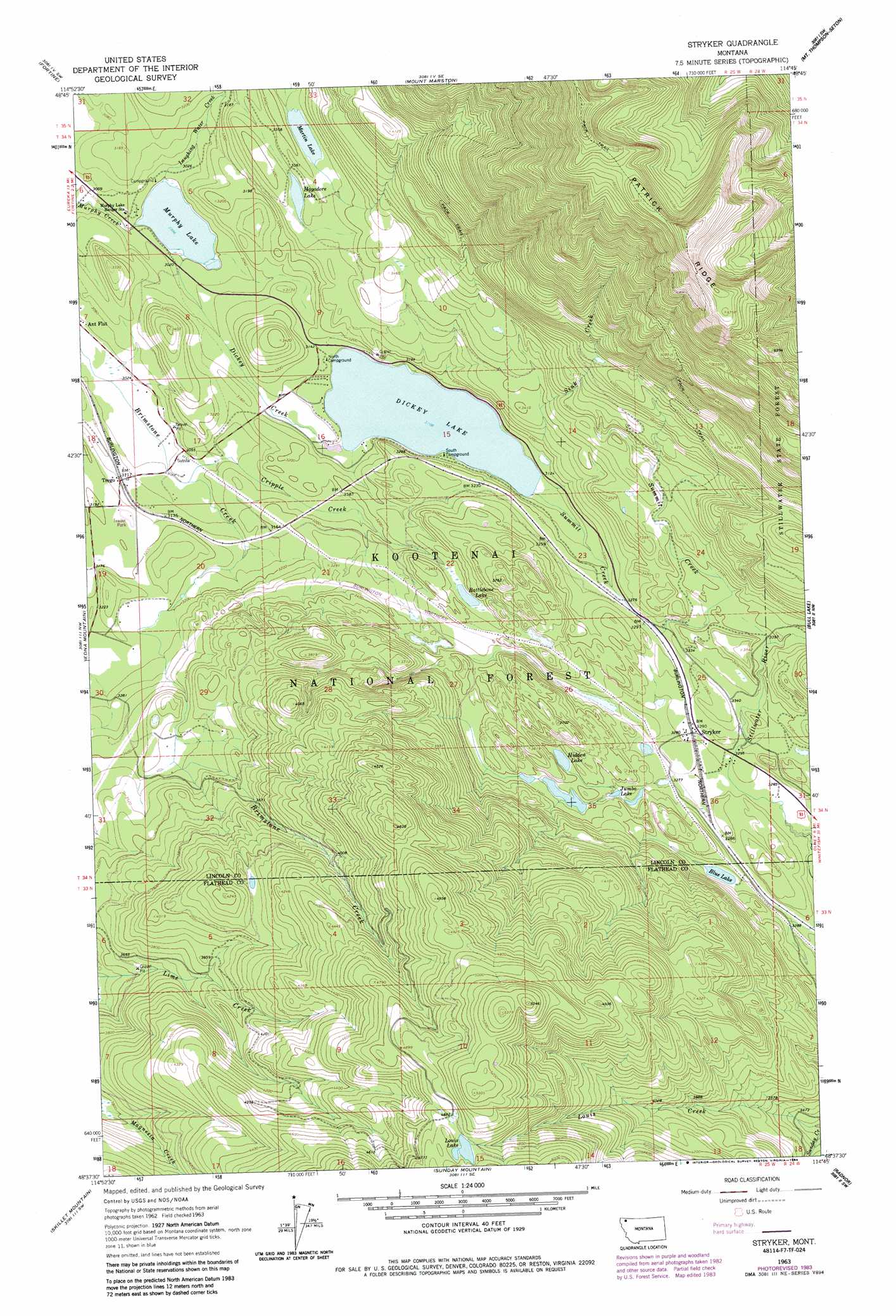
Stryker Topo Map Montana
To zoom in, hover over the map of Stryker
USGS Topo Quad 48114f7 - 1:24,000 scale
| Topo Map Name: | Stryker |
| USGS Topo Quad ID: | 48114f7 |
| Print Size: | ca. 21 1/4" wide x 27" high |
| Southeast Coordinates: | 48.625° N latitude / 114.75° W longitude |
| Map Center Coordinates: | 48.6875° N latitude / 114.8125° W longitude |
| U.S. State: | MT |
| Filename: | o48114f7.jpg |
| Download Map JPG Image: | Stryker topo map 1:24,000 scale |
| Map Type: | Topographic |
| Topo Series: | 7.5´ |
| Map Scale: | 1:24,000 |
| Source of Map Images: | United States Geological Survey (USGS) |
| Alternate Map Versions: |
Stryker MT 1963, updated 1966 Download PDF Buy paper map Stryker MT 1963, updated 1979 Download PDF Buy paper map Stryker MT 1963, updated 1984 Download PDF Buy paper map Stryker MT 1997, updated 2000 Download PDF Buy paper map Stryker MT 2011 Download PDF Buy paper map Stryker MT 2014 Download PDF Buy paper map |
| FStopo: | US Forest Service topo Stryker is available: Download FStopo PDF Download FStopo TIF |
1:24,000 Topo Quads surrounding Stryker
Eureka North |
Ksanka Peak |
Stahl Peak |
Tuchuck Mountain |
Mount Hefty |
Eureka South |
Fortine |
Mount Marston |
Mount Thompson-Seton |
Red Meadow Lake |
Pinkham Mountain |
Edna Mountain |
Stryker |
Bull Lake |
Upper Whitefish Lake |
Davis Mountain |
Skillet Mountain |
Sunday Mountain |
Radnor |
Olney |
Warland Peak |
Bowen Lake |
Dunsire Point |
Johnson Peak |
Tally Lake |
> Back to 48114e1 at 1:100,000 scale
> Back to 48114a1 at 1:250,000 scale
> Back to U.S. Topo Maps home
Stryker topo map: Gazetteer
Stryker: Lakes
Blue Lake elevation 993m 3257′Dickey Lake elevation 949m 3113′
Hagadore Lake elevation 1023m 3356′
Hidden Lake elevation 1029m 3375′
Jumbo Lake elevation 1013m 3323′
Louis Lake elevation 1495m 4904′
Martin Lake elevation 1018m 3339′
Murphy Lake elevation 914m 2998′
Rattlebone Lake elevation 1017m 3336′
Stryker: Populated Places
Stryker elevation 1005m 3297′Trego elevation 950m 3116′
Stryker: Post Offices
Leona Post Office (historical) elevation 996m 3267′Stryker Post Office elevation 1005m 3297′
Trego Post Office elevation 950m 3116′
Stryker: Ridges
Patrick Ridge elevation 2116m 6942′Stryker: Streams
Cripple Creek elevation 929m 3047′Dickey Creek elevation 915m 3001′
Laughing Water Creek elevation 915m 3001′
Sink Creek elevation 989m 3244′
Summit Creek elevation 948m 3110′
Stryker: Wells
34N24W31BC__01 Well elevation 993m 3257′34N25W16ABCB01 Well elevation 952m 3123′
Stryker digital topo map on disk
Buy this Stryker topo map showing relief, roads, GPS coordinates and other geographical features, as a high-resolution digital map file on DVD: