Richards Mountain Topo Map Montana
To zoom in, hover over the map of Richards Mountain
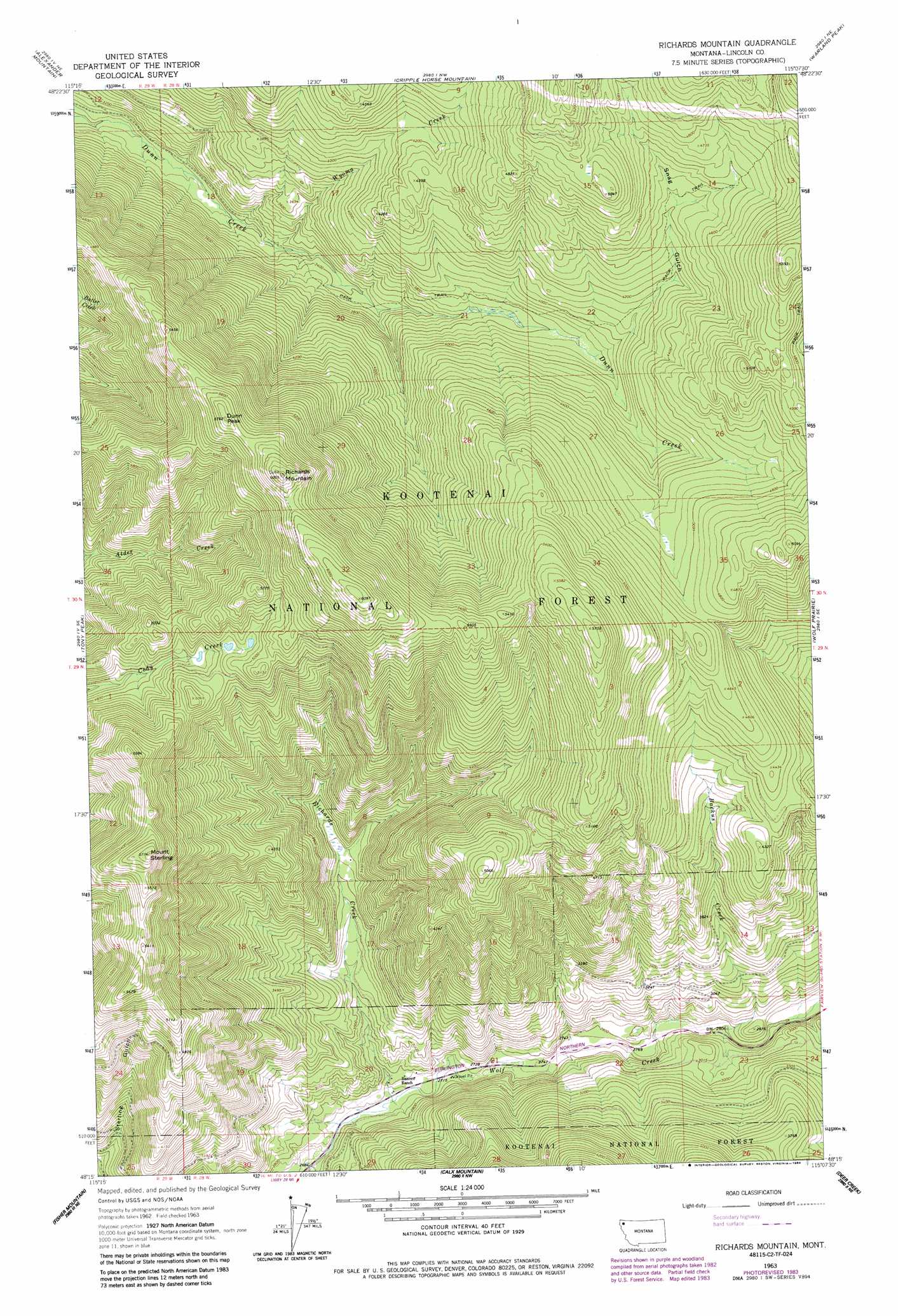
USGS Topo Quad 48115c2 - 1:24,000 scale
| Topo Map Name: | Richards Mountain |
| USGS Topo Quad ID: | 48115c2 |
| Print Size: | ca. 21 1/4" wide x 27" high |
| Southeast Coordinates: | 48.25° N latitude / 115.125° W longitude |
| Map Center Coordinates: | 48.3125° N latitude / 115.1875° W longitude |
| U.S. State: | MT |
| Filename: | o48115c2.jpg |
| Download Map JPG Image: | Richards Mountain topo map 1:24,000 scale |
| Map Type: | Topographic |
| Topo Series: | 7.5´ |
| Map Scale: | 1:24,000 |
| Source of Map Images: | United States Geological Survey (USGS) |
| Alternate Map Versions: |
Richards Mountain MT 1963, updated 1967 Download PDF Buy paper map Richards Mountain MT 1963, updated 1984 Download PDF Buy paper map Richards Mountain MT 1997, updated 2000 Download PDF Buy paper map Richards Mountain MT 2011 Download PDF Buy paper map Richards Mountain MT 2014 Download PDF Buy paper map |
| FStopo: | US Forest Service topo Richards Mountain is available: Download FStopo PDF Download FStopo TIF |
1:24,000 Topo Quads surrounding Richards Mountain
Banfield Mountain |
Ural |
Volcour |
Davis Mountain |
Skillet Mountain |
Vermiculite Mountain |
Alexander Mountain |
Cripple Horse Mountain |
Warland Peak |
Bowen Lake |
Swede Mountain |
Tony Peak |
Richards Mountain |
Wolf Prairie |
Horse Hill |
Horse Mountain |
Fisher Mountain |
Calx Mountain |
Deer Creek |
Lynch Lake |
Barren Peak |
Kenelty Mountain |
Loon Lake |
Thompson Lakes |
Meadow Peak |
> Back to 48115a1 at 1:100,000 scale
> Back to 48114a1 at 1:250,000 scale
> Back to U.S. Topo Maps home
Richards Mountain topo map: Gazetteer
Richards Mountain: Streams
Backus Creek elevation 850m 2788′Richards Creek elevation 824m 2703′
Wyoma Creek elevation 995m 3264′
Richards Mountain: Summits
Dunn Peak elevation 1753m 5751′Mount Sterling elevation 1754m 5754′
Richards Mountain elevation 1830m 6003′
Richards Mountain: Valleys
Snag Gulch elevation 1178m 3864′Richards Mountain digital topo map on disk
Buy this Richards Mountain topo map showing relief, roads, GPS coordinates and other geographical features, as a high-resolution digital map file on DVD: