Newton Mountain Topo Map Montana
To zoom in, hover over the map of Newton Mountain
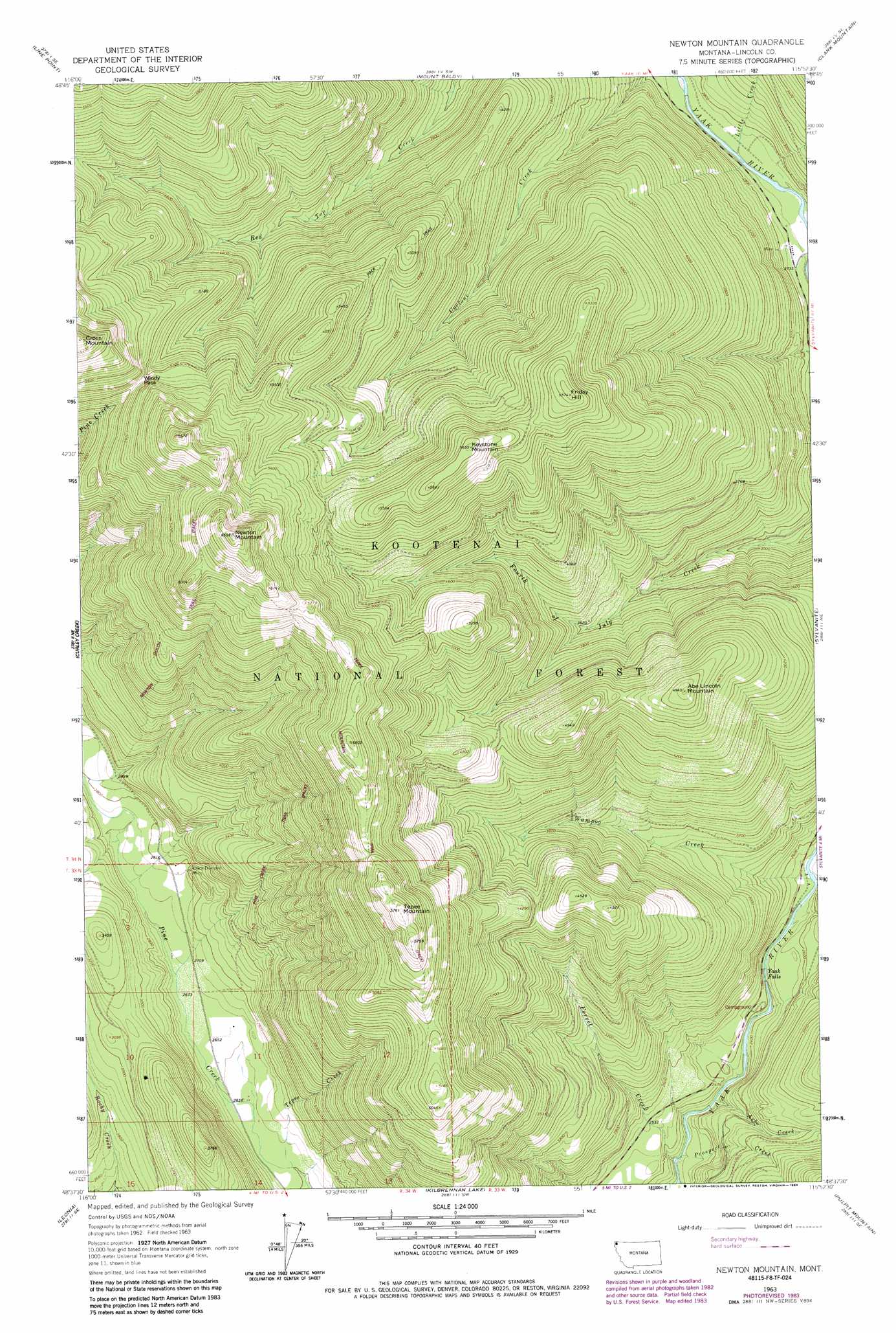
USGS Topo Quad 48115f8 - 1:24,000 scale
| Topo Map Name: | Newton Mountain |
| USGS Topo Quad ID: | 48115f8 |
| Print Size: | ca. 21 1/4" wide x 27" high |
| Southeast Coordinates: | 48.625° N latitude / 115.875° W longitude |
| Map Center Coordinates: | 48.6875° N latitude / 115.9375° W longitude |
| U.S. State: | MT |
| Filename: | o48115f8.jpg |
| Download Map JPG Image: | Newton Mountain topo map 1:24,000 scale |
| Map Type: | Topographic |
| Topo Series: | 7.5´ |
| Map Scale: | 1:24,000 |
| Source of Map Images: | United States Geological Survey (USGS) |
| Alternate Map Versions: |
Newton Mountain MT 1963, updated 1966 Download PDF Buy paper map Newton Mountain MT 1963, updated 1975 Download PDF Buy paper map Newton Mountain MT 1997, updated 2000 Download PDF Buy paper map Newton Mountain MT 2011 Download PDF Buy paper map Newton Mountain MT 2014 Download PDF Buy paper map |
| FStopo: | US Forest Service topo Newton Mountain is available: Download FStopo PDF Download FStopo TIF |
1:24,000 Topo Quads surrounding Newton Mountain
Eastport |
Canuck Peak |
Northwest Peak |
Garver Mountain |
Bonnet Top |
Meadow Creek |
Line Point |
Mount Baldy |
Clark Mountain |
Yaak |
Moyie Springs |
Curley Creek |
Newton Mountain |
Sylvanite |
Flatiron Mountain |
Clifty Mountain |
Leonia |
Kilbrennan Lake |
Pulpit Mountain |
Turner Mountain |
Mount Pend Oreille |
Smith Mountain |
Troy |
Kootenai Falls |
Scenery Mountain |
> Back to 48115e1 at 1:100,000 scale
> Back to 48114a1 at 1:250,000 scale
> Back to U.S. Topo Maps home
Newton Mountain topo map: Gazetteer
Newton Mountain: Falls
Yaak Falls elevation 743m 2437′Newton Mountain: Gaps
Windy Pass elevation 1602m 5255′Newton Mountain: Mines
Black Diamond Mine elevation 867m 2844′Keystone Mine elevation 847m 2778′
Morning Glory Mine elevation 861m 2824′
Morning Glory Mine elevation 894m 2933′
Newton Mountain: Streams
Arbo Creek elevation 703m 2306′Cyclone Creek elevation 839m 2752′
Ferrel Creek elevation 681m 2234′
Little Creek elevation 831m 2726′
Prospect Creek elevation 697m 2286′
Tepee Creek elevation 797m 2614′
Wampoo Creek elevation 762m 2500′
Newton Mountain: Summits
Abe Lincoln Mountain elevation 1491m 4891′Cross Mountain elevation 1943m 6374′
Friday Hill elevation 1697m 5567′
Keystone Mountain elevation 1723m 5652′
Newton Mountain elevation 1990m 6528′
Tepee Mountain elevation 1751m 5744′
Newton Mountain: Trails
Newton Gulch Trail elevation 1388m 4553′Pine Creek Trail elevation 1339m 4393′
Tepee Mountain Trail elevation 1680m 5511′
Newton Mountain digital topo map on disk
Buy this Newton Mountain topo map showing relief, roads, GPS coordinates and other geographical features, as a high-resolution digital map file on DVD: