Yaak Topo Map Montana
To zoom in, hover over the map of Yaak
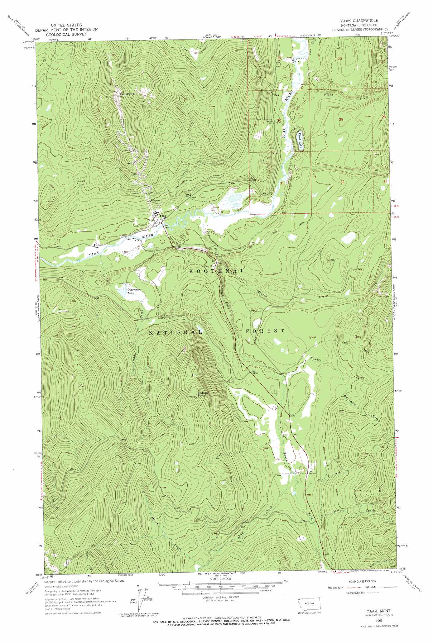
USGS Topo Quad 48115g6 - 1:24,000 scale
| Topo Map Name: | Yaak |
| USGS Topo Quad ID: | 48115g6 |
| Print Size: | ca. 21 1/4" wide x 27" high |
| Southeast Coordinates: | 48.75° N latitude / 115.625° W longitude |
| Map Center Coordinates: | 48.8125° N latitude / 115.6875° W longitude |
| U.S. State: | MT |
| Filename: | o48115g6.jpg |
| Download Map JPG Image: | Yaak topo map 1:24,000 scale |
| Map Type: | Topographic |
| Topo Series: | 7.5´ |
| Map Scale: | 1:24,000 |
| Source of Map Images: | United States Geological Survey (USGS) |
| Alternate Map Versions: |
Yaak MT 1963, updated 1966 Download PDF Buy paper map Yaak MT 1997, updated 2000 Download PDF Buy paper map Yaak MT 2011 Download PDF Buy paper map Yaak MT 2014 Download PDF Buy paper map |
| FStopo: | US Forest Service topo Yaak is available: Download FStopo PDF Download FStopo TIF |
1:24,000 Topo Quads surrounding Yaak
Northwest Peak |
Garver Mountain |
Bonnet Top |
Mount Henry |
Robinson Mountain |
Mount Baldy |
Clark Mountain |
Yaak |
Lost Horse Mountain |
Boulder Lakes |
Newton Mountain |
Sylvanite |
Flatiron Mountain |
Pink Mountain |
Parsnip Mountain |
Kilbrennan Lake |
Pulpit Mountain |
Turner Mountain |
Gold Hill |
Banfield Mountain |
> Back to 48115e1 at 1:100,000 scale
> Back to 48114a1 at 1:250,000 scale
> Back to U.S. Topo Maps home
Yaak topo map: Gazetteer
Yaak: Dams
Obermayer Lake Dam elevation 946m 3103′Yaak: Lakes
Vinal Lake elevation 896m 2939′Yaak: Mines
Yaak Mine elevation 1007m 3303′Yaak: Populated Places
Yaak elevation 910m 2985′Yaak: Post Offices
Taylor Post Office (historical) elevation 900m 2952′Yaak Post Office (historical) elevation 910m 2985′
Yaak: Reservoirs
Obermayer Lake elevation 946m 3103′Yaak: Streams
Beaver Creek elevation 925m 3034′Browning Creek elevation 1061m 3480′
Clay Creek elevation 1038m 3405′
Dutch Creek elevation 1126m 3694′
Fix Creek elevation 1041m 3415′
Fowler Creek elevation 1027m 3369′
Hartman Creek elevation 1073m 3520′
Kelsey Creek elevation 1052m 3451′
Lang Creek elevation 898m 2946′
Lap Creek elevation 1041m 3415′
South Fork Yaak River elevation 897m 2942′
Vinal Creek elevation 897m 2942′
Yaak: Summits
Hensley Hill elevation 1514m 4967′Roderick Butte elevation 1419m 4655′
Yaak digital topo map on disk
Buy this Yaak topo map showing relief, roads, GPS coordinates and other geographical features, as a high-resolution digital map file on DVD: