Cabinet Topo Map Idaho
To zoom in, hover over the map of Cabinet
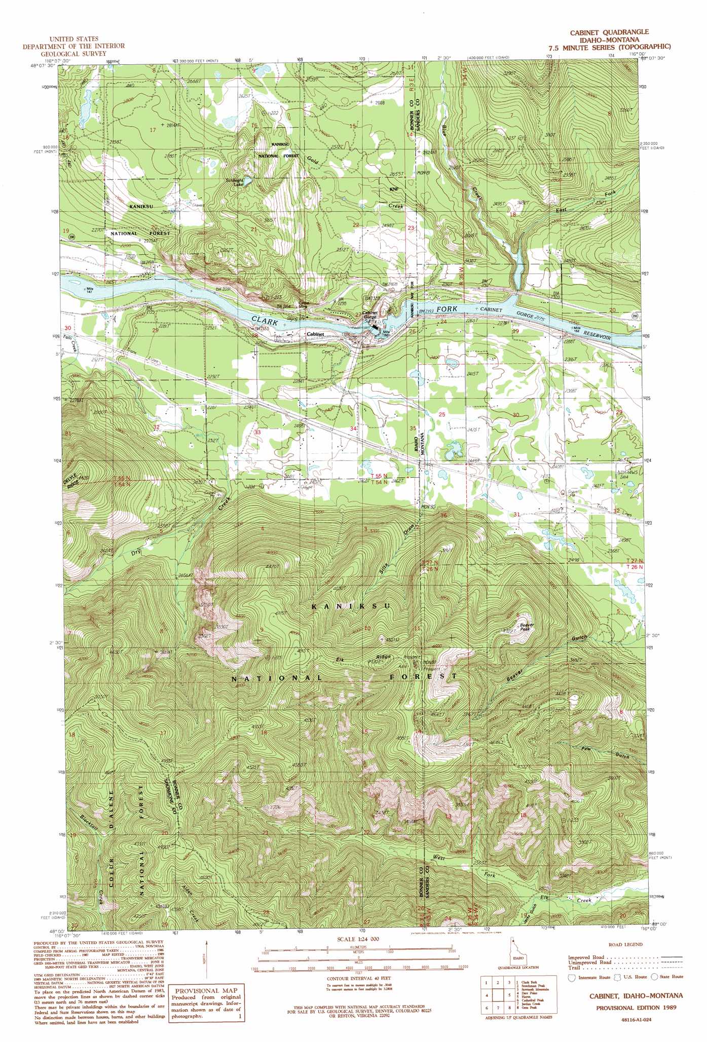
USGS Topo Quad 48116a1 - 1:24,000 scale
| Topo Map Name: | Cabinet |
| USGS Topo Quad ID: | 48116a1 |
| Print Size: | ca. 21 1/4" wide x 27" high |
| Southeast Coordinates: | 48° N latitude / 116° W longitude |
| Map Center Coordinates: | 48.0625° N latitude / 116.0625° W longitude |
| U.S. States: | ID, MT |
| Filename: | o48116a1.jpg |
| Download Map JPG Image: | Cabinet topo map 1:24,000 scale |
| Map Type: | Topographic |
| Topo Series: | 7.5´ |
| Map Scale: | 1:24,000 |
| Source of Map Images: | United States Geological Survey (USGS) |
| Alternate Map Versions: |
Cabinet ID 1989, updated 1989 Download PDF Buy paper map Cabinet ID 2011 Download PDF Buy paper map Cabinet ID 2013 Download PDF Buy paper map |
| FStopo: | US Forest Service topo Cabinet is available: Download FStopo PDF Download FStopo TIF |
1:24,000 Topo Quads surrounding Cabinet
Trout Peak |
Trestle Peak |
Benning Mountain |
Spar Lake |
Crowell Mountain |
Hope |
Clark Fork |
Scotchman Peak |
Sawtooth Mountain |
Ibex Peak |
Packsaddle Mountain |
Derr Point |
Cabinet |
Heron |
Smeads Bench |
Faset Peak |
Cathedral Peak |
Jordan Creek |
Gem Peak |
Noxon |
Lamb Peak |
Spyglass Peak |
Pond Peak |
Taylor Peak |
Bloom Peak |
> Back to 48116a1 at 1:100,000 scale
> Back to 48116a1 at 1:250,000 scale
> Back to U.S. Topo Maps home
Cabinet topo map: Gazetteer
Cabinet: Dams
Cabinet Gorge Dam elevation 635m 2083′Little Blue Dam elevation 722m 2368′
Cabinet: Lakes
Schlicht Lake elevation 922m 3024′Cabinet: Mines
Carpie Mine elevation 671m 2201′Cabinet: Populated Places
Cabinet elevation 669m 2194′Cedar (historical) elevation 677m 2221′
Cabinet: Reservoirs
Cabinet Gorge Reservoir elevation 635m 2083′Cabinet Gorge Reservoir elevation 664m 2178′
Cabinet: Ridges
Elk Ridge elevation 1416m 4645′Cabinet: Streams
Blue Creek elevation 664m 2178′Dry Creek elevation 640m 2099′
East Fork Blue Creek elevation 668m 2191′
Gold Creek elevation 664m 2178′
Gold Creek elevation 664m 2178′
Cabinet: Summits
Beaver Peak elevation 1320m 4330′Cabinet: Valleys
Cabinet Gorge elevation 717m 2352′Jacks Gulch elevation 762m 2500′
Silta Draw elevation 766m 2513′
Cabinet: Wells
27N34W30ADAD01 Well elevation 723m 2372′27N35W24DADA01 Well elevation 710m 2329′
Cabinet digital topo map on disk
Buy this Cabinet topo map showing relief, roads, GPS coordinates and other geographical features, as a high-resolution digital map file on DVD: