Scotchman Peak Topo Map Idaho
To zoom in, hover over the map of Scotchman Peak
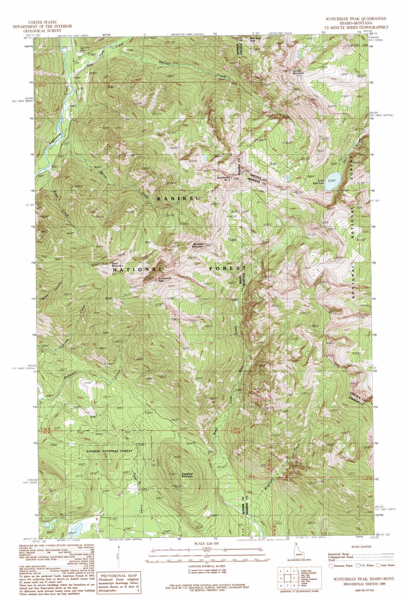
USGS Topo Quad 48116b1 - 1:24,000 scale
| Topo Map Name: | Scotchman Peak |
| USGS Topo Quad ID: | 48116b1 |
| Print Size: | ca. 21 1/4" wide x 27" high |
| Southeast Coordinates: | 48.125° N latitude / 116° W longitude |
| Map Center Coordinates: | 48.1875° N latitude / 116.0625° W longitude |
| U.S. States: | ID, MT |
| Filename: | o48116b1.jpg |
| Download Map JPG Image: | Scotchman Peak topo map 1:24,000 scale |
| Map Type: | Topographic |
| Topo Series: | 7.5´ |
| Map Scale: | 1:24,000 |
| Source of Map Images: | United States Geological Survey (USGS) |
| Alternate Map Versions: |
Scotchman Peak ID 1989, updated 1989 Download PDF Buy paper map Scotchman Peak ID 1996, updated 1999 Download PDF Buy paper map Scotchman Peak ID 2011 Download PDF Buy paper map Scotchman Peak ID 2013 Download PDF Buy paper map |
| FStopo: | US Forest Service topo Scotchman Peak is available: Download FStopo PDF Download FStopo TIF |
1:24,000 Topo Quads surrounding Scotchman Peak
Wylie Knob |
Mount Pend Oreille |
Smith Mountain |
Troy |
Kootenai Falls |
Trout Peak |
Trestle Peak |
Benning Mountain |
Spar Lake |
Crowell Mountain |
Hope |
Clark Fork |
Scotchman Peak |
Sawtooth Mountain |
Ibex Peak |
Packsaddle Mountain |
Derr Point |
Cabinet |
Heron |
Smeads Bench |
Faset Peak |
Cathedral Peak |
Jordan Creek |
Gem Peak |
Noxon |
> Back to 48116a1 at 1:100,000 scale
> Back to 48116a1 at 1:250,000 scale
> Back to U.S. Topo Maps home
Scotchman Peak topo map: Gazetteer
Scotchman Peak: Lakes
Little Sparr Lake elevation 1598m 5242′Scotchman Peak: Streams
East Fork Creek elevation 816m 2677′East Fork Creek elevation 814m 2670′
Morris Creek elevation 784m 2572′
Regal Creek elevation 772m 2532′
Savage Creek elevation 863m 2831′
Savage Creek elevation 861m 2824′
West Fork Blue Creek elevation 782m 2565′
West Fork Blue Creek elevation 781m 2562′
Wiggletail Creek elevation 781m 2562′
Scotchman Peak: Summits
Blacktop Mountain elevation 1953m 6407′East Fork Peak elevation 1742m 5715′
Goat Mountain elevation 1919m 6295′
Savage Mountain elevation 2038m 6686′
Scotchman Number Two elevation 2084m 6837′
Scotchman Peak elevation 2117m 6945′
Sugarloaf Mountain elevation 1279m 4196′
Scotchman Peak digital topo map on disk
Buy this Scotchman Peak topo map showing relief, roads, GPS coordinates and other geographical features, as a high-resolution digital map file on DVD: