Clark Fork Topo Map Idaho
To zoom in, hover over the map of Clark Fork
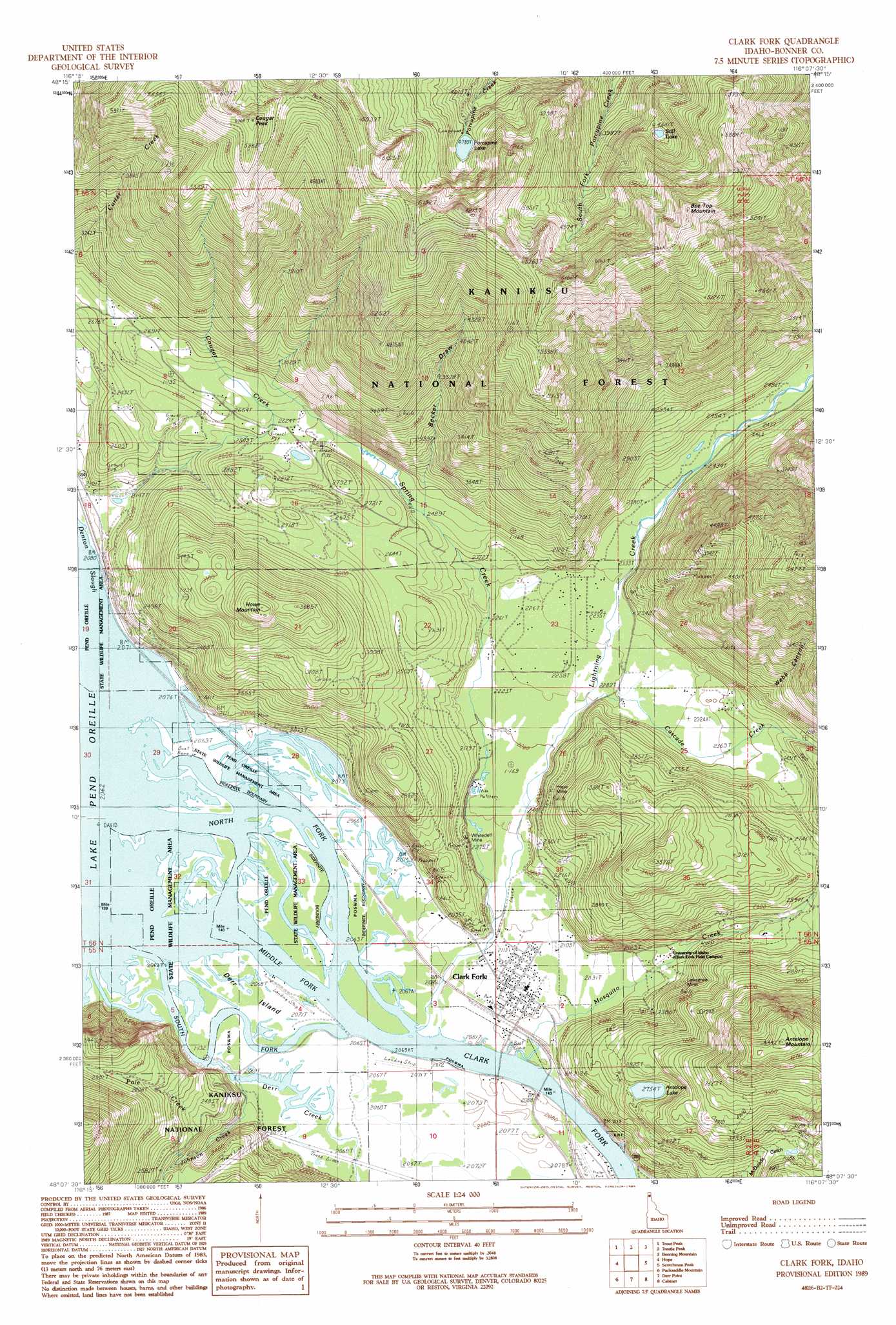
USGS Topo Quad 48116b2 - 1:24,000 scale
| Topo Map Name: | Clark Fork |
| USGS Topo Quad ID: | 48116b2 |
| Print Size: | ca. 21 1/4" wide x 27" high |
| Southeast Coordinates: | 48.125° N latitude / 116.125° W longitude |
| Map Center Coordinates: | 48.1875° N latitude / 116.1875° W longitude |
| U.S. State: | ID |
| Filename: | o48116b2.jpg |
| Download Map JPG Image: | Clark Fork topo map 1:24,000 scale |
| Map Type: | Topographic |
| Topo Series: | 7.5´ |
| Map Scale: | 1:24,000 |
| Source of Map Images: | United States Geological Survey (USGS) |
| Alternate Map Versions: |
Clark Fork ID 1989, updated 1989 Download PDF Buy paper map Clark Fork ID 1996, updated 1999 Download PDF Buy paper map Clark Fork ID 2011 Download PDF Buy paper map Clark Fork ID 2013 Download PDF Buy paper map |
| FStopo: | US Forest Service topo Clark Fork is available: Download FStopo PDF Download FStopo TIF |
1:24,000 Topo Quads surrounding Clark Fork
Elmira |
Wylie Knob |
Mount Pend Oreille |
Smith Mountain |
Troy |
Oden Bay |
Trout Peak |
Trestle Peak |
Benning Mountain |
Spar Lake |
Talache |
Hope |
Clark Fork |
Scotchman Peak |
Sawtooth Mountain |
Minerva Peak |
Packsaddle Mountain |
Derr Point |
Cabinet |
Heron |
Lakeview |
Faset Peak |
Cathedral Peak |
Jordan Creek |
Gem Peak |
> Back to 48116a1 at 1:100,000 scale
> Back to 48116a1 at 1:250,000 scale
> Back to U.S. Topo Maps home
Clark Fork topo map: Gazetteer
Clark Fork: Airports
CX Ranch Airport elevation 632m 2073′Clark Fork: Islands
Derr Island elevation 630m 2066′Clark Fork: Lakes
Antelope Lake elevation 841m 2759′Porcupine Lake elevation 1458m 4783′
Still Lake elevation 1393m 4570′
Clark Fork: Mines
Hope Mine elevation 707m 2319′Lawrence Mine elevation 670m 2198′
Whitedelf Mine elevation 689m 2260′
Clark Fork: Parks
Panhandle Wildlife Mangement Area elevation 630m 2066′Clark Fork: Populated Places
Clark Fork elevation 637m 2089′Denton elevation 643m 2109′
Clark Fork: Streams
Cascade Creek elevation 688m 2257′Cougar Creek elevation 672m 2204′
Derr Creek elevation 631m 2070′
Johnson Creek elevation 632m 2073′
Lightning Creek elevation 630m 2066′
Middle Fork Clark Fork elevation 630m 2066′
Mosquito Creek elevation 630m 2066′
Pole Creek elevation 663m 2175′
South Fork Clark Fork elevation 630m 2066′
Spring Creek elevation 659m 2162′
Clark Fork: Summits
Antelope Mountain elevation 1343m 4406′Bee Top Mountain elevation 1852m 6076′
Cougar Peak elevation 1825m 5987′
Howe Mountain elevation 1162m 3812′
Clark Fork: Trails
Alpine Trail elevation 1682m 5518′Clark Fork: Valleys
Becker Draw elevation 848m 2782′Webb Canyon elevation 827m 2713′
Clark Fork digital topo map on disk
Buy this Clark Fork topo map showing relief, roads, GPS coordinates and other geographical features, as a high-resolution digital map file on DVD: