Hope Topo Map Idaho
To zoom in, hover over the map of Hope
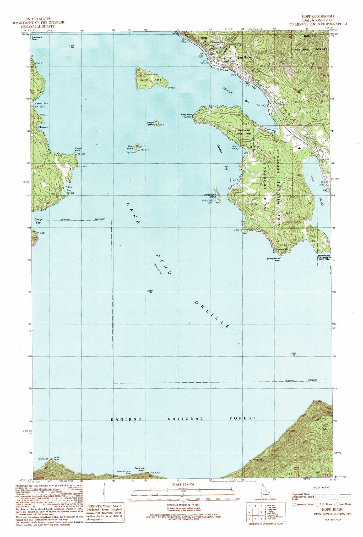
USGS Topo Quad 48116b3 - 1:24,000 scale
| Topo Map Name: | Hope |
| USGS Topo Quad ID: | 48116b3 |
| Print Size: | ca. 21 1/4" wide x 27" high |
| Southeast Coordinates: | 48.125° N latitude / 116.25° W longitude |
| Map Center Coordinates: | 48.1875° N latitude / 116.3125° W longitude |
| U.S. State: | ID |
| Filename: | o48116b3.jpg |
| Download Map JPG Image: | Hope topo map 1:24,000 scale |
| Map Type: | Topographic |
| Topo Series: | 7.5´ |
| Map Scale: | 1:24,000 |
| Source of Map Images: | United States Geological Survey (USGS) |
| Alternate Map Versions: |
Hope ID 1989, updated 1989 Download PDF Buy paper map Hope ID 1996, updated 1999 Download PDF Buy paper map Hope ID 2011 Download PDF Buy paper map Hope ID 2013 Download PDF Buy paper map |
| FStopo: | US Forest Service topo Hope is available: Download FStopo PDF Download FStopo TIF |
1:24,000 Topo Quads surrounding Hope
Colburn |
Elmira |
Wylie Knob |
Mount Pend Oreille |
Smith Mountain |
Sandpoint |
Oden Bay |
Trout Peak |
Trestle Peak |
Benning Mountain |
Sagle |
Talache |
Hope |
Clark Fork |
Scotchman Peak |
Cocolalla |
Minerva Peak |
Packsaddle Mountain |
Derr Point |
Cabinet |
Bayview |
Lakeview |
Faset Peak |
Cathedral Peak |
Jordan Creek |
> Back to 48116a1 at 1:100,000 scale
> Back to 48116a1 at 1:250,000 scale
> Back to U.S. Topo Maps home
Hope topo map: Gazetteer
Hope: Airports
Lake Pend Oreille Seaplane Base elevation 630m 2066′Hope: Bays
Camp Bay elevation 630m 2066′Elliot Bay elevation 630m 2066′
Ellisport Bay elevation 630m 2066′
Martin Bay elevation 630m 2066′
Owens Bay elevation 630m 2066′
Sunrise Bay elevation 630m 2066′
Hope: Capes
Deadman Point elevation 630m 2066′Hope Point elevation 655m 2148′
Indian Point elevation 667m 2188′
Picard Point elevation 634m 2080′
Sheepherder Point elevation 636m 2086′
Hope: Guts
Denton Slough elevation 630m 2066′Hope: Islands
Cottage Island elevation 635m 2083′Memaloose Island elevation 635m 2083′
Pearl Island elevation 635m 2083′
Warren Island elevation 650m 2132′
Hope: Lakes
Lake Pend Oreille elevation 630m 2066′Hope: Mines
Sulphide Mine elevation 666m 2185′Hope: Parks
David Thompson State Wildlife Preserve elevation 767m 2516′Samowen Park elevation 639m 2096′
Hope: Populated Places
East Hope elevation 663m 2175′Glengary elevation 648m 2125′
Hope elevation 668m 2191′
Hope: Streams
Carter Creek elevation 720m 2362′Clark Fork elevation 630m 2066′
North Fork Clark Fork elevation 630m 2066′
Riser Creek elevation 631m 2070′
Strong Creek elevation 650m 2132′
Hope: Summits
Jakes Mountain elevation 1417m 4648′Hope digital topo map on disk
Buy this Hope topo map showing relief, roads, GPS coordinates and other geographical features, as a high-resolution digital map file on DVD: