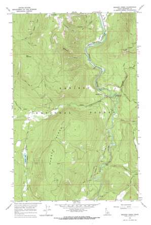
Meadow Creek Topo Map Idaho
To zoom in, hover over the map of Meadow Creek
USGS Topo Quad 48116g2 - 1:24,000 scale
| Topo Map Name: | Meadow Creek |
| USGS Topo Quad ID: | 48116g2 |
| Print Size: | ca. 21 1/4" wide x 27" high |
| Southeast Coordinates: | 48.75° N latitude / 116.125° W longitude |
| Map Center Coordinates: | 48.8125° N latitude / 116.1875° W longitude |
| U.S. State: | ID |
| Filename: | o48116g2.jpg |
| Download Map JPG Image: | Meadow Creek topo map 1:24,000 scale |
| Map Type: | Topographic |
| Topo Series: | 7.5´ |
| Map Scale: | 1:24,000 |
| Source of Map Images: | United States Geological Survey (USGS) |
| Alternate Map Versions: |
Meadow Creek ID 1965, updated 1967 Download PDF Buy paper map Meadow Creek ID 1965, updated 1967 Download PDF Buy paper map Meadow Creek ID 1996, updated 1999 Download PDF Buy paper map Meadow Creek ID 2011 Download PDF Buy paper map Meadow Creek ID 2013 Download PDF Buy paper map |
| FStopo: | US Forest Service topo Meadow Creek is available: Download FStopo PDF Download FStopo TIF |
1:24,000 Topo Quads surrounding Meadow Creek
> Back to 48116e1 at 1:100,000 scale
> Back to 48116a1 at 1:250,000 scale
> Back to U.S. Topo Maps home
Meadow Creek topo map: Gazetteer
Meadow Creek: Bridges
Twin Bridges elevation 746m 2447′Meadow Creek: Lakes
Dawson Lake elevation 894m 2933′Meadow Creek: Populated Places
Eileen elevation 722m 2368′Meadow Creek elevation 733m 2404′
Meadow Creek: Ridges
Dawson Ridge elevation 1356m 4448′Meadow Creek: Streams
Deer Creek elevation 680m 2230′McDougal Creek elevation 740m 2427′
Meadow Creek elevation 709m 2326′
Placer Creek elevation 1027m 3369′
Rutledge Creek elevation 751m 2463′
Skin Creek elevation 700m 2296′
Skin Creek elevation 700m 2296′
Snyder Creek elevation 751m 2463′
Wall Creek elevation 844m 2769′
Meadow Creek: Summits
Wall Mountain elevation 1566m 5137′Meadow Creek: Trails
Rutledge Creek Trail elevation 1471m 4826′Meadow Creek digital topo map on disk
Buy this Meadow Creek topo map showing relief, roads, GPS coordinates and other geographical features, as a high-resolution digital map file on DVD:


