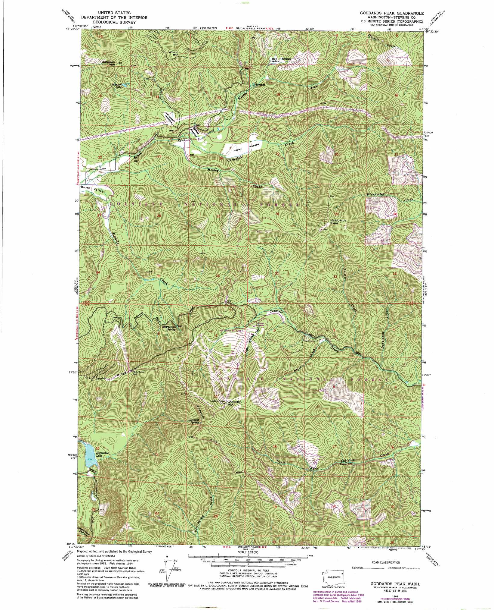
Goddards Peak Topo Map Washington
To zoom in, hover over the map of Goddards Peak
USGS Topo Quad 48117c5 - 1:24,000 scale
| Topo Map Name: | Goddards Peak |
| USGS Topo Quad ID: | 48117c5 |
| Print Size: | ca. 21 1/4" wide x 27" high |
| Southeast Coordinates: | 48.25° N latitude / 117.5° W longitude |
| Map Center Coordinates: | 48.3125° N latitude / 117.5625° W longitude |
| U.S. State: | WA |
| Filename: | o48117c5.jpg |
| Download Map JPG Image: | Goddards Peak topo map 1:24,000 scale |
| Map Type: | Topographic |
| Topo Series: | 7.5´ |
| Map Scale: | 1:24,000 |
| Source of Map Images: | United States Geological Survey (USGS) |
| Alternate Map Versions: |
Goddards Peak WA 1964, updated 1966 Download PDF Buy paper map Goddards Peak WA 1964, updated 1975 Download PDF Buy paper map Goddards Peak WA 1964, updated 1981 Download PDF Buy paper map Goddards Peak WA 1964, updated 1986 Download PDF Buy paper map Goddards Peak WA 1992, updated 1996 Download PDF Buy paper map Goddards Peak WA 2011 Download PDF Buy paper map Goddards Peak WA 2014 Download PDF Buy paper map |
| FStopo: | US Forest Service topo Goddards Peak is available: Download FStopo PDF Download FStopo TIF |
1:24,000 Topo Quads surrounding Goddards Peak
White Mud Lake |
Park Rapids |
Lake Gillette |
Timber Mountain |
Ruby |
Addy Mountain |
Cliff Ridge |
Calispell Peak |
Tacoma Peak |
Jared |
Addy |
Chewelah |
Goddards Peak |
Winchester Peak |
Cusick |
Waitts Lake |
Valley |
Nelson Peak |
Boyer Mountain |
Sacheen Lake |
Forest Center |
Springdale |
Deer Lake |
Fan Lake |
Elk |
> Back to 48117a1 at 1:100,000 scale
> Back to 48116a1 at 1:250,000 scale
> Back to U.S. Topo Maps home
Goddards Peak topo map: Gazetteer
Goddards Peak: Flats
Bell Meadow elevation 1106m 3628′Bisbee Meadow elevation 998m 3274′
Dahlstrom Meadow elevation 1031m 3382′
Healey Meadow elevation 1022m 3353′
Goddards Peak: Lakes
Horseshoe Lake elevation 935m 3067′Johnson Lake elevation 1209m 3966′
Goddards Peak: Ridges
Jay Gould Ridge elevation 1279m 4196′Goddards Peak: Springs
Lookout Spring elevation 1558m 5111′McPherson Spring elevation 1171m 3841′
Goddards Peak: Streams
Donaldson Creek elevation 969m 3179′Healey Creek elevation 967m 3172′
Little Calispell Creek elevation 1140m 3740′
Nelson Creek elevation 1047m 3435′
Palmer Creek elevation 1006m 3300′
Wilson Creek elevation 1265m 4150′
Goddards Peak: Summits
Chewelah Mountain elevation 1759m 5770′Goddards Peak elevation 1687m 5534′
Johnson Mountain elevation 1367m 4484′
Wilson Mountain elevation 1374m 4507′
Goddards Peak digital topo map on disk
Buy this Goddards Peak topo map showing relief, roads, GPS coordinates and other geographical features, as a high-resolution digital map file on DVD: