Cliff Ridge Topo Map Washington
To zoom in, hover over the map of Cliff Ridge
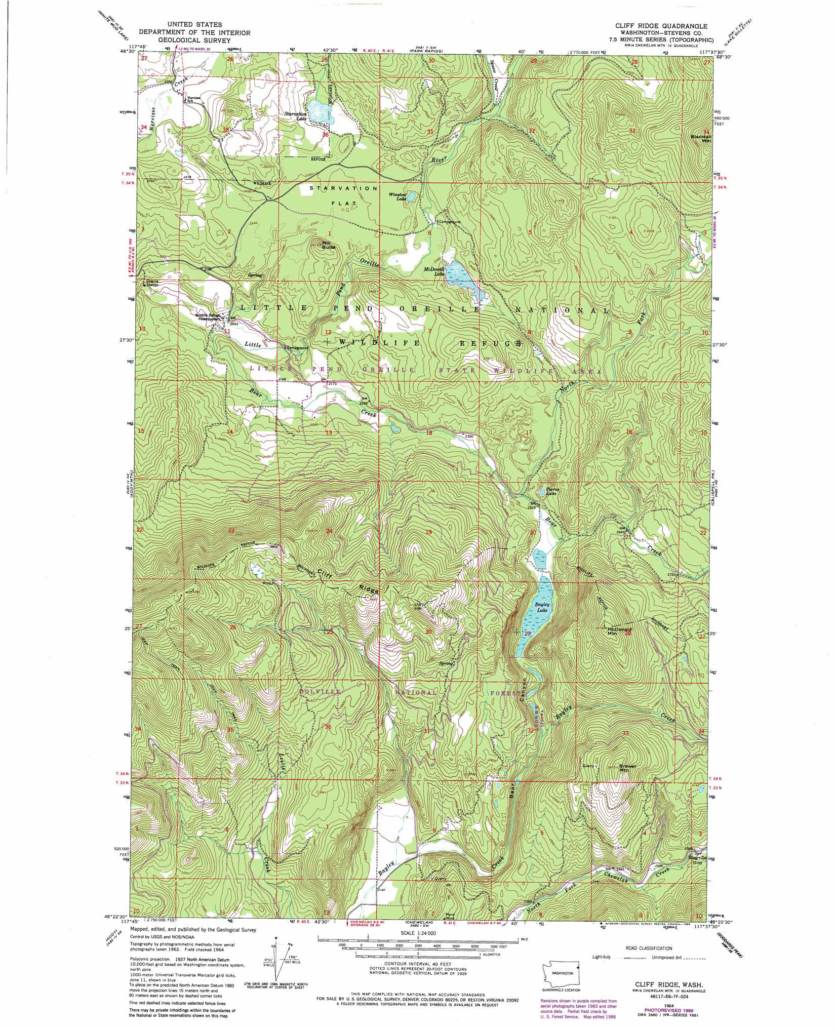
USGS Topo Quad 48117d6 - 1:24,000 scale
| Topo Map Name: | Cliff Ridge |
| USGS Topo Quad ID: | 48117d6 |
| Print Size: | ca. 21 1/4" wide x 27" high |
| Southeast Coordinates: | 48.375° N latitude / 117.625° W longitude |
| Map Center Coordinates: | 48.4375° N latitude / 117.6875° W longitude |
| U.S. State: | WA |
| Filename: | o48117d6.jpg |
| Download Map JPG Image: | Cliff Ridge topo map 1:24,000 scale |
| Map Type: | Topographic |
| Topo Series: | 7.5´ |
| Map Scale: | 1:24,000 |
| Source of Map Images: | United States Geological Survey (USGS) |
| Alternate Map Versions: |
Cliff Ridge WA 1964, updated 1966 Download PDF Buy paper map Cliff Ridge WA 1964, updated 1976 Download PDF Buy paper map Cliff Ridge WA 1964, updated 1981 Download PDF Buy paper map Cliff Ridge WA 1964, updated 1986 Download PDF Buy paper map Cliff Ridge WA 1964, updated 1986 Download PDF Buy paper map Cliff Ridge WA 1992, updated 1996 Download PDF Buy paper map Cliff Ridge WA 2011 Download PDF Buy paper map Cliff Ridge WA 2014 Download PDF Buy paper map |
| FStopo: | US Forest Service topo Cliff Ridge is available: Download FStopo PDF Download FStopo TIF |
1:24,000 Topo Quads surrounding Cliff Ridge
Echo Valley |
Gillette Mountain |
Aladdin |
Aladdin Mountain |
Ione |
Colville |
White Mud Lake |
Park Rapids |
Lake Gillette |
Timber Mountain |
Arden |
Addy Mountain |
Cliff Ridge |
Calispell Peak |
Tacoma Peak |
Dunn Mountain |
Addy |
Chewelah |
Goddards Peak |
Winchester Peak |
Stensgar Mountain |
Waitts Lake |
Valley |
Nelson Peak |
Boyer Mountain |
> Back to 48117a1 at 1:100,000 scale
> Back to 48116a1 at 1:250,000 scale
> Back to U.S. Topo Maps home
Cliff Ridge topo map: Gazetteer
Cliff Ridge: Dams
McDowell Lake Dam elevation 703m 2306′Cliff Ridge: Flats
Starvation Flat elevation 718m 2355′Cliff Ridge: Lakes
Bayley Lake elevation 714m 2342′Pierce Lake elevation 690m 2263′
Starvation Lake elevation 722m 2368′
Winslow Lake elevation 706m 2316′
Cliff Ridge: Mines
Perry Mine elevation 880m 2887′Cliff Ridge: Parks
Little Pend Orielle State Wildlife Area elevation 1100m 3608′Cliff Ridge: Populated Places
Bingville elevation 786m 2578′Cliff Ridge: Reservoirs
McDowell Lake elevation 703m 2306′Cliff Ridge: Ridges
Cliff Ridge elevation 1101m 3612′Cliff Ridge: Streams
Aspen Creek elevation 732m 2401′Bear Creek elevation 610m 2001′
North Fork Bear Creek elevation 700m 2296′
Cliff Ridge: Summits
Brewer Mountain elevation 1114m 3654′McDonald Mountain elevation 1113m 3651′
Mill Butte elevation 797m 2614′
Cliff Ridge: Valleys
Bear Canyon elevation 669m 2194′Cliff Ridge digital topo map on disk
Buy this Cliff Ridge topo map showing relief, roads, GPS coordinates and other geographical features, as a high-resolution digital map file on DVD: