Spirit Topo Map Washington
To zoom in, hover over the map of Spirit
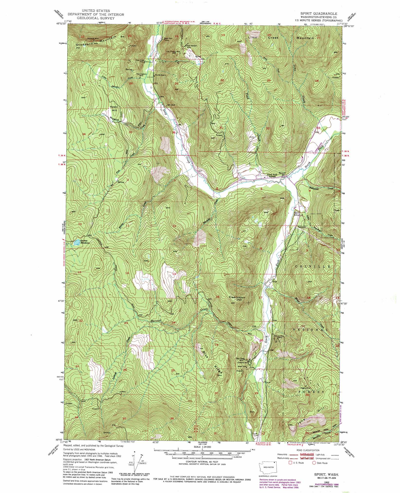
USGS Topo Quad 48117g6 - 1:24,000 scale
| Topo Map Name: | Spirit |
| USGS Topo Quad ID: | 48117g6 |
| Print Size: | ca. 21 1/4" wide x 27" high |
| Southeast Coordinates: | 48.75° N latitude / 117.625° W longitude |
| Map Center Coordinates: | 48.8125° N latitude / 117.6875° W longitude |
| U.S. State: | WA |
| Filename: | o48117g6.jpg |
| Download Map JPG Image: | Spirit topo map 1:24,000 scale |
| Map Type: | Topographic |
| Topo Series: | 7.5´ |
| Map Scale: | 1:24,000 |
| Source of Map Images: | United States Geological Survey (USGS) |
| Alternate Map Versions: |
Spirit WA 1952, updated 1953 Download PDF Buy paper map Spirit WA 1952, updated 1970 Download PDF Buy paper map Spirit WA 1952, updated 1978 Download PDF Buy paper map Spirit WA 1952, updated 1982 Download PDF Buy paper map Spirit WA 1952, updated 1986 Download PDF Buy paper map Spirit WA 1992, updated 1997 Download PDF Buy paper map Spirit WA 2011 Download PDF Buy paper map Spirit WA 2014 Download PDF Buy paper map |
| FStopo: | US Forest Service topo Spirit is available: Download FStopo PDF Download FStopo TIF |
1:24,000 Topo Quads surrounding Spirit
Belshazzar Mountain |
Northport |
Boundary |
Leadpoint |
Abercrombie Mountain |
China Bend |
Onion Creek |
Spirit |
Deep Lake |
Metaline |
Echo Valley |
Gillette Mountain |
Aladdin |
Aladdin Mountain |
Ione |
Colville |
White Mud Lake |
Park Rapids |
Lake Gillette |
Timber Mountain |
> Back to 48117e1 at 1:100,000 scale
> Back to 48116a1 at 1:250,000 scale
> Back to U.S. Topo Maps home
Spirit topo map: Gazetteer
Spirit: Lakes
Quinns Meadows elevation 1035m 3395′Spirit: Mines
Black Rock Mine elevation 625m 2050′Blue Ridge Mine elevation 683m 2240′
Copper King Mine elevation 723m 2372′
Deep Creek Mine elevation 572m 1876′
Great Western Mine elevation 975m 3198′
Last Chance Mine 3057 elevation 893m 2929′
Magma Mine elevation 928m 3044′
Marble Quarry elevation 602m 1975′
New England Mine elevation 574m 1883′
Stonewall Mine elevation 1019m 3343′
Spirit: Populated Places
Goldfield Mill elevation 659m 2162′Spirit elevation 594m 1948′
Spirit: Ridges
Blue Ridge elevation 993m 3257′Spirit: Streams
Harrier Creek elevation 622m 2040′Lime Creek elevation 600m 1968′
Little Johnson Creek elevation 573m 1879′
Little Smackout Creek elevation 591m 1938′
Lookout Creek elevation 850m 2788′
Martella Creek elevation 584m 1916′
Miller Creek elevation 612m 2007′
North Fork Deep Creek elevation 587m 1925′
Pick Creek elevation 705m 2312′
Raisio Creek elevation 588m 1929′
Smackout Creek elevation 594m 1948′
South Fork Deep Creek elevation 587m 1925′
Todd Creek elevation 586m 1922′
Waymire Creek elevation 574m 1883′
West Fork Lime Creek elevation 827m 2713′
Spirit: Summits
Frederickson Hill elevation 956m 3136′Ione Hill elevation 1027m 3369′
Koski Hill elevation 892m 2926′
Stoddard Mountain elevation 1085m 3559′
Spirit digital topo map on disk
Buy this Spirit topo map showing relief, roads, GPS coordinates and other geographical features, as a high-resolution digital map file on DVD: