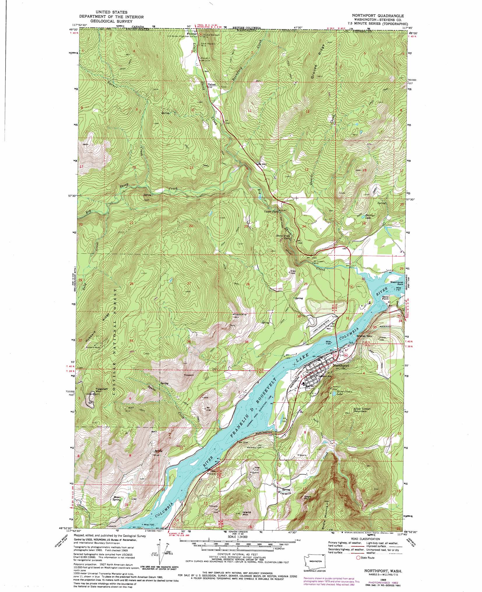
Northport Topo Map Washington
To zoom in, hover over the map of Northport
USGS Topo Quad 48117h7 - 1:24,000 scale
| Topo Map Name: | Northport |
| USGS Topo Quad ID: | 48117h7 |
| Print Size: | ca. 21 1/4" wide x 27" high |
| Southeast Coordinates: | 48.875° N latitude / 117.75° W longitude |
| Map Center Coordinates: | 48.9375° N latitude / 117.8125° W longitude |
| U.S. State: | WA |
| Filename: | o48117h7.jpg |
| Download Map JPG Image: | Northport topo map 1:24,000 scale |
| Map Type: | Topographic |
| Topo Series: | 7.5´ |
| Map Scale: | 1:24,000 |
| Source of Map Images: | United States Geological Survey (USGS) |
| Alternate Map Versions: |
Northport WA 1969, updated 1972 Download PDF Buy paper map Northport WA 1969, updated 1982 Download PDF Buy paper map Northport WA 1992, updated 1997 Download PDF Buy paper map Northport WA 1992, updated 1997 Download PDF Buy paper map Northport WA 2011 Download PDF Buy paper map Northport WA 2014 Download PDF Buy paper map |
| FStopo: | US Forest Service topo Northport is available: Download FStopo PDF Download FStopo TIF |
1:24,000 Topo Quads surrounding Northport
Churchill Mountain |
Belshazzar Mountain |
Northport |
Boundary |
Leadpoint |
Bossburg |
China Bend |
Onion Creek |
Spirit |
Deep Lake |
Marcus |
Echo Valley |
Gillette Mountain |
Aladdin |
Aladdin Mountain |
> Back to 48117e1 at 1:100,000 scale
> Back to 48116a1 at 1:250,000 scale
> Back to U.S. Topo Maps home
Northport topo map: Gazetteer
Northport: Capes
Sand Point elevation 394m 1292′Northport: Falls
Sheep Creek Falls elevation 467m 1532′Upper Falls elevation 545m 1788′
Northport: Islands
Smelter Rock elevation 394m 1292′Steamboat Rock elevation 397m 1302′
Northport: Lakes
Phillips Lake elevation 555m 1820′Silver Crown Lake elevation 693m 2273′
Northport: Mines
Coyote Mine elevation 790m 2591′Double Standard Mine elevation 775m 2542′
Great Republic Mine elevation 691m 2267′
Hubbard Mine elevation 1199m 3933′
Saint Crispen Mine elevation 403m 1322′
Northport: Parks
Sheep Creek Recreation Site elevation 596m 1955′Northport: Populated Places
Frontier elevation 666m 2185′Northport elevation 416m 1364′
Velvet elevation 648m 2125′
Northport: Ridges
Grouse Ridge elevation 1283m 4209′Hubbard Ridge elevation 1239m 4064′
Northport: Springs
Moses Spring elevation 550m 1804′Northport: Streams
Bear Creek elevation 402m 1318′Big Sheep Creek elevation 394m 1292′
Boundary Creek elevation 636m 2086′
Deep Creek elevation 397m 1302′
Fivemile Creek elevation 399m 1309′
Gold Creek elevation 624m 2047′
Little Sheep Creek elevation 560m 1837′
Quartz Creek elevation 398m 1305′
Squaw Creek elevation 394m 1292′
Turner Creek elevation 603m 1978′
Northport: Summits
Eagle Peak elevation 716m 2349′Flagstaff Mountain elevation 1299m 4261′
Grouse Mountain elevation 1039m 3408′
Island Mountain elevation 843m 2765′
Silver Crown Mountain elevation 893m 2929′
Northport digital topo map on disk
Buy this Northport topo map showing relief, roads, GPS coordinates and other geographical features, as a high-resolution digital map file on DVD: