Belshazzar Mountain Topo Map Washington
To zoom in, hover over the map of Belshazzar Mountain
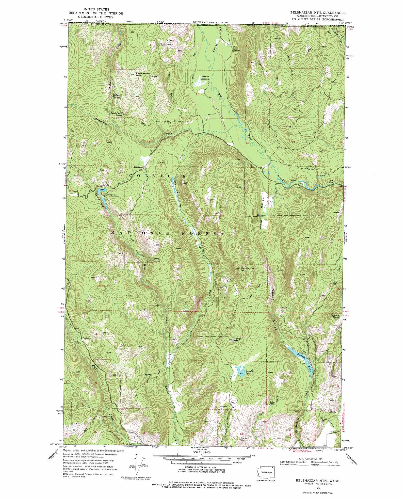
USGS Topo Quad 48117h8 - 1:24,000 scale
| Topo Map Name: | Belshazzar Mountain |
| USGS Topo Quad ID: | 48117h8 |
| Print Size: | ca. 21 1/4" wide x 27" high |
| Southeast Coordinates: | 48.875° N latitude / 117.875° W longitude |
| Map Center Coordinates: | 48.9375° N latitude / 117.9375° W longitude |
| U.S. State: | WA |
| Filename: | o48117h8.jpg |
| Download Map JPG Image: | Belshazzar Mountain topo map 1:24,000 scale |
| Map Type: | Topographic |
| Topo Series: | 7.5´ |
| Map Scale: | 1:24,000 |
| Source of Map Images: | United States Geological Survey (USGS) |
| Alternate Map Versions: |
Belshazzar Mtn WA 1969, updated 1971 Download PDF Buy paper map Belshazzar Mtn WA 1969, updated 1978 Download PDF Buy paper map Belshazzar Mtn WA 1992, updated 1996 Download PDF Buy paper map Belshazzar Mtn WA 1992, updated 1996 Download PDF Buy paper map Belshazzar Mountain WA 2011 Download PDF Buy paper map Belshazzar Mountain WA 2014 Download PDF Buy paper map |
| FStopo: | US Forest Service topo Belshazzar Mountain is available: Download FStopo PDF Download FStopo TIF |
1:24,000 Topo Quads surrounding Belshazzar Mountain
Laurier |
Churchill Mountain |
Belshazzar Mountain |
Northport |
Boundary |
Orient |
Bossburg |
China Bend |
Onion Creek |
Spirit |
Boyds |
Marcus |
Echo Valley |
Gillette Mountain |
Aladdin |
> Back to 48117e1 at 1:100,000 scale
> Back to 48116a1 at 1:250,000 scale
> Back to U.S. Topo Maps home
Belshazzar Mountain topo map: Gazetteer
Belshazzar Mountain: Basins
Sleepy Hollow elevation 679m 2227′Belshazzar Mountain: Flats
Bennett Meadow elevation 658m 2158′Belshazzar Mountain: Lakes
Ansaldo Lake elevation 953m 3126′Elbow Lake elevation 878m 2880′
Pepoon Lake elevation 731m 2398′
Belshazzar Mountain: Mines
Bullion Mine elevation 966m 3169′Chief Joseph Mine elevation 970m 3182′
Belshazzar Mountain: Springs
Lead Pencil Spring elevation 901m 2956′Zodiac Spring elevation 877m 2877′
Belshazzar Mountain: Streams
American Fork Big Sheep Creek elevation 653m 2142′Corral Creek elevation 656m 2152′
East Fork Crown Creek elevation 634m 2080′
West Fork Crown Creek elevation 634m 2080′
Zodiac Creek elevation 814m 2670′
Belshazzar Mountain: Summits
Belshazzar Mountain elevation 1193m 3914′Cougar Mountain elevation 1102m 3615′
Lead Pencil Mountain elevation 1115m 3658′
Belshazzar Mountain: Valleys
Pepoon Canyon elevation 753m 2470′Belshazzar Mountain digital topo map on disk
Buy this Belshazzar Mountain topo map showing relief, roads, GPS coordinates and other geographical features, as a high-resolution digital map file on DVD: